Sunday, 15 August 2021

Stages 55-56: Belmullet to Bangor Erris

                Stage 55

            Co. Mayo: Belmullet to Gaoth Saile

                    Saturday 14 Aug. 2021

                    41km or 25.5miles

‘’Isn't there the light of seven heavens in your heart alone, the way you'll be an angel's lamp to me from this out, and I abroad in the darkness, spearing salmons in the Owen, or the Carrowmore” John Millington Synge from ‘Playboy of the Western World’

It’s so nice to return to this part of Mayo. I think Maureen, Brian and I fell in love with the Mullet Peninsula in July. This time we are staying at Kemar House, just west of Belmullet town. Our host, another Maureen, is looking after us and leaves out some weetabix, milk and fruit for my early start. As I step outside the door at 6.20am I’m just in time to witness the most a beautiful sunrise which gives me a spring in my step as I run towards Belmullet. The town is very quiet at this time of the morning but during the day it can be a busy place. It is without doubt the capital of Erris.

Sunrise over Erris as I start my run

Belmullet Town (Beal an Mhuirthead)

In 1822 William Henry Carter inherited many acres of land in north west Mayo and built this new town on the edge of the Mullet peninsula. The new town impressed, Alexander Nimmo, a famous engineer who built harbours and piers all over Ireland and he wrote as follows:

 "At Belmullet, the advance is quite surprising; the place only commenced four years ago; it now consists of about seventy respectable houses’’ 

In the 1830s, another visitor described Belmullet as "the youngest town in Ireland and like all young things it is comparatively fresh and fair’’.

However, seventy years later Belmullet seemed to have let itself go. The famous written, John Millington Synge, visited Belmullet in 1904, and reported: 

‘’Belmullet in the evening is noisy and squalid, lonely and crowded at the same time and without appeal to the imagination’’

Of course, in those seventy years Ireland suffered its biggest natural disaster with the famine in the 1840’s. At one stage at the height of the Famine, 3,000 people were recorded as being in the local workhouse.

After leaving Belmullet I stick to the Shore Road and run pass the outdoor Tidal Pool. We’ve noticed on previous visits how popular this unique swimming area is with all the young people. Just after the tidal pool I take a left turn onto Cois Fhairraige which brings me up onto Church Road and I leave the Mullet peninsula by this quieter coastal road. I’m heading for Claggan Island across the bay and maybe there is an option for taking a short cut along the sand. However low tide was already at 4.30am so I stick by the country road. In any case it is well signposted to Claggan Island (Oilean Chloigeann). Even at high tide it would be still possible to cross over to the island as there is a tombola (a long bar of sand) from the mainland. 

Sign pointing down to Claggan Island and Srah Beach

View of Claggan Island

 
Claggan Island

Claggan was only declared an island in 1991. In January of that year there was a ‘wind-storm’ from the North Atlantic that cut off the island from the mainland for days. More recently the old Coastguard Station has been renovated by the Howard family. They converted it into self-catering accommodation and glamping pods. I was delighted to meet father and son, both called Laurence Howard, who had a very warm welcome for me. Their family have farmed on the island for four generations. An even younger generation is coming along to keep the tradition going!

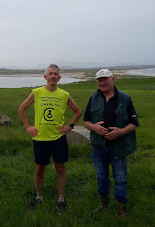
With Laurence Junior and Senior on Claggan Island


With Laurence Senior

I had heard about a sculpture on the island that commemorated the unbaptised who were buried on the island. Both men took me to see it. These burial sites are called cillíns and in a field on Claggan Island there is a mound of earth where those that were ‘declared unworthy’ were buried. A sculpture by the artist, Marian O'Donnell's consists of two curved stone walls facing each other but separated from each other by a narrow passageway. 
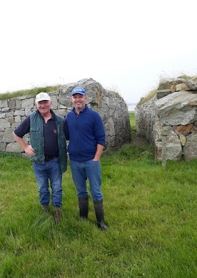
Cillin Sculpture showing passage between two curved walls

I was privileged to be able to walk between the two stone walls which symbolises that you are embracing, protecting, and acknowledging those buried in the cillín. I came across a similar island in Donegal, called Oilean na Marbh (Island of dead) where hundreds of babies were buried. (See stage 28 in the Ulster Coastal Run book). Here in Claggan Island there is a poignant inscription by the poet Derek Mahon

‘’They are begging us to see in their wordless way, to do something, to speak on their behalf. Or at least not to close the door again’’

I could have chatted to the two Laurence’s all day. They were so modest but so proud to show me around. I appreciated a good pint of water too, to quench my thirst, as I knew I still had a long way to go today. Yes Claggan Island is a beautiful place and it was such a lovely encounter with these two gentlemen.

Claggan Islanders, Jack, Jill and Riley

Keeping the sea on my right, as always, I left the island and ran along the strand on the other side (Srah beach) of the tombola. Taking young Laurence’s advice, I left the beach after about 2km and run through the sand dunes until I spotted a soccer pitch. I was then able to get back on the country road again.

I stayed on this road towards Gaoth Saile for another couple of miles and then took a right turn, clearly signposted Dumha Locha. I followed this road almost (but not quite) to the end and finally taking a left turn which brought me back down to Doolough (Dumha Locha) strand. This beach is famous for the annual horse racing (and greyhound racing) which takes places every year on the beach. In fact, this is the weekend that the event should have been taking place. Unfortunately, due to Covid, it is cancelled again. When I arrived on the beach it was getting close to high tide but there was still enough sand for me to run on. I was struggling at this stage and slightly envious of the horses and greyhounds with four (rather than two) long legs to gallop on the strand. 

With Mervyn at Doolough strand
On the beach I met a man called Mervyn who had just been in for swim. He advised me, not to run too far along the beach, but to follow a track inland that would lead to a road. To my detriment I ignored his good advice and ran too far along the beach. I realised my mistake when I left the beach and started running through a maze of sand dunes. My Strava record of today’s run literally shows me running around in circles in those dunes!

Eventually (that one word ‘eventually’ that covers a lot of time and frustration!) I was able to spot in the distance one or two houses. I crossed a fence, ran along a farmer’s track and make my way up to a country road. I was now only about 4k from Gaoth Saile. 

Arriving just before the rain at Gaoth Saile

On a positive note, it was such a lovely dry morning and perfect for running. I was lucky that I only felt the first few rain drops as I arrived in the village of Gaoth Saile. Maureen and Brian met me there and I enjoyed a nice vegetarian breakfast in the community centre. We sat drinking our coffee and watched the rain fall outside. It didn’t stop for the rest of the day.               


                Stage 56

            Co. Mayo: Gaoth Saile to Bangor Erris

                Sunday 15 August 2021

                     34km or 21miles
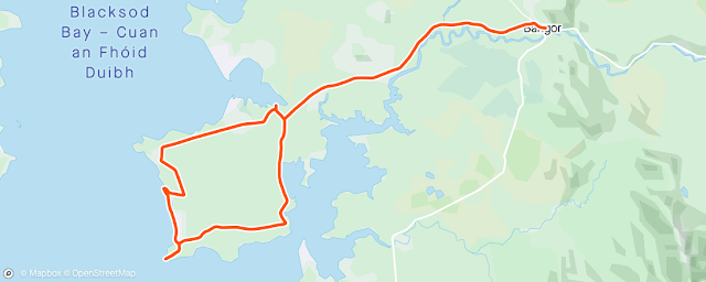
 

Today was my earliest start to any of my coastal runs. I’m out of bed at 5.00am, sneaking out of the room and trying not to wake Maureen and Brian. I had a quick breakfast (weetabix and fruit again) at the B&B, drove the 18km to Gaoth Saile and started my run just as dawn was breaking at 5.54am. Yes this was a mad idea that I had thought about a few days ago. I had realised that the first 20km of my run today would take me on a complete loop around the Doohoma peninsula. So I figured I could get up early, drive to Gaoth Saile and park my car there, run around the peninsula, come back to my car, and then drive back to the B&B in Belmullet. My plan worked out so well that I was in plenty of in time for my cooked breakfast (scrambled egg) at 9.00am. Evelyn at the B&B confirmed that I was the only person ever have two breakfasts in Kemar Guesthouse!

Everyone is smiling this morning and talking about Mayo’s great win in the All-Ireland semi-final last night which ended Dublin’s seven-in-a-row attempt to keep the Sam Maguire cup. The Saw Doctors ‘Green and Red of Mayo’ has been playing on Mid-West Radio and there’s a lovely atmosphere all over Erris.

Brian at Mayo car just before great win over Dublin

 Gaoth Saile (Geesale)

It’s very quiet here at 5.50am as I get out of my car in Gaoth Saile. I think that even at 5.50 in the afternoon things would not be much difference in this remote village. The writer John Millington Synge has connections to this area. ‘The Playboy of the Western World’ was inspired by a "shebeen" in Gaoth Saile, which Synge described as "very rough and untidy". To further emphasise the wild-west image in the village there’s a pub here called ‘The High Chaparral’ (after 1960’s TV series) which caught me by surprise. Nobody under sixty could possibly remember this show!

I’m tackling this Doohoma peninsula today which has a similar shape to the Iberian Peninsula. I knew low tide was at 5.42am so I headed down to the nearby shore and plan to run along the sand. This is not such a good plan as the sand near Gaoth Saile is very marshy and impossible to run (or walk) on. However, I have the alternative of a quiet country road heading west. After about 5k I come to a small crossroads and take a left signposted Radharc na Mara. About halfway down the peninsula I’m able to take a right turn that brings me down to Doohoma (Dumha Thuama) beach. Over 5,000 years ago this whole area was covered by a great forest of oak, yew and pine and there is still evidence on the shore of tree trucks and stumps.

View of Slievemore, Achill from Doohoma Beach

It’s just 7.00am now as I reach this secluded beach. I’m probably lucky that it is low tide as I run along the sand. There’s something special about this area and now I’ve so close to Achill Island. Towering Slievemore is facing me across the bay, almost winking at me and saying ‘see you next month’. Yes its going to tough running around the hills and cliffs in Achill. I’m not sure if I’m looking forward to it.

Translated it says ''He who travels has stories to tell''

I pass a small monument dedicated to Seamus Mag Uidhir (Jim Paddy) who was from Doohoma and travelled all over Mayo on his bicycle in the1930s. I like the inscription on the stone that overlooks the beach. Yes the more you travel the more stories you'll here.


Doohoma Cemetery

Like most of Connacht, this area suffered so much because of the Famine. For years there was no proper cemetery here, so burials took place on the sand dunes. Calls for a proper graveyard were rejected by civil authorities so in 1926 a cemetery was built by voluntary work. Three hundred local men built a sod-wall around the two-acre site. Eventually Mayo Co. Council erected a stone wall around the cemetery and then in 1967 over 100 volunteers built a road from Doohoma village to the graveyard. I'd have to say though, that it is a little disappointing, that there is nothing (that I could see) at the cemetery, explaining this sad but inspiring history.    

At Doohoma Head, SW corner of Doohoma Peninsula


I carry on running south to the very bottom corner of the peninsula and pause again at Doohoma Head (An Ceann Ramhar). There were so many potato pickers from this area who went to Scotland each summer that ships picked them up here at Doohoma Head. As I run along the south-eastern tip of the peninsula I can see across to Ballycroy. At one time a ferry went from Tallaghan Bawn here across the bay. 

There’s a warm breeze following me all day as I loop around the peninsula, and I can’t help thinking of the direct translation of Gaoth Saile which is ‘salty wind’. It’s still only 8.10am when I arrive back in Gaoth Saile after my 22km circle of the peninsula. I still have plenty of time to get back to Belmullet for my second breakfast.

Looking back towards Gaoth Saile and Achill

Back in Belmullet, we take our time. We check out of the B&B and Maureen drives me back to Gaoth Saile to complete today's run. Now it should be a simple 12km run along the west bank of the Owenmore River or the big river (An Abhainn Mor) to Bangor Erris. You could argue that Bangor Erris isn’t really by the coast and perhaps I could have crossed the river earlier. However, I don't think there was any other option. 

Celebrating Mayo's win and my arrival in Bangor Erris

My legs are tired now as I tackle this winding road. What’s keeping me going is knowing that I’m soon to reach another milestone on this adventure. So, at 12.20pm I finally reach Bangor Erris. 

Arrived in Bangor, Co. Mayo.
Now I can say that I’ve run all the way from Bangor, Co. Down to Bangor, Co. Mayo. My journey has been along  the beautiful scenic route and that’s why it’s taken me four years to get here! I calculate that when I left Bangor in Co. Down back in September 2017, I had already run 330k of the coastal run. Therefore, I make the Bangor-to-Bangor coastal section 1,848km. 

Wednesday, 14 July 2021

STAGES 51-54: Maureen&Brian behind Ballyglas Lighthouse

                                                       Stage 51


                                Co. Mayo: Mullet Peninsula: Clogher to Ballyglass Lighthouse

                                                Saturday 10 July 2021

                                                     46.3 km or 29 miles


It was another five hour journey yesterday evening from Bangor, Co. Down but at least this time we have almost a week in the west of Ireland. Last night Maureen, Brian and I stayed in Clogher, in the southern part of the Mullet peninsula in a lovely B&B called 'Bru Chlann Lir'.  Our host Josephine entertained us over the four or five days.

Just like last time I decided on a very early start this morning with a light breakfast (Weetabix and banana) before I started my run. Maureen and Brian opt for the full Irish breakfast at 9.00am and we arrange to meet later at the top corner of the peninsula, Ballyglass Lighthouse. Today I’ve running along the east side of the Mullet Peninsula.


Road to beach near our B&B 

It was the perfect morning as I left the B&B at 6.36am, heading east to a nearby beach, Tra Fheorainn (or Tra Mullach Rua) and then north when I reached the strand. I was able to quickly get onto the country road and still stick to the coast. After coasting around Elly Bay (Ba Oili) I took a right turn (L5235) to Rosbaragh Island. 

I met a local farmer there, Peter who was very willing to chat. I told him how I was so impressed with the beauty of Mullet Peninsula and he agreed. “The last place God made”, he said. I think he was hinting too that God left the best till last! I asked Peter about getting across to Rosbaragh Island but he said it wasn’t possible at the moment with the high tide. When I got to the island itself the causeway was indeed covered so I decided that I would come back later with Maureen and Brian. We did return to complete the job on Monday. (see below)

With Peter, near Rosbarnagh Island

High tide at Rosbarnagh Island


Rosbarnagh (Ros Bairneach) Island 

It’s always nice to do some of the coastal run (or walk) with Maureen and Brian and we returned to the island on the Monday afternoon. Strava recorded our complete circle of the island as only 2.5km but it was tough going with no real path to follow and lots of ditches, long grass and fences to climb over. We were glad to get back again to the causeway and the mainland!

Maureen, Brian and I circled Rosbarnagh Island

Meanwhile on this Saturday morning, running on my own, I kept to the country roads. I coasted around the village of Binghamstown which at one stage was the main centre of population on the peninsula. The village was founded by Major Bingham (not sure if he was related to the North Down Binghams). Bingham didn’t take too kindly when a rival town, Belmullet was built and he erected a large gate across the roadway to stop anyone who took their animals to the Belmullet Fair. They had to pay a toll as they passed through his gate. It became known as an Geata Mhor (the big Gate)

So being the rebel that I am, I avoided Binghamstown and any possible toll charge! In any case my coastal route was much more interesting even if it did mean crossing a rough trail which I spotted as a dotted line on the Ordnance map. Soon I arrived, feeling very thirsty, on the outskirts of the town of Belmullet. I stopped at a small garage, looking for water and the man asked me “what kind of water do you want”. I said, “Water to drink”. He told me he only had deionised water, so I decided to give that a miss and wait until I was able to get drinking water in a shop nearby.

 Railway to Mullet Peninsula:  At one stage it was suggested that the railway line would go all the way to Blacksod which would have connected with trans-Atlantic shipping. However, the local businesses in Mullet were more sceptical and feared that the introduction of a railway line would adversely affect their trading position, putting Ballina within easy reach from the Mullet peninsula.

So after downing a full bottle of drinking water I continued north, following the Ballyglass Road. I kept to that road until I came to a small, staggered crossroads.

Coastal road I took towards Morahan

 The sign said, left for Tipp Pier and right for Morahan which led me down towards an even quieter coastal road. Eventually I arrived back on the main Ballyglass Road and it was a mostly downhill run all the way to Ballyglass Pier. 

Near Ballyglas Pier

I had a wee break at the pier, rang Maureen to tell her where I was, then backtracked and took a right turn, signposted ‘Radharc na Mara’ (view of the sea) which took me on a trail to Ballyglass Lighthouse where Maureen and Brian were there to meet me. It was still only 11.30am so I was happy with today’s run although I know tomorrow’s challenge will be a lot more difficult.


Brian at Ballyglas Lighthouse


Maureen&Brian behind Ballyglas Lighthouse


                                Stage 52


                                Co. Mayo: Mullet Peninsula: Ballyglass to Tra Bheal Doire

                                                Sunday 11 July 2021

                                                     39.5 km or 24.5 miles

At the B&B I availed of the cooked breakfast, poached eggs and tomatoes. I think its over 30 years since I ate any red meat so for me in the morning, its usually eggs of some kind. Maureen and Brian drove me back to Ballyglas Lighthouse to start today’s tough run. The Mullet Peninsula is quite flat with one exception, the northern top part which I happen to be tackling today. 

Back at Ballyglas Lighthouse again

After leaving the lighthouse I’m able to run south on the country road. I don’t risk taking the turn for Poll an Chapaill (stream of the horses) and trying to cross Blind Harbour. Even at low tide that would not be safe. Instead, I stay on the main road and take a right, signposted Tipp Pier. I don’t run down quite as far as the pier but take a left through a farmer’s track climbing up to the top of the headland. 

Bog Lillies along Headland

I follow the coast all the way around, running through boggy fields. It seems to take me ages but I eventually reach Ceann Iorrais (Erris Head) where I had arranged to meet Maureen and Brian again. There’s a small car park here and a wee mobile coffee/snack stand. It’s taken me over two hours to get here and I’m so glad to have a break.

With Helen at Ceann Iorrais (Erris Head)

We get talking to two girls Helen and Ali who are doing their own walking, swimming and running challenge around the peninsula. Helen is commemorating her sister and brother (Tish and Niall Murphy) who tragically lost their lives in a drowning accident exactly twenty years ago. We also get talking to Cathal and Noreen at the kiosk/coffee stand (Cliffside Treats). Noreen had her own personal tragedy when she lost her son, Daniel through a fishing accident. We had seen a commemoration plaque for Daniel on Rinroe Beach a few weeks ago and coincidentally it was Stephan (landlord from Yellow Rose B&B where we stayed) who found Daniels body after he was missing for days. 

Brian & Maureen during loop walk at top of Peninsula

Erris Head Loop Walk (Lub Cheann Iorrais)

I noticed a red dotted line on the Ordnance survey map to indicate this path which goes from the car park up to the very top of the peninsula. It means that Maureen and Brian can join me along this 5km stretch and I appreciated walking (rather than running) for a few miles.

After we reach the top I say goodbye to Maureen and Brian and I carry on, heading south on the coastal headland. As time passed I really struggled along here especially as I realised I had a long way to go on such a hilly and uneven terrain. This was tough going but it did bring me to the close to Eagle Island (Oilean Tuaidh).  

Eagle Island - closest point from Mullet Peninsula

   A Goat’s Song: I’ve just been reading Dermot Healy’s book ‘A Goat’s Song’ and he refers to this particular area. It’s the perfect novel to read if you’re visiting the peninsula. The main character in the book had a house in Aghadoon and he refers to Eagle Island and its flashing light from the lighthouse “three times flashes, count to eight and three times more”. At night from our B&B (10km away) we can see the flashing Lighthouse, but Brian and I counted to eighteen (not eight) each time before it flashes again! 

View of Eagle Island from Dun na mBo

At Dun na mBo - rock, rock and more rock
I stay by the coast and finally arrive at Dun na mBo (the cattle fort). In older times this was some kind of strategic fortress. There’s a blowhole here where the sea water is pushed forty metres up from sea level and sometimes stones are scattered around. I’m glad now to be back on a country road again (and hopefully no more hills to climb today). I follow the road south and take another right turn (not named at all) that brings me down onto the strand.
Shortcut from Dun na mBo to Annagh Head

 It’s low tide now and so it means I can take a shortcut along a beach that eventually brings me onto the road towards Annagh Head. This piece of luck has encouraged me and although I’m tired and very thirsty I’m feeling more positive. 

Annagh Head (Ceann an Eanaigh)

I run all the way down to the end of the peninsula at Annagh Head. Here on the west side of the Mullet Peninsula are the oldest rocks on mainland Ireland, 1,753 million years old. In the book ‘A Goat’s Song’, people light a bonfire at Annagh Head to celebrate St. John’s Night (23rd June). However,  today I’m the only person here.

 I leave Annagh Head and backtrack along the road. Soon I notice sand dunes on my right so I climb a fence and suddenly find myself on a lovely beach. I’m now on the sandy west side of the Mullet Peninsula. I can see Carne Golf links (often ranked as Ireland’s favourite by those curious enough to venture this far west). 

It’s not all easy along the strand but it is mostly beaches (or sand dunes) and I eventually arrive on Tra Bheal Doire. It’s 6.00pm and it has been a long day!

Relieved to arrive at Tra Bheal Doire


                                  Stage 53


                                Co. Mayo: Mullet Peninsula: Tra Bheal Doire to Tra Deirbhile

                                                Wednesday 14 July 2021

                                                     17.2 km or 10.5 miles


Yes I completed this section on the Wednesday having already completed Stage 54 on Monday 12 July. Maureen and Brian joined me for the first two miles which was really just a nice walk on the beach. Even when I left them, it was mostly a 10 mile run along the strand on the west side of the peninsula.

Interestingly we followed some of the route for the Erris parkrun (because of Covid restrictions the parkrun hasn’t started back yet). At Blacksod Pier on Monday morning I met the organiser of the Erris parkrun, Padraig Brogan and I promised I would come back when it restarts. Padraig insisted that I come into in his office later that day and presented me with a parkrun cup and an Erris parkrun keyring. In January 2023 I was shocked to hear the very sad news that Padraig had passed away. I was so privileged to have met such a lovely man. I still carry the Erris parkrun keyring with me, attached to my car and house keys. I will keep my promise to return some day and do the parkrun in Padraig's honour.

Padraig presenting me with Erris parkrun coffee cup 

Sinead Diver: Speaking of running I realise I’m not too far away from where Sinead Diver grew up. Sinead is running in the Tokyo marathon in a few weeks. She only started running in 2010 at the age of 33 after she moved to Australia. Under normal circumstances she might have been home in Corclough and might have even joined me, but I’ll excuse her today as she’s running at a much bigger event in Japan! And an update to this story: Sinead finished tenth in the Olympic Marathon in August 2021 in a time of 2 hours 31 mins. More recently in December 2022 she knocked another 10 minutes of that time in the Valencia Marathon with 2 hours 21 mins. That time would have won her every Olympic Marathon. Not bad for a wee girl from west Mullet.  

 Inish Gluaire, ‘Children of Lir’ & other legends

We can clearly see Inish Gluaire (The island of Purity) which has a connection to the story, ‘The Children of Lir’ based on the old Irish legend about the four children who were turned into swans. Inish Gluaire is where, according the legend, the swans/children had to spend the final 300 years as part of their punishment.

There is another even stranger and scarier legend that the medieval writer, Giraldus Cambrensis (1146-1223) tells about Inish Gluaire island. It says that human corpses don't decay on the island and ‘if deposited in open air, they remain uncorrupted; relatives can recognise their parents, grandfathers, great-grandfathers and all their ancestors’. Not so sure if I want to believe this. It reminds me a little of the ‘White Walkers’ in Game of Thrones which would give anyone the creeps!

On western beach 

Anyway, back to July 2021. I say goodbye to Maureen and Brian and continue along the beach. There’s a strong south-west blowing in my face but at least there are no hills today. Also, the tide is going out which does help me as the day goes on. However, soon I come to a stretch of the coast that’s quite rocky. There are no sand dunes here on this (one mile) section and the local farmer has done such a brilliant job with his barbed wire fencing, meaning I can’t even run in the fields. I have no alternative but to climb through and over the rocks and stones which seems to take ages.

Great to have this long beach to run on
 However, once I’ve tackled that rocky section, I have a beautiful sandy section ahead. The beach is about 3.5km long and I recognise it as I was here at this exact spot yesterday with Maureen and Brian. There are lovely views from here across to the Inishkea islands.

Brian loves the waves

Inishkea Islands

I’ve had a fascination with these two islands for about 20 years, even before I knew exactly where Inishkea was. My curiosity came from the fact that these twin islands seemed to buck the trend as regards the population decreasing after the famine. The potato blight never reached Inishkea. The islanders also had a great skill and tradition of fishing. In the early 20th century when other areas had high emigration a Norwegian whaling station brought employment to Inishkea. However the presence of the station caused tension between the two islands, because it is said that all the jobs went to the south islanders and the north islanders were left with just the foul smell! 

On our way to Inishkea South Island


Brian gets a chance to drive the boat

Although Inishkea avoided the famine and had very little emigration the islands were met with a terribly tragedy in 1927 when a massive storm claimed the lives of ten fisherman. After this disaster, the islanders realised themselves that it was no longer safe to be fighting the hazardous Atlantic winds.

Deserted village on Inishkea Island

Maureen, Brian and I were delighted to be able to visit Inishkea South on the Tuesday. Yes I resisted the temptation to run around the island although it would have been quite an easy challenge. For our trip we were blessed with a beautiful day and a lovely calm see crossing. The island (Inishkea South) was everything I wished for. We had four hours to explore it all and enjoy our picnic in this magical Atlantic isle! The ruins of the old houses still remain and it was easy to imagine hundreds of villagers living here just a century ago.


At the tower on Inishkea Island

Meanwhile I continue my Wednesday run on the west side of the Mullet mainland. I keep an eye on the Inishkea Islands across the sea as I run to the very end of the long beach. I then take a trail that joins up with the country road and after a steep climb, pass through the village of Glais. 

From Glais looking back to beach I ran on 

After the great storm in 1927, most of the Inishkea islanders were relocated to this area. I also noticed a place nearby on the map called ‘An Baile Nua’ (new town).

 For me it’s the perfect downhill run to my finish line at the pier (An Port Mor) and then along the strand to Tra Deirbhile. Today was probably one of my nicest runs so far, mostly beach and perfect ‘sand for the feet of the runner’. Across the sea I can clearly see the hills of Achill Island. Dark Slievemore is towering above and the huge cliffs of Croaghaun are leaning into the sea. It’s going to be tough going when I get to Achill. However, that’s a run for another day.      


                                Stage 54


                                Co. Mayo: Mullet Peninsula: Tra Deirbhile to Clogher

                                               Monday 12 July 2021

                                                     13.7 km or 8.5 miles

I completed this section in the early morning, skipping the cooked breakfast again and arranged to meet Maureen and Brian later on at Tra Deirbhile. I started at the B&B (Bru Chlann Lir) near Clogher and completed this section clockwise (with the sea on my left) for a change. I had two tough days of running so I was struggling to get moving at all today. The weather didn’t help as it was a dull morning. Just as I did on Saturday, I headed down to Tra Mullach Rua. When I got to the beach I ran south this time and then later I re-joined the main road. 

At Blacksod Pier with Gov Minister & officials in background 

As I was running down to Blacksod Pier I noticed a group of people gathered there. I thought that maybe word had got around that I was running around the Mullet peninsula. Unfortunately, the small crowd were not there to greet me. They were waiting for a government minister, Jack Chambers to arrive as there are plans to open up the Blacksod Lighthouse as a museum. I got talking to a freelance journalist, Tom Reilly (from Takemeschnap) who, having time to kill before the minister arrived, did a video interview with me. I told him my story and later I was able to share the video link on my Facebook page.  

At Blacksod I spot a memorial garden nearby with the names of hundreds of emigrants who left Mayo for America after the famine. It was James Tuke, a Quaker who realised that local resources could not sustain such a large population. Tuke even travelled to Canada and the US to get in touch with potential employers and find suitable locations for the emigrant families. The scheme was successful but only lasted for two years (1882 to 1884) following opposition from Parnell’s IPP party and the Catholic bishops.

There is so much history here on the Mullet Peninsula and as I’m running around the coast of Ireland I’m always conscious of those who have suffered in various battles or disasters. 

However, when something happens in more recent times it’s more difficult to refer to it. On 14 March 2017, a rescue helicopter had completed the medical evacuation of an injured fisherman 250 kilometres west of Blacksod. On returning to the Mullet peninsula the aircraft crashed into a high island called Blackrock Island, about 17km west of Mullet.

(On our boat trip to the Inishkea islands we actually saw the cone shaped Blackrock Island from a distance).

View of Blackrock Island from boat trip to Inishkea

Sadly, all four crew members on board, Dara Fitzpatrick, Mark Duffy, Paul Ormsby, and Ciarán Smith died. Although Blackrock Island was registered in the craft's GPS mapping system it wasn’t registered on the aircraft’s EGPWS system.

Captain Shivnen spoke at the service of Paul Ormsby whose body was never recovered. He quoted a verse written by Fergus Sweeney (grandson of the afore mentioned, Maureen & Ted Sweeney) that Fergus had written for a previous memorial at Blacksod lighthouse. 


“You are a rumble in the sky: you are a flickering star: you are hope in the darkness’’

Plaque at Blacksod Pier in their memory  


 The D Day Landings

It’s amazing that Blacksod and the Mullet peninsula has a connection to the D Day Landings. In 1944 Maureen and Ted Sweeney, who were based at the local weather station in Blacksod Bay, were first to forecast a severe Atlantic storm, which led to a change of plan in one of the world's biggest military operations. Maureen Sweeney is now over 100 years ago and was honoured in 2021 at Tí Aire nursing home in Belmullet where she lives. She received a ‘USA House of Representatives’ award that is very rarely given. Maureen likes to tell the story about that day in 1944.

‘A lady with a distinct English accent requested me to ‘'please check. please repeat’’. We checked and rechecked and the figures were the same both times. They had it all worked out to the nearest detail, but our weather report put the first spoke in the wheel. They would have gone ahead and the invasion would have been a complete disaster. There they were, with thousands of aircraft which couldn't tolerate low cloud. They could arrange everything, but they couldn’t pre-arrange the weather! We were delighted we put them on the right road. We eventually had the final say.'


Another interesting fact about Blacksod Bay is that Tom McClean arrived here in July 2019 after rowing across the Atlantic, becoming the first man to do this single handed. It took him 70 days from Newfoundland.

As the government minister arrives at Blacksod Pier, I decide it’s time for me to leave. I backtrack up the road and take a left towards Tra Deirbhile. It’s quite foggy along here so not much to see at the Deirbhile’s Well viewing point. Legend says Saint Deirbhile travelled here to this part of Mayo to escape a lover. Yes you can’t get much further away than this corner of the Mullet Peninsula! I keep running until I see a sign for Tra Deirbhile. It’s a nice south facing beach and I’m glad to soak my feet in the salty water until Maureen and Brian arrive.

Total coastal circle of Mullet Peninsula: 116.7km or 72.5miles