STAGES 68-69 Louisburgh to Tully Cross, Connemara:
Louisburg, Co. Mayo to Leenane, Co. Galway.
Easter Saturday 16 April 2022
31.28km or 19.44miles
 |
| Louisburg to Leenane |
I’m mainly running on my own this weekend, but my support team, Maureen and Brian have joined me. They are going to walk part of the first stage with me along the infamous ‘famine road’ from Louisburgh to Delphi. (you’ll read the history behind that walk later). Since my last coastal run, I’ve completed my second official marathon. It was a disappointing day for me over a flat Manchester route in perfect weather conditions. I reached the half-way point in a time of 1 hour 47 minutes, but my finish time was 4 hours 12 mins. Maureen thinks I might be more suited to coastal running when I can stop along the way, chat to people and take some pictures. Maybe she’s right and yes I prefer this type of casual running.
 |
| Leaving Louisburg - Maureen, Brian & Colette |
Maureen, Brian and I drove down from Bangor yesterday (Good Friday) and had the pleasure of staying with Maureen’s cousins, Collette and Bartley O’Malley. No doubt they are related to the famous Grace O’Malley (Granuaile, the pirate queen). The O'Malley sheep farm has the most beautiful rural location in Laghta Eighter about 6km SE of Louisburgh. Collette is the perfect host and we are lucky to a have a room with a view – and a beautiful sight to wake up to, seeing Croagh Patrick from our bedroom.
 |
| Collette, Brian & Bartley with Croagh Patrick's peak behind |
In the morning Bartley is already out on the farm but Collette prepares a delicious breakfast for us. Just before we leave the farm we hear the lovely sound of the cuckoo. It's the first of the season but one of over 4,000 who have migrated from Africa to Ireland.
 |
| Ready to begin our long walk from Louisburg |
 |
| Valerie & Michael |
Today we are really re-enacting a famous but tragic event in Ireland’s history.
 |
| Croagh Patrick watching over us as we begin our walk |
The Doolough Famine Tragedy
On 30 March 1849 during the Irish Famine a large body of starving people gathered in Louisburgh seeking food donations from the relieving officer. Apparently the officer didn’t have ‘his books’ with him in Louisburgh so he informed the hungry locals that they would have to apply for food on the following day. However, the next day, officials had moved onto Delphi Lodge, ten miles away and that was where donations would be made available. So in the morning, a procession of men, women and children made their way on foot across the 16 km mountain route to Delphi.
When the families arrived in Delphi, food was not forthcoming and they had to make their way back to Louisburgh again, tired and hungry. On the return journey many died. Seven bodies were discovered the next morning and nine other people never returned home.
Every year there is an annual charity walk in May along the Louisburgh-Delphi route to commemorate those who suffered and perished. The walk also draws attention to human-rights abuses around the world. Archbishop Desmond Tutu, Chernobyl children and Kim Phúc (famously photographed as a girl running naked during the Vietnam War) are among those who have walked the walk. There are two memorials of the famine on the road – one a simple stone and the other quoting Mahatma Gandhi. “How can men feel themselves honoured by the humiliation of their fellow beings?”
 |
| Monument with Gandhi's profound quotation |

These type of abuses still continue in countries like, Syria, Yemen, Ukraine and Israel. Today, these words have never been so apt. As we watch the destruction in the world, Gandhi’s words are still relevant today.
However, there is an uplifting connection between those who perished in Ireland and a Native American Tribe who suffered a similar fate around the same time. Sixteen years previously in 1833, 20,000 people from the tribe of Choctaw were forced to walk their own 500-mile Trail of Tears to new land in Oklahoma. Thousands died on the way and more perished while struggling to set up homes in the new ‘Indian Territory’. Yet despite their own suffering, Choctaw Elders somehow received word in 1849 that people were starving to death in Ireland. The native tribe were able to collect $170 to send to Ireland for famine relief. An amazing gesture on their behalf.
More than 170 years later, Ireland has rightly repaid the debt, helping to raise more than two million dollars for Native American tribes and nations which have been hardest hit by the coronavirus pandemic. An article in the 'New York Times' described the repayment perfectly, ‘Irish return an old favor’. The Choctaw word for a selfless act is ‘iyyikowa’—it means serving those in need and the Irish word is ‘neamhleithleasach’.

 |
| New born lambs |
As we’re walking along the Doolough road, we can only imagine what a horrific journey this must have been for our starving ancestors. At least today we have a modern road to walk on, that conveniently cuts through the narrow valley, but in 1849 these poor people had to try to figure out the proper route through the bog and mountains.
Having said all that, it was still a long walk for Collette, Maureen, Brian and I. It was 13.2km (or 8.2 miles) from Louisburg to the Doolough Memorials against a very strong southerly wind. At least the rain held off! As we arrive at beautiful Doolough valley the mountains are towering above us. Ben Lugmore (803metres) and Mweelrea (814m) are on one side and Barrclashcame (772m) is on the other. All three peaks are higher than Croagh Patrick (764m). Doolough (black lake) also takes up most of the valley so in 1849 it would have been a treacherous, wet and boggy route through the hills.
 |
| Arrival at Doolough after 13km (8 mile) walk from Louisburg |
This area is also an ancient part of Ireland. On our walk from Louisburg we passed through the village of Cregganbaun where there is a wedge tomb which dated from 2000 BC. Hard to imagine what kind of people would have been living in Co. Mayo over 4,000 years ago.
Maureen, Brian and Collette drive back north to Louisburg and I begin running south along the narrow road with the lake on my right-hand side (Doolough Pass Road). I pass Delphi Lodge; yes the same lodge that the families were turned away from in 1849.
 |
| I think this could be Ben Lugmore |
Today Delphi is
known as an adventure centre, ‘over 20 fun filled water and land based
outdoor activities designed to challenge and reward all ages and abilities’. With consecutive coastal runs this
weekend, I think I have endured enough challenging activities!
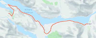
I reach Killary Harbour, Ireland’s only fjord and head east along the main road until I come to Aasleagh Falls. This is where the Erriff River reaches the sea at Killary.
 |
| Aasleagh Falls on the Mayo/Galway border |
Just
south of the Falls I see the sign ‘Welcome to Co. Galway’. I’ve covered a total
of 743 km of the Co. Mayo coast which is quite close to the official Neilson
& Costello (Trinity College professors) figure of 729km. The Mayo coastline
still doesn’t beat Donegal which was 930km, very close to the
official Neilson & Costello figure of 938km. (The Trinity College pair did not
include islands in measuring the coastline)

Co. Galway also has quite an extensive coastline too, 642km, according to Neilson & Costello. Still, it’s great to finally reach my native county and I’ll be following the Connemara (west Galway) coast for the next few months. I can now see the mountain, Devils Mother in front of me. (Strangely the Irish name for it is ‘Magairli an Deamhain’ which translates as the ‘demons testicles’!).
 |
| First 'person' I see in Co. Galway |

Finally, I reach my finish line for today, the village of Leenane. It’s perfect timing as Maureen and Brian arrive shortly and we head straight for ‘The Field’ pub which became famous in the 1990 film. It is busy inside but we’re lucky to find a cosy spot in the corner. Outside, the rain, that has been threatening for a while, pours down.
Stage 69
Co. Galway: Leenane to Tully Cross
Easter Sunday 17 April 2022
34.41 km or 21.38 miles
“If people never did
silly things, nothing intelligent would ever get done.” ―
 |
| First part of run from Tully Cross to Glassillaun Beach |
Today was one of those days where things seemed to go from bad to worse for me. For a start my hip has been giving me grief since Wednesday and yesterday’s walk and run hasn’t helped. Then I decided to have some porridge and poached eggs for breakfast. Not a great combination if you’re going on a long run! Thirdly I was given wrong directions by a young man in the village. I asked him the way to Lettergesh Beach, and he sent me down towards Tully village. I had covered 4.5km before I arrived back at the hotel where I started my run, a half an hour earlier!
 |
| When you're lost and this is the only person you meet! |
Then finally after getting on the correct road, I followed a sign that said ‘Beach’ that I thought (wrongly!) would be bring me down to Lettergesh strand. I should point out that a lot of people reading this would have heard of Lettergesh as it was used in the famous horse racing scene in the 1952 film, ‘The Quiet Man’. Anyway, as I was running down this long narrow lane I was thinking to myself, there is no way John Ford and his production crew came along here.
 |
| I wish I hadn't followed this sign |
My suspicions were correct and to be honest there wasn’t even much of a beach at the end of the lane. I then struggled along the rocky and slippery coast as the rain was coming down. It was a miracle that I didn’t fall over at some stage along here. I eventually I made my way back onto the country road and after a few miles I saw a clear sign pointing down to Lettergesh Beach.
 |
| Lettergesh beach at last |
Yes, this beach was worth waiting for. Strangely Lettergesh is not named on the Ordnance Survey map, but it is on ‘google maps’. It’s divided into three parts and best to get here at low tide as I managed to do (my only bit of luck so far today!). Otherwise, you might not be able to get around the first section. As I was running along the strand, I was thinking that nothing has changed in the seventy years since they made 'The Quiet Man'. The beautiful beach, the countryside and surrounding hills are exactly the same. They could still make the same horse racing scene today.
 |
| We all came back later - Lettergesh with Mweelrea behind |
There are two wide streams with strong currents in the main beach that are quite difficult to cross. In the movie, ‘The Quiet Man’, the horses, with their long legs, gallop through these rivers. It was not so easy for me to get through them. I had to pick a spot by the cliff to manoeuvre around the first stream and then I walked straight right through the second one, hoping I wouldn’t sink in the soft sand.
 |
| Another wide stream to cross |
The rain is coming down again but I’m able to continue along the shoreline but then have to rough it across a few fields before eventually reaching another beautiful beach, Glassillaun. It’s been tough today and I still have a long way to go. I briefly meet three different families in this area, a French, Polish and an English couple. Maybe all the Irish are wisely indoors today or are we, as a nation, getting a little lazy?
 |
| Perfect white sand on Glassillaun with dark Mweelrea behind |
 |
| Glassillaun Beach |
From the carpark at Glassillaun beach I come to a T junction and take a left turn. I hope I’m going the right way but worry that this narrow boreen is going to come to a dead end. Luckily for me the lane conveniently hugs the coast around what’s called, ‘Killary Bay Little’.
 |
| Second part of run from Glassillaun to Leenane |
 |
| View of Inishbarna Island from Rossroe Pier |
A famous philosopher Ludwig Wittgenstein, a former soldier who survived WW1, lived in this remote area in this area 1948. The Austrian wanted a simple life in Killary. He found peace and a fascination with nature here under the shadow of Mweelrea (the bald eagle) where he could put his thoughts together. “We are asleep. Our life is a dream but we wake up sometimes, just enough to know that we are dreaming.”
 |
| Killary Coastal path - only some of it was like this |
Just up from Rosroe Pier is
a signposted walk. I spotted it as a dotted line on the OS map and I know I can
follow it all the way along the southern shore of Killary Harbour. It is rough
going at the beginning, impossible to run on and the path sometimes disappears.
It is also quite a dangerous trail in parts (especially on a wet day like today)
with steep descents down to the narrow fjord. I read that this trail is called a ‘famine relief’ road.
I think that means that it was built for no other reason than to justify rewarding
the local hungry people in the area, but making sure they did something to 'earn' their reward. This was a common occurrence during the
famine; roads or walls been built that served no purpose.
 |
| And some parts of the path were like so |
I spot lots of large shellfish beds below me in Killary Harbour. There are mussels, clams, and oysters. On Friday night, our host Bartley told us he had some oyster beds along here. Soon the trail improves and I’m able to run again. Shortly I meet a jolly group of about fifteen walkers. They are called the ‘Wayfarers’ and they’re a Dublin-based hiking and mountaineering club.
 |
| Wayfarers Hiking Group |
Despite the damp weather they seem to be in good humour and cheer me up too. I think they’re planning to do a loop walk and will return to Leenane by Lough Fee.
 |
| View across northern shore of Killary |
 |
| And a waterfall on southern side |
Eventually the rough path that I’m running on turns into a much easier country road which I follow all the way until it joins up with the N59. The sign on the main road says, Leenane 7km. It’s mostly downhill towards my finish line but just as I’m feeling smug and confident, the sky darkens, and the rain comes down again.
 |
| At last - tired and wet but job done! |
This time it’s more than just a shower. It’s relentless for about half an hour and I arrive in Leenane soaked to the skin. I'm so glad to see Maureen and Brian and I enjoy a tasty bowl of seafood chowder. After lunch we go to the Forge Craft Shop and Maureen buys me an Aran sweater. Hot soup and a warm Aran jumper, just what the doctor ordered!