 |
| STAGES 49-50: The five Stags with one slightly hidden |
Stage 49
Co. Mayo: Beal Deirg to Annie Brady Bridge
Saturday 12 June 2021
‘’But now if anybody says anything about war or even fight, I will just run and run and run’’ Kenule Beeson, Nigerian writer.

Readers of the Irish Times voted this Erris region ‘the best place to go wild in Ireland’ and I’m tempted to strip off and go a bit wild myself. However, it’s a bit cooler and duller in this part of Mayo and nowhere near the 26 degrees forecasted in some parts of Ireland today. It had been a five-hour journey yesterday evening from Bangor, Co. Down to reach this area of Mayo. Maureen, Brian and I are staying in the Yellow Rose B&B in Belderrig and our hosts Eileen and Stephen looked after us over the weekend.
 |
| Just out - my new Book, Ulster Coastal Run - but today I'm in Connacht |
I decided on a very early start this morning with a light breakfast of Weetabix and banana. Stephen at the B&B even got up and kindly made me tea and toast before I started my run from his house at 6.26am. Maureen and Brian opt for the full Irish breakfast at 9.00am and we arrange to meet later.
I’m feeling confident about my fitness as I’ve done a few long runs in the last few months in preparation for this weekend. In addition, I completed a 50k (31 miles) race at Down Royal Racecourse just two weeks ago with a time of 4 hours 55 minutes. That involved running seventeen times around the racecourse. In horseracing terms, that’s 248 furlongs - at least there were no fences to jump over! I’ve also recently had my second Covid vaccine so I should be good to go today.
I take the quiet country coastal road (just outside the B&B) from Belderrig to Porturlin. I wondered why Eileen at the B&B called it the ‘high road’ but I quickly found out as I seem to be climbing for the first couple of miles after I left her house. In fact, the story of today was all about hills. My Strava results tells me that my total elevation today was 1,818 metres – by far the highest of any stage I’ve done so far. It’s a 13km run to Porturlin and I have this narrow road to myself, only meeting two vehicles along the way.
 |
| Sheep on Porturlin High Road - blocking my way |
However, I did have my road blocked by
sheep at one stage and there was no room to overtake them. I must have run
behind them for a good 2km – the faster I went, the faster they went! I felt
particularly sorry for the young lambs trying to keep up with their parents. Eventually
I was able to steer all the sheep into a gap in a forest and continue my run.
When I arrive at Porturlin (or Port Durlainne) it’s still very quiet. There is evidence though that this is a proper fishing port with boats of all sizes here in this wee harbour. Mackerel, herring, salmon, cod and pollock are the main catches here. (Later back at the B&B I was able to enjoy some of this tasty mackerel for dinner).
 |
| Porturlin Harbour |
 |
| Watching out for drug smugglers |
At the pier I have to make a decision,
whether to stick to the country roads which would have taken me a few miles
inland or follow the direct (over the headland) route towards Portacloy. As the
weather was still quite dry I decide to stick to the coast. It was a long steep
climb up the hill and as I got higher I can feel the strong Atlantic wind on my
face. The beautiful views back down to Porturlin harbour made it all
worthwhile.
 |
| View from top of Porturlin headland |
 |
| View back down to Porturlin Harbour |
 |
| Cliffs near Portacloy |
 |
| Approching Portacloy Beach |
The cliffs are spectacular along here and after a lot of hard climbing I can eventually see the secluded Portacloy beach below me. I descend slowly and on the strand I stop to chat to a young family who have the whole place to themselves. It turns out that they’ve camped here over-night – what a beautiful beach and view to wake up to! The couple tell me that they’re originally from Poland but living now in Ballymena, Co. Antrim.
 |
| Oliw and her family on Portacloy strand |
 |
| Portacloy: perfect beach to wake up on |
I carry on running on the other side of the beach, climbing again until I see the marked Carrowteige Loop. (Bhinn bhui or yellow cliff loop). On the ordnance survey map this part of the coast has a red dotted line which indicates a walking trail. Just west of the beach I cross over a stile and then there are small wooden markers, every 50 metres or so, all the way around the headland. After leaving Portacloy I take a detour off the path to the top corner of the peninsula and spot a huge stone Eire sign on the grass beside the cliff top.
 |
| EIRE sign no. 63 was on further |
These big ‘EIRE signs’ were made of rocks during
WW2 so that aircraft flying overhead would know they were entering Ireland, a
neutral country. This Eire sign even has the no.
63 beside it. (There were 83 in total all around the coast of Ireland erected
during WW2).
I get back onto the
Carrowteige Loop. It’s tough going now with a lot more climbing over the
bogland. However, when I eventually reach the top there are amazing views out
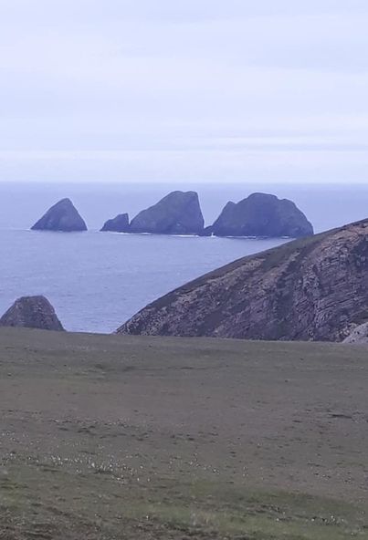
into the Atlantic Ocean and now I can clearly see the famous stags of Broadhaven.
In my previous
coastal run from Rathlachan to Belderrig I could see these tall sea stacks in
the distance, so I was looking forward to getting a much closer look. These five massive rocks rise out of the
sea steeply to about 100 metres above sea level. All the stags have different
names. The highest and central one is called Donal O’Cleirigh (for some reason)
and apparently one of the tall rocks is bisected by a long narrow cave.
Later I see a small rocky inlet in the sea and remembered that I’d read about an island called Pig Island, named so because it’s shaped like a pig. I don’t think this is it and anyway when I showed Maureen the picture she said it looked more like a hippopotamus than a pig!
 |
| Island that looks like a hippopotamus or crocodile |
I see
another a high island which is called Oilean Mionnan (Kid island). The Ordnance
Map says it rises 86 metres above sea level. I read that in summer flocks of
sheep graze freely on the island. Not sure how they could even get there! Not
far from Kid Island are three more tall rocks or stacks, the Parson 30 metres
in high, the Hag 70 metres in high and the Buddagh 80 metres in high. Now I can
see the Belmullet Peninsula across the bay. It looks like a long stretching
island from here up on the cliffs and for a few minutes I was confused as to
what island it could possibly be.
 |
| Remote secluded beach |
I don't meet anyone else along this Carrowteige loop even though it’s quite a nice June
morning and a Saturday. I feel like I’m the only person on another planet. Even this dark
brown landscape of bogs and cliffs looks slightly lunar!
I had arranged to meet Maureen and Brian on Rinroe strand, near Carrowteige and I was looking forward to a good rest. It’s 11.00 am now and I’ve run about 35km (22 miles) and already climbed 1,700 metres today. This is the perfect place to have a wee break. Rinroe beach along with Portacloy Beach (see earlier) have both been recognised for their ‘clean environment, excellent water quality, natural beauty’ and has been awarded a Green Coast Award. To cap it all, this beach is safe for swimming too, although today it’s still too cold for that.
 |
| With Rinroe beach behind |
 |
| Brian likes the boat |
 |
| Sitting on Lobster Pot on Rinroe Pier |
I run on the beach for a few miles (perfect sand for the feet of the runner). I had earlier checked the tide (low tide was at 2.00pm) which worked out perfect for me as I was able to take a short cut across to Rossport (Ros Domhach) peninsula. There was just a shallow stream to cross over (anyway, nice to get my feet washed!) but I was very happy to arrive on the other side. Soon I was able to follow the coast all the way around the peninsula until I came to Rossport Pier.
Rossport and Shell Gas Pipeline
I first heard about Rossport about fifteen years
ago when five local men were jailed for refusing to allow the oil
company, Shell access to their lands. Shell, with permission from the Irish
government proposed to lay a high pressure, raw gas pipeline through the village and insisted that the pipeline was designed to the highest
engineering standards and was safe.
However local people disagreed and protested. Five men, known as the ‘Rossport Five’ were jailed for 94 days for their refusal to obey a High Court order forbidding them from obstructing Shell's construction of the gas pipeline through their lands. Following a review, and after the men were freed from three months in jail, Shell agreed to re-route the pipe to move it further from the men's land.
 |
| Rossport: Shell still not popular in this area |
Admittedly Shell didn’t have a great history in protecting the environment in other countries. They were criticised for causing pollutions and some alleged human rights violations in Nigeria. Kenule Beeson was a famous Nigerian writer and led a campaign against damage to the environment in Africa. Despite his non-violent campaign (see also his words/quotation at the beginning of Stage 49) he was executed by the military dictatorship in his own country. Meanwhile in Mayo in 2018, Shell exited the project, selling its ownership stake to Vermilion Energy.
I continue running, leaving Rossport Pier and join a country road with the sea on my right, as always. I take a right turn at a couple of T junctions and finally arrive at my finish point at Annie Brady Bridge. With a combination of tough steep hills and soft boggy surfaces today has been one of my toughest runs so far.
Stage 50
Co. Mayo: Annie Brady Bridge to Belmullet town
Sunday 13 June 2021
My whole body is suffering today and I’m not as quick to jump out of bed this morning. I avail of the lovely breakfast that Eileen and Stephen have cooked us at the Yellow Rose B&B. After we check out Maureen and Brian drive me back to the Brady Bridge to start today’s run. There aren’t many towns or villages around here so it seemed a good idea to pick this bridge over the Muingnabo river to finish yesterday and start today. However, the bridge itself is not that clearly marked and it’s also difficult to find via Sat Nav. Yesterday as I waited on the bridge for Maureen and Brian a man stopped his tractor to see if I was ok. ‘’I thought you were going to jump in’’, he said. (I don’t think I would have had the energy.)
 |
| Ready to start Stage 50 |
History of Annie Brady Bridge
During the Great Famine and before the bridge was built, this
river crossing became a well-known, but sad parting point between the emigrants
and their remaining families. Sometimes the river flooded and with strong
currents, it swept away cattle and made it impossible to cross. Annie Brady was
the wife of the Inspector of Fisheries for the area and noticed these sad
scenes. She decided to raise money to build a bridge at the site to help
people to travel further with their loved ones. The bridge was built in 1886 but
swept away by a great flood in 1933. It was then replaced by a new structure that's still there today.

At 10.50am I start today’s run from the bridge. I find the first 4k out to the main road tough at times. Yesterday’s exploits are taking their toll and I’m wondering will I make it all the way to Belmullet. I reach the main road and follow it for about a mile before taking a right turn towards Pullathomas (Pholla a tSomais).
 |
| Taking a right turn to Pullathomas |
At Pullathomas (yes hard not to think of a children’s tank engine!) there is a hostel and a pub. However, with Covid restrictions still in place both establishments are closed and there is absolutely nobody about today.

The pub
here is called McGraths and this area also featured strongly in the Rossport
Shell protests. There was a stand-off with about forty locals and twenty Garda on the
land of Paddy and Bridget McGrath, the owners of the pub. The McGraths also had land down at the estuary near the
proposed Shell pipeline. Two of the
‘Rossport Five’ were also called McGrath so I presume they were all related.
 |
| Hopefully the Hostel will reopen soon |
I carry on along this country
road. My legs are moving better now and I’m pleasantly surprised that I can do
any running at all today after yesterday's exploits. I do, however, walk up the hills, telling myself that
this is the ‘sometimes walking’ part that I refer to on the front cover of my
book.
 |
| Looking back across to Rinroe beach |
I can see the pier at Rossport,
across the bay where I was yesterday and also Rinn Roe beach in the distance. Over a
hundred years ago the government thought
about constructing a bridge across Sruth Fada Conn Bay from here to Rossport.
The estimated cost at the time was over £1,000 (a fortune in those days) but it
never materialised.
Looking west in the distance I can clearly see the Ballyglass Lighthouse on the Mullet Peninsula. I pass through another quiet village called Inver (an tInbhear) as the road meanders around. Eventually I arrive back on the main Belmullet (Beal an Mhuirthead) road and shortly after this I take another coastal detour down to Gortmelia Strand. Even though it was low tide, this sand was very marshy and not at all good for ‘the feet of the runner’. I decide to abruptly come inland, crossing a farmer’s field and joined a trail that led me back to the main road.
 |
| Strange seeing a sign for Bangor in west Mayo (Bangor Erris) |
I struggled on the last few miles into Belmullet but I was satisfied that I had achieved what I set out to do over the weekend - even if it had been more difficult than I realised. I was so glad to see Maureen and Brian there to greet me on the pier in Belmullet.
 |
| And I finally reach the Belmullet Peninsula |