STAGES 61-62: Achill, Co. Mayo:
 |
| With Anne - at Guesthouse in Keel |
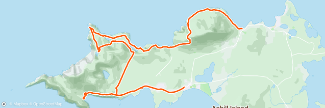
Stage 61: Co. Mayo: Achill: Doogort to Keel
Saturday 25 Sept 2021
36.73km or 22.8miles
(Elevation gain on my watch for today said 1,587 metres but Sean’s was 1,978 metres)
 |
| On Doogart strand with foggy Slievemore behind |
‘’Achill called to me, as no other place had ever done" Paul Henry
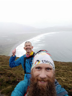
I was delighted that my good friend, Sean Nickell joined me this weekend. I needed his experience over mountains and rough terrain for these two tough stages. It was a long drive down to Achill Island on Friday night but at least we had the luxury of a beautiful guesthouse and delicious breakfasts supplied by Anne, our wonderful host in Joyce’s Marian Villa at Keel Strand.
After a very hearty breakfast, Sean and I drove the short distance from Keel to Doogort (6km) to begin today’s stage. There is a beautiful beach here (Pollawaddy Strand) at the foot of the towering Slievemore. In 1831 an evangelist Edward Nangle arrived in Doogart and build slated houses, a printing press, a hospital, a post office and a corn mill. He also instigated the reclaiming of fields from the slopes of Slievemore. Sadly, he faced opposition, especially from Archbishop MacHale from Tuam who felt that Nangle was stealing the Catholic souls for his protestant mission. It does look as if the village has declined from those early glory years. Even the Strand Hotel, which has the perfect setting on the beach, looks as if it has seen better days.
 |
| Starting my watch at Doogart |
Still the spectacular natural beauty of Doogart beach and
Slievemore mountain (672 metres high) remains. Unfortunately, today the top
half of the mountain is covered in mist and cloud. Sean had suggested earlier
about going all the way to the summit, but we quickly realised that this would
not be possible this morning. We started our climb near the hotel, following
the coastal lane which ends abruptly at the pier. From then on, it was
following sheep tracks as we circled Slievemore. As we came around the west
side of the mountain at Ooghnadirka there was a long sea inlet that meant we
had to come inland quite a bit and climb up some hills and into the fog. However,
once we got around the inlet and made our way downhill again we could clearly see
a row of abandoned houses which is Achill’s Deserted Village
Deserted Village
The old village stretches along a trail for about 1.5km. Maureen, Brian and I had a closer look when we were here a couple of weeks ago. We saw traces of about 70 houses but originally there were 137 small cottages. The tiny houses were probably only occupied in the summer where cattle would be grazed on the mountainside.
 |
| Achill's Deserted Village |
 |
| Deserted Village |
 |
| Keeping the sea on our right - heading towards Annagh Strand |
 |
| Lough Nakeeroge and Annagh Strand |
 |
| Lovely long lush grass but not easy to run on |
 |
| Annagh Beach - our first break of the day |
We see signs of a smaller deserted booley village here. Only the remains of one house is left. Way in the distance, we see a couple of men herding sheep. They must have climbed over hills and through fields as there are absolutely no roads or lanes in this area. They might be modern day ‘booley’ farmers.

 |
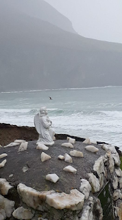
| At Saddle Head - looking across at Cliffs of Croughane |
 |
| At sunny Saddle Head looking at foggy cliffs of Croughane |
 |
| Enjoying the sunshine at Saddle Head (NW corner of Achill) |
Although Saddle Head is now basked in sunshine, it’s another story as we look south. We can see the towering cliffs of Croaghane, but the tops are covered in thick fog and our plan to stick to the coast today looks, not only tricky, but treacherous. We try to access the cliffs a little further inland, and we climb higher and higher as the fog gets thicker and thicker. Eventually we make it all the way up to a small lake, Bunnafreva Lough West. (318 metres high). The Irish naturalist Robert Lloyd Praeger said this lake was, “so lonely and sterile and primeval that one might expect to see the piast or other Irish water-monster rising from the inky depths”. It is indeed an eerie place here by the lough, surrounded by mountainous cliffs. Today, shrouded in thick fog, it looks even more ‘lonely and sterile’. As we ponder here at Lough Bunnafreva West, the temperature is dropping, and my hands are getting cold. We decide that it would be foolish to climb up any further and so we make a sensible decision to turn around and descend about 250 metres.
 |
| Trying to go around the fog |

To avoid (and get around) the fog, we ended up going all the way back to Lough Nakeeroge and climbing over the hills. We were even able to follow some yellow arrows on rocks here which guided us over the hills to the southern part of the island. (This is probably the route, the farmers we saw earlier, take to reach their sheep). In hindsight it might have been safe enough to have stayed up higher on a 200-metre ridge that would have taken us all the way to Lough Acorrymore. If we had gone this way, we could have then followed the trail (Keel Way) down to the main road. However, today we had a rougher journey, crossing a long boggy field that brought us to a row of holiday homes called Corrymore Village about 3km east of Keem strand. With so few people around, I couldn’t help thinking that this was like a modern version of a deserted village.
 |
| Keem Strand at last |
 |
| Washing feet on Keem beach |
Dooagh
Dooagh became famous in 2017 because the beach reappeared after being ‘missing’ for thirty years. We did try to run along the shore, but it looks like the beach has disappeared again! The artist Paul Henry lived nearby and fell in love with Achill. He only came for a holiday but dramatically he ended up throwing his return ticket into the sea here in Dooagh. Also in this area, the writer, Graham Greene, not only fell in love with Achill, but also fell in love with Catherine Walston. They were often spotted in the Clew Bay Hotel (now Gieltys). The book and film ‘The End of the Affair’ covers their passionate relationship.
Daylight is fading now as Sean and I eventually reach our destination at Joyces Guesthouse in Keel. A special thanks to Kathleen Joyce (sister of our host Anne) who drove me back to Doogart to collect my car. After a quick shower Sean and I enjoyed a couple of drinks and a well-earned meal in the Amethyst Pub around the corner. As my mother-in-law would say, we ‘slept without rocking’ tonight.
Stage 61- Revisited: Achill: Croaghaun Cliffs: Sat,10 June 2023: 16.6km or 10.3miles
“Achill, wind-swept and bare with great gaunt brown mountains rising here and there, and a wild coast hammered by the Atlantic waves on all sides.” Robert Lloyd Praeger

Back in September 2021 when Sean Nickell and I were in Achill we tried unsuccessfully to climb these cliffs, the highest in all of Ireland. At that time, we approached the cliffs from the north side. The cliffs were steep, and the fog was coming down, so we moved a little inland and slowly climbed up as far as Bunnafreva Lough West, 318 metres or 1,043 feet high. Reaching this lake, we were still only about halfway to the top. The fog was getting thicker and the air colder. This corrie lake was also called Loch Réithí Dubha, referencing its often deep-blue-black colour. The historian, Praeger was correct in calling that this a ‘lonely and sterile place’. For Sean and me, the low cloud added to the scary atmosphere. The small lake surrounded by steep cliffs gave Sean and I the creeps! We didn’t delay and it would have been treacherous to climb any higher.
 |
| Croaghaun Cliffs |
There was an even earlier account of this mountain lough by Edward Newman in 1838. ‘’Near the margin of the cliff a beautiful little fresh-water lake, surrounded by an amphitheatre of hills. I should think its surface was 1,000 feet above the sea, and its distance from the edge of the cliff scarcely 300. I doubt whether any Englishman but myself has ever seen this lone and beautiful sheet of water; its singularly round form, the depth of the basin in which it reposes, the precipitous sides of the basin, its height above the sea – all these are characters of no ordinary interest”.
Still, I had to go back! Not only to climb those famous cliffs but to try to reach that lake again, Bunnafreva Lough West (or Loch Reithi Dubha). So, twenty-one months later I returned to Achill with my son, Matthew.
 |
| The Greenway that goes all the way from Achill to Westport |
It’s a dull Saturday morning and I’m not feeling optimist about being able to reach the top of the Croaghaun Cliffs. The weather in the west of Ireland has been exceptionally warm and sunny for the last few weeks but unfortunately the forecast was not great for this weekend.
After parkrun and breakfast, we drive along the main road, the R319 all the way to Keem. The mist and fog do seem to be clearing as Matthew and I start our hike from the beach at Keem. (I’m not really calling it a run or walk). Parking our car by the strand we plan to do an anti-clockwise loop. We walk back up the main road for about 2km and then take a left turn and ascend another 1.5km until we reach Lough Acorrymore. That’s 187 metres high already and thankfully there’s not much mist or fog at this level.
 |
| Crossing the dam at Lough Acorrymore |
We cross over the dam and stay right to avoid a steep ascent. It’s then a steady climb up the hill. The weather is brightening up and we can admire the views all over the island. It’s only when we get up as far as the 500-metre point that the fog slowly engulfs us. Now we must try to locate ‘Bunnafreva Lough West’ that Sean and I had reached in 2021. It was not easy to find it. Lucky for me I had my son Matthew with me. He was able to pick up a satellite connection and eventually, despite the heavy fog, we found the ‘beautiful little fresh-water lake’, described by the Englishman, Newman in 1838. We were able to look down from our height of 510 metres to the lake below which was 318 metres. The lough was still barely visible in the fog but that round shape makes it easily recognisable.
 |
| Looking down onto Lough Bunnafreva West |
After leaving Lough Bunnafreva West, we walked slowly through the fog towards the western cliff top. The coast then became our compass as we headed south. Normally, I would say, ‘stick to the coast’ but in this case, it’s safer not to get too close. Still, it’s not as scary as I thought it would be but I’m so glad to have my son Matthew with me. After a while we had to climb even higher as we manoeuvred our way through rocks until we finally reached the highest point on the island at 688 metres (2,257 feet in old money).
 |
| At the highest point on cliff, 688 metres |
 |
| When you know you're at the top |
 |
| We had to clamber through rocks, big and small |
 |
| Wee Matthew with giant cliffs behind him |
Matthew and I still a long way to go and more cliffs to climb (and descend). I had forgotten how mountainous Achill is. We cross a narrow river at Ooghnagertleen and head west towards Achill Head in the SW corner of the island. I was determined to reach the tip of Achill Head (it looked easy on the map). However, to be here and witness the narrow, broken ridgeways that lead to the head was another story. It looked treacherous to walk across the ridge. We did attempt one section but quickly realised that it would be foolish to go any further. If anyone is reading this, DON’T even think about trying to reach the extreme corner of Achill Head. It’s completely dangerous.
 |
| The route (to Achill Head) not taken! |
 |
| Looking towards Achill Head |
Even though we are in a remote part of Achill there are lots of sheep around. Up to now I’ve had a very good relationship with sheep on my coastal runs. Cows I don’t like, but sheep usually jog out of the way. However, near to Achill Head, Matthew and I met an aggressive ram! The ram stared at us and prepared a marching stance, like a bull. He had the horns too. Unfortunately for Mathew and I we were very near the edge of the cliff when the ram confronted us. We stopped walking and moved back a little. I also took off my rucksack, preparing to use it as a weapon if necessary. After a while, the ram calmed down, slowly moved out of our way and, with relief, we were able to continue. Still, I now have a new respect for sheep. Matthew commented that because we were so far from civilization the ram was not used to seeing any people.
 |
| Sheep not impressed with trespassers |
It was getting cloudy now and still more cliffs to climb - and descend - depending on what way the sea inlets came in. We can see Keem Strand in the distance and the remains of Captain Boycott’s house on the hill above.
Captain Boycott and Michael Davitt
I knew the
story about the man with the notorious name, Boycott and he lived here with his wife. However,
I didn’t realise that Captain Boycott was a land agent rather than a landlord. In
those days, the agents had to do the dirty work in collecting rents. Some land agents
were stricter than others in making sure monies were collected and Boycott fell
into this category. When he lived in Achill he was a successful farmer but felt
a little isolated, as there was then no bridge on the island. (it wasn’t built
until 1886). An opportunity for Boycott came in 1872, when John Crichton, 3rd
earl of Erne, who owned 2,184 acres in Mayo, offered him the agency of lands
near the Neale, Co. Mayo, and a lease on a farm of 629 acres with a good house,
stables, a ruined castle, two islands, a boathouse and sporting rights. Sounded
like a job offer he couldn’t refuse.
Boycott relished the task and became a very strict land agent. Despite poor harvests he insisted tenants paid their full rents. As it happened the Land League protests were just starting at that time, led by Michael Davitt. These were peaceful demonstrations which eventually led to a campaign where local shops refused to serve Captain Boycott and his estate. Soon the story became nationwide, and his name came into the English language. Boycott never recovered from the humiliation. Ironically, when the bridge into Achill was opened in 1887 it was called ‘The Michael Davitt’ bridge and Davitt himself opened it. To me, Michael Davitt was a true Irish hero who fought peacefully, especially for small farmers in the west of Ireland. My own grandfather continued Davitt’s fight for land rights and in 1916 was involved in a ‘Cattle Driving’ campaign.
 |
| At Moyteoge Head |
 |
| Coming back to Keem Strand |
Matthew and I still had to reach Moyteoge Head. There are light drops of rain, but we don’t mind as we know our finish line is close. However, the wet grass has made our final descent down to Keem a little slippery. It has been a hard day, tougher than I thought. When we finally reach Keem Strand we dip our feet in the sea.
 |
| Resting feet in Keem Beach |
After seven years running around the coast, I would have to say, Achill has probably been the toughest part so far. After today’s adventure, Matthew and I drove to Keel and stopped off for a lovely meal at ‘The Amethyst Bar’. Afterwards we even stocked up on Achill’s secret spring water. No drink ever tasted as good!
 |
| Filling up with special Achill water |
Co. Mayo: Achill: Keel to Achill Sound
Sunday 26 Sept 2021: 31.05km or 19.3miles
A soft day, thank God. A wind from the south with a honeyed mouth; a scent of drenching leaves (Winfred M Letts)

 |
| Running through golf course in rainy Keel |
 |
| On Minaun Cliffs with Keel beach behind |
At the southern end of the beach there are a few house and this is called Dookinelly which was once the biggest village in Achill but due to famine and emigration it has greatly diminished. There is a Cillin here, a burial place for the unbaptised (paisti marbha). I've passsed quite a few of these cillins on my coastal runs.
 |
| Cillin at Dookinelly on Keel Strand |
 |
| A soft day so far |

 |
| In memory of crew on Lios Garra |

 |
| Spectacular cliffs and perfect grass for running on |
Along here we pass two small memorials. One is marked just ‘Raymond’, but I think it’s for Raymond McKenna who went missing in this area exactly ten years ago. I notice that Raymond’s birthday, 31 March, is the same day as my son, Brian. That’s a nice connection as this Clifton Run is dedicated to Brian. The other memorial we pass is in memory of crew members of the Lios Garra fishing boat which sunk near here in 1979.
 |
| Time for a break at Dooega .... and its brightening up |
Shortly we arrive in the seaside village of Dooega (Dumha Eige). We pass a monument dedicated to Thomas Patten who was the first Irishman to lose his life in the Spanish Civil War. He was one of many young men who fought with the Fifteen Brigade against the fascist Franco regime. Christy Moore referred to him in his song, 'Viva La Quince Brigade’.

We’re now able to follow the quiet road that loops around the southern part of Achill. After two days of mountain and hill climbing I’m struggling but at least it’s relatively flat from now on, well except for one last steep hill at Port na hAille (beautiful bay). With the sun now making an appearance it is indeed a beautiful view. From here we can see all of Achill with the hill tops clearly visible. Clare Island is sitting majestically in the middle of the bay.
 |
| At Port na hAille with Clare Island behind |
There’s no fog at all now and Sean is cursing the fact that, today (unlike yesterday) we could have got to the top of Slievemore and crossed over the Croaghane Cliffs. Also, if it wasn’t for the high tide we would have got to see another reappearing beach here at Ashleam Bay, similar to the one in Dooagh which we passed yesterday.

 |
| Pub built especially for film |
 |
| Our rucksacks carry so little compared to these ladies |
Shortly we arrive at the most southerly point of Achill Island at Cloughmore (An Chloic Mhor). Just off the southern point is Achillbeg which is now uninhabited since the 1960's. There had been one hundred inhabitants on this island in 1900 but even in the 1950’s all eight pupils in the school were siblings.
 |
| What a beautiful day here at Cloughmore (SE Corner of Achill Island) |
 |
| Looking across to Achillbeg |
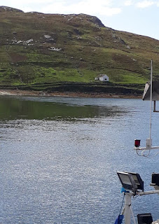
Heading north we can now see the Achill Bridge in the distance. We pass Kildavnet Tower which is another one of Grainne O’Malley’s castles. Behind the tower is (the fog free) Cnoc an Chorrain (Coraun Hill).
 |
| Kildavnet Tower |