STAGES 74-75: Ballyconneely to Glynsk
 |
| At Roundstone (Nimmo's) Pier |
Stage 74
Co. Galway: Ballyconneely to Roundstone Thursday 29 September 2022
22.73km or 14.12miles
"Sometimes the most scenic roads in life are the detours you didn’t mean to take." (Sign outside Coffee Cottage in Roundstone)

With Covid not so prevalent now, and people travelling more, it is getting difficult to find a place to stay. Luckily for me I have that Galway connection and I can use the city location as a base for these Connemara runs. We did find a lovely B&B (Island View) in Roundstone on the Thursday night with the perfect host in Maurice. Also, two weeks ago, I ‘pre-visited’ this area and completed Inis Nee Island and Rosroe Peninsula (in perfect weather) which made it easier for me over these days.
 |
| At the end of the boreen at Murvey, near Roundstone |
 |
| Croaghnakeela or Deer Island |
Just as the wee road came to an end I met a father and son who were building a wall, making the most of the fine weather. The man pointed out for me the island of Croaghnakeela although he called it Deer Island as it was once stocked with deer. I left the working men, and I was able to rough it for about half a mile over a rocky hill before reaching another trail. As I climbed over a small summit I could see this beautiful beach in front of me. It was Dogs Bay beach (Tra Chuan na Mhada) in all its glory. As I was already close to the coast I contemplated staying by the shore and trampling across a few fields to get to the strand. However, I thought it wiser to follow the proper trail back up to the main road. It was a good decision because when I reached the main road I had the perfect downhill run and my fastest kilometre (4.51) of the two days.
 |
| Dogs Bay or Tra Mhantan |
In Irish, Dogs Bay is called Tra Mhantan, and I think Mantan was an apostle of Saint Patrick. When I reached the beautiful beach I kept running, even meeting along the way a French ultra-runner, Michel Le Merle and his wife Janet. I continue around the whole peninsula as far as Gorteen Point and join Gorteen Beach on the other side. These two beaches form, what’s called a tombola, which juts out into the Atlantic.
 |
| With Michel Le Merle (Ultra Runner) |
 |
| Gorteen Bay |
 |
| Gorteen Bay: Maureen & Brian are dots in the distance |
 |
| Brian & Maureen on Gorteen Beach with Inishlacken Island behind |
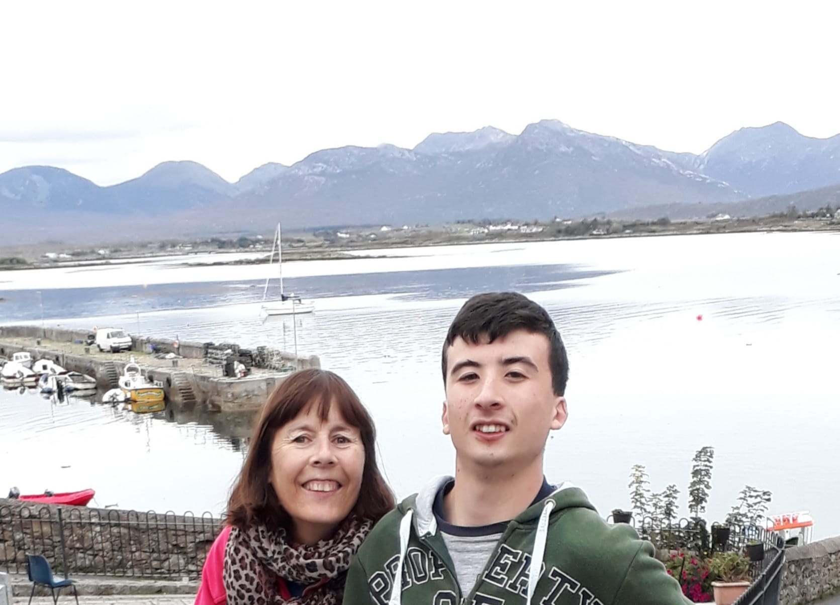 |
| Roundstone with Twelve Pins behind |
Cloch Na Ron, Bruce Ismay and Alexander Nimmo
The name Roundstone is a bad English translation and I much prefer the prettier
sounding Irish name, “Cloch Na Ron” (Rock of the Seals). It’s said that Bruce Ismay, chairman of
the White Star Line (owners of Titanic) came here in 1912 for some peace. I figure
he wasn’t very popular after surviving the voyage by getting onto one
of the lifeboats. Another famous character, Alexander Nimmo had no formal education in
engineering but designed so many piers and harbours around the country. In
Galway City there is even a pier in the Claddagh called ‘Nimmo’s Pier’. He was
Scottish and only came to Ireland when he was in his twenties. He had a special
devotion to Roundstone and not only, constructed an impressive new harbour but also
went on to develop most of the village itself. It is believed that Alexander Nimmo is
buried in the village but it’s not clear where exactly his grave is.
Stage 75
Co. Galway: Roundstone to Glynsk
Friday 30 September 2022
28.12km or 17.47miles
"I can only think in the dark and in Connemara I have found the last pool of darkness in Europe." (From Tim Robinson’s book, The Last Pool of Darkness)
 |
 |
| Inspiration sign in Roundstone |
 |
| Even the sea looks rough today |
It’s 8.03am, dark and wet as I start today’s run. After about 3km I passed the bridge to the island of Inishnee. In hindsight it was such a good decision to complete this island two weeks ago when the weather was much better (see later). Despite the miserable rain today I was also lucky to have a strong west wind behind me.
 |
| Another one of those signs in Roundstone - I needed that inspiration today. |
I followed the main road and after another 2km I took a right turn and another right, heading south towards the old village of Aillenacally. The village contains fourteen houses now deserted and in disrepair. Nobody has lived here since the 1950’s. An Irish American has bought some land here and maintains that Aillenacally is the ‘oldest village in Ireland’. Years ago, schoolchildren used to walk from the village in a north direction through the bog to the school at Toombeola. I had read that there were steppingstones to guide you across the path. It was called ‘The Scholars Road’. According to local writer Michael Halliday, the walk or trail starts about 400 metres up from the shore but it's still difficult to find. Luckily for me, I met a local farmer at the exact spot where the steppingstones began. He didn’t seem to know it was called ‘The Scholars Road’ but he knew about the stones and literally pointed me in the right direction. At this stage it was pouring rain, but I was able to make my way across the bog, trying to find the odd stone to step on. Sometimes it was so boggy and wet that I had to leave the 'path' for a dryer section. I worried that I might lose the path as it wasn't that obvious to see. All the time I was thinking of those poor children on cold and wet mornings taking this same journey. It stopped me feeling sorry for myself.
About two thirds of the way across I
did lose the trail. The stones seemed to disappear, so I had to plod along
through the fields. Eventually I could see houses nearby and I was able to
climb over a farmgate to reach the main road at Toombeola. The literal
translation is 'Tomb of Beola' and Beola was an ancient chief in Connemara).
 |
| This is along Lehenagh peninsula |
Shortly I cross over a bridge and then take a right turn
signposted to Cashel. This section of the road is quite narrow and winds its
way around the shore. I’m reminded of how Tim Robinson described it ‘the
road has to swerve and twist like a cyclist chased by a snappy sheepdog’. Robinson
was an English writer who sadly died recently in 2020 due to the coronavirus.
He was a Yorkshire writer who like the Normans ‘became more Irish than
the Irish themselves’. He had lived here since 1972 and became a
well-known historian in Connemara. I think I would have got on well with him. He
began to explore and record his surroundings closely, walking on foot and even,
designing his own maps. I wish Tim Robinson was around to guide me along
this part of the shore. I love the way he describes his own coastal adventure
‘’While walking the land, I am the pen on the paper; while drawing this map, my pen is myself walking the land’’
I passed by the entrance to Rosroe Peninsula and again count myself
lucky that I’ve already completed that section of the coast (see later) in much
better weather.
Cashel House Hotel
I decided to have a break here at the hotel and hopefully get some water to drink. All that rain and I'm still thirsty! The sign outside the hotel said ‘Residents Only’ but I ventured inside where I noticed breakfast was being served. A young lady gave me a big jug of water and I sat in the lobby knocking back a few glasses.
Back in 1969 Charles de Gaulle, just a month after his resignation as president of France, came to Ireland, and spent two weeks here at the hotel. Cashel House only received a week’s notice that the big man was coming. There was great panic as management worried they did not have a bed big enough for the 6 foot 5 inches (1.96 metres) Frenchman. I like the comment in the Irish Times at the time that has a connection to my adopted town in Northern Ireland. ‘The presence of General de Gaulle here is almost as bizarre, in its first impact, as would be the announcement that Chairman Mao had arrived in Bangor, Co Down, to enjoy the amenities of Pickie Pool.'
At the time De Gaulle tried to explain why he came here. 'It was a
sort of instinct that led me towards Ireland, perhaps because of the Irish
blood that courses in my veins.' There was
some truth in De Gaulle’s comment about his Irish blood. His
grandmother was descended from the McCartans of Co Down and she even wrote a book
about Daniel O’Connell. 


Stage 75- PRE-visit: Saturday 17 September 2022 Rosroe Peninsula, Cashel. 16.01 km or 9.95 miles

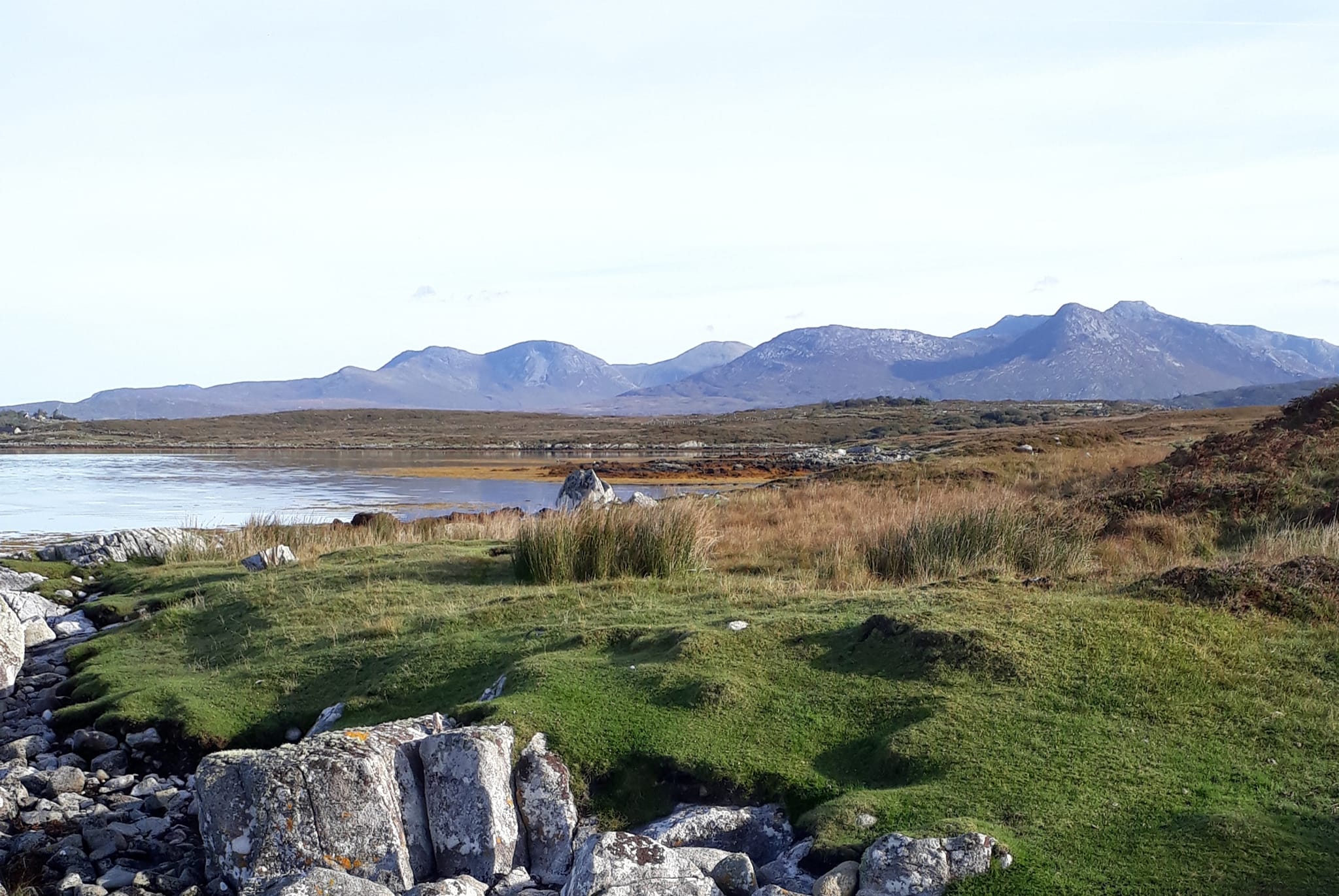
 |
| Rosroe Peninsula with na Beanna Beola behind |
The early sunshine over the mountains lit up the whole of Connemara. I parked my car in a lay-by just opposite, what was once, Willie Bolgers Pub and headed back along the road. As usual I was running anti-clockwise, with the sea on my right. Rosroe probably translates as the ‘the red peninsula’ called after the boggy terrain. I couldn’t find anything on-line at all about this area so maybe I am one of the few people to circumnavigate the Rosroe peninsula! Although I know for a fact that the famous local historian, Tim Robinson did walk every section of this coastline. It was the perfect morning for a run along, what started as a country lane, even if the trail became rougher and rockier. The trail eventually disappeared after only about 2k. I had to slow down as I trampled through the bog and the long grass. I thought it was best to get closer to the coast and it did seem a bit easier even if there was no proper beach to run along.
 |
| Looking across Cloonile Bay to Inis Nee Island |
No sign of anyone along here. It's so quiet and peaceful with perfect calm water as I run along the southern shore of Cloonisle Bay (or Blackhaven Bay). In the distance I spot a lone fishing boat across the sea heading towards the pier at Inis Nee Island.
 |
| SW corner looking toward Oghly Island |
 |
| I fine a trail again! |
Climbing over a few barbed-wire fences, I eventually reached the SW corner of the peninsula. I must have scared the local wildlife as a seagull or tern came screeching along the shore and was still quite vocal as it flew away. Across the bay I could see Oghly Island. (Oilean an Chlai). Later when I was running around Inis Nee, I spotted the island from another angle. It looks quite pretty, has a nice beach and apparently a tidal swimming pool. Definitely not an ugly island!
 |
| Canower Harbour |
 |
| Stand off with cow near Canower Pier |
Stage 75- PRE-visit: 11.38am on Saturday 17 September 2022 Inis Nee Island 12.03km or 7.48miles

 |
| Looking across to Roundstone Village |
 |
Roundstone itself is notoriously busy over the summer but, even on a beautiful Saturday like today, it’s very quiet here in Inis Nee on the other side of village. The island of Inis Ni is said to be shaped like the figure eight but to me it really looks like there are three sections or three round-shaped islands. Near where I park, a map highlights a ‘the loop walk’. Looking at that map and my own OS map, I start my run and take an immediate left, passing a few houses. When this road comes to an end, there is no sign of a trail, that was marked on the maps. I rough it through fields expecting to find some path but can’t see any. A few days after I did this section I read an article 'Walking in Roundstone' by Michael Halliday saying 'Do not attempt to walk on some maps by taking the first left after the bridge - it becomes too difficult and unpleasant'. Pity I didn't read that first!
Eventually I do join up with a lane that brings me down to a pier and I'm able to cross over to the middle section of the island. I talk a left turn which leads me onto the most beautiful grassy coastal path. This trail is perfect for running on and to cap it all, there are magnificent views of the twelve pins (na Beanna Beola). These mountains are spectacular today and watching over me wherever I am.
 |
| The Twelve Pins (Beanna Beola) |
 |
| The perfect coastal path! |
 |
| Maladdin & Gerry with Twelve Pins behind |
I stop to chat to a few people who are walking this route. I’m now at the closest point to Oghly Island sitting peacefully in Bertraghboy Bay. I keep running and join the bottom (most southerly) section of Inis Nee island. I follow the road to the very end and do my own loop through the bog. I then double back the whole way and follow the straight road north all the way back to the bridge. Bye bye, Inis Nee.