Stage 47
Co. Mayo: Ballina to Kilcummin Strand
Saturday 22 August 2020
40 km or 25 miles
"The French are in Killala, the
hour is now at hand, for which we've sighed and waited and prayed for
fervently" (22 August 1798)
It’s good to be back! I did wonder when exactly my
Coastal Run would continue. Remember, I had just got Stage 46 completed on 15
March before everything shutdown because of the Coronavirus. Now I’ve reached Co. Mayo, the county with a
notorious long coastline. I think it will be just as long as the coast of
Donegal (935km) which took 26 stages to complete! Also, I’ve been suffering from a
thigh strain for the last few months so it will be tough running today. 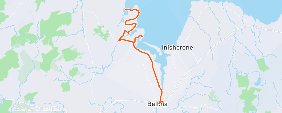
At least ‘Storm Ellen’ which has been battling our shores has eased off. It
was just Maureen and I making the long
trip to Ballina, staying at the lovely Twin Trees hotel in the town. I waited a
long time to continue this coastal run and I deliberately picked today (22
August) as I knew it was the exact anniversary of General Humbert’s landing at Kilcummin
pier (just north of Killala) in 1798. I did consider dressing exactly as
Humbert, wearing ‘‘a long green
hunting frock and a huge conical fur cap’’ but I don’t think I would
have been able to run very far in that gear! As it happened I forgot to pack my
shorts and I only noticed this at 9.00pm the night before! I remembered I had a
North Down AC tracksuit bottoms in the car and after borrowing a scissors from
reception I was able to improvise, although Maureen did comment that I cut too
much off one leg!
 |
Me in my improvised shorts - one leg longer than other!
|
I
had a quick breakfast in our bedroom in Ballina and began my run at exactly
8.00am. Maureen promised to meet me later at the finish line on Rathlachan
strand at 1.30pm (low tide was 2.00pm). I left the Twin Trees hotel and crossed
the Moy River - best salmon in Ireland and favourite fishing haunt of Jackie
Charlton! I then headed north towards Belleek Forest just outside the town. This
was a lovely path through the woods and, although it was now raining
relentlessly, I was somewhat protected as I ran through the trees. I kept to
this path to the very end of the forest and then took a right turn onto
Knockatinnole road. This was a quiet country road and I think I only met two or
three cars for the next 8km as I headed towards Killala. The road is also
nicknamed ‘Frenchman’s Road’
as General Humbert and his men would have marched this way. Thinking about this, I
really felt a sense of history as I ran along here. The rain is still teaming
down though and by the time I reach Killala I’m soaked to the skin. I had read
that when Humbert’s men got to Killala, a French soldier climbed to the roof of
the palace and replaced the British flag with a sign that said “Erin go Bragh’’.
 |
Traffic jam on the road to Ross Strand
|
I
don’t delay in Killala and decide to keep running north and after about 1km I
take a right turn signposted ‘Ross Strand 3km’. With all the rain, this country
road is flooding now but I try to avoid the puddles and run all the way down to
the beach itself. I get talking to some brave sea water swimmers (called the ‘Grim
Reapers’) who have just been in for a swim. As we’re chatting, the rain stops at
last and the sun is even trying to make an appearance. It’s just 10.00am.
 |
With 'Grimm Reapers' swimmers at Ross Strand
|
 |
View of Bartragh Island from Ross Beach
|
I leave Ross Beach, run back up the road again and continue in the direction of Ballycastle. After about 3km I cross the
river Cloonaghmore at Palmerstown (or Parsonstown) – ‘’a majestic stone
bridge of eleven arches’’ as Valerian Gribayedoff called it in 1890.
 |
Palmerstown bridge west of Killala
|
After
crossing the majestic bridge I take the road to the right, heading north along ‘Humbert’s Way’. 3km later I come to a small crossroads and I take a right, signposted ‘Rathfran Graveyard’. I’m able to
loop around the road by the ancient graveyard and then continue along
the coastal boreen until I get as far as a T junction at Castlemagee.
 |
Rathfran Graveyard
|
At this
stage I’ve run about 20 miles, my legs feel heavy and I’m walking
up the hills. The good news is that I'm drying out nicely. I have to come inland (left and right turn again) but I
eventually join up with Humbert’s trail again which leads me all the way down
to Kilcummn Pier. This is the exact spot where Humbert and his men arrived in
1798.
 |
Arriving at Kilcummin Pier where Humbert landed
|
General
Humbert
Humbert and his men had left La Rochelle in France
on 4th August to great crowds that ‘shouted themselves hoarse to the army of Ireland’. There were
only 1,130 troops in his ‘army’ on the three ships. Compare that to the 14,450
French soldiers (accompanied by Wolf Tone) that tried to land in Bantry, Co.
Cork two years earlier but couldn’t due to severe gales. Among the 1,130
soldiers and officers in Humbert’s army was Wolf Tone’s brother, Matthew.
Another Irishman with Humbert was his interpreter Henry O’Keon who was born in
Kilcummin and this is probably the main reason why they landed in this part of
Mayo. Humbert also brought 5,500 arms for the ‘Irish peasantry’ who he hoped would join him.
‘‘We have come to your country, not as
conquerors, but as deliverers’’

 |
And me, standing on 'Humbert's Stone'
|
Even before Humbert’s men arrived in Ballina there were rumours already
spreading in the town about the oncoming French army. Letters had been
distributed in Ballina looking for Irish volunteers to join Humbert. A young
man, Patrick Walsh had been caught with one of these letters (the day before
Humbert’s army arrived) and without any kind of trial he was hanged in the
Crane at the Ballina market. Walsh’s body was still hanging when Sarrazin
(Humbert’s second in command) arrived with his men. I am indebted to Valerian
Gribayedoff a 19th century writer who in 1890 described the
exact scene (illustrating it too) when Sarrazin and Humbert’s men arrived in
Ballina and spotted Walsh’s hanging body at the crane.
“Sarrazin stepped up to the crane, threw
his arms around the inanimate form and imprinted a kiss on the livid brow. He
then ordered Walsh’s body to be cut down, carried to the nearest chapel and
attired in a French military suit. His body was then placed in a handsome
coffin and all this to the tune of ‘Marseillaise’ and ‘Ca Ira’.
 |
Sarrazin (Humbert's 2nd in command) at Walsh's hanging body
|
This ritual of respecting Michael Walsh’s death and treating him like a
martyr impressed the local Irish more than anything else and many joined the
French men after this. Humbert's small, but growing army, went on to trick and deceive General Lake, the British
army commander, by taking the road west of Loch Conn. They marched south and won a famous
battle in Castlebar, despite being outnumbered by three to one. In defeat General Lake
and his men ended up galloping away and so the battle became known as ‘the races of Castlebar’. Humbert
then declared ‘A republic of Connacht’ but of course like all Irish uprisings,
it eventually ended in tears. For General Humbert and his men, defeat came
a few weeks later in Co. Longford.
Back in the year 2020 the weather was brightening up nicely for me. I
left Kilcummin Pier and headed north once again. As I walked up a steep trail
(which was my final hill of the day) a lady stopped me and said ‘‘did you run all the way from Killala’’.
I told her I was going to run along Cummin Strand and cross the beach and
stream to reach the other side at Rathlachan. She said ‘‘No, you can’t do that’ and then added that, if I am going to attempt
it ‘’to take a line at the church on
the hill and cross at that point’’. She emphasised not to cross the
river too near the sea as the current would be too strong.
I carried on and as I came to the top of the hill a beautiful view
stretched out in front of me. It was Cummin Strand in all its beauty!
 |
Cummin Strand with Rathlackin in the distance
|
I ran
along the cliff top road and shortly was able to get down onto the beach. It
was just 1.00 pm now so I knew I had plenty of time to walk across the long strand (after 24 miles today, I couldn’t run anymore!). I knew it was low tide at
2.00pm too so all was going very well so far! When I finally got to the end of
the long beach I spotted Maureen in her pink top in the distance. However as I
got closer to her I noticed that there was a fairly wide stream/river (maybe 8
metres wide) between us! The sand was also very soft in parts and there was a slight
current on the river. And so for the next few minutes we both looked for a good
crossing point, Maureen on one side of the river and me on the other.
 |
Maureen's photo of me (after 25 miles) on other side of river.
|
We were
like two young lovers trying to communicate across a dangerous border! I
remembered what the lady had said ‘take
a line at the church’ and as it happened we were at that exact point.
I could see the church on the hill behind Maureen on the other side but it
still looked too risky to cross over. Eventually we decided it was going to be
too difficult and so we arranged to meet back on Kilcummin Pier. Maureen was
able to drive back to the pier and I had a nice 2km stroll in the afternoon sun
to meet her there. On the way back I met that same lady again. She said she had heard
that years ago women used to cross over to Rathlachan and used the church on
the hill as a marker or line. Still I was glad I didn’t risk crossing over. Anyway
being reunited with Maureen on Kilcummin Pier (where Humbert originally landed)
was quite a nice romantic ending to today’s adventure.
 |
Reunited at Kilcummin Pier
|
Stage 47 Revisited: Bartragh Island: Saturday 2 September
‘’We are safe here for a while together above the tides reach’’, Tony Hegarty’s poem about Bartragh.
 |
| Showing my run along the north shore of Bartragh Island |
I had seen this island first from Enniscrone beach on the Sligo side (Stage 46) and then later from Ross Strand near Killala (Stage 47). I wasn’t sure if it was possible to run (or walk) across and I didn’t want to take any risks either. However, if it was achievable I needed to get there. My dilemma was solved by Denis Quinn from ‘Wild Atlantic Cultural Tours’ and we booked a trip across with him. It is the Moon’s gravitational pull that causes the tides and, as it was a full moon yesterday, it meant that there was a very low tide in North Mayo.
 |
| Our team of SIX for today (with Aoife, Cassandra & Sean) |
I was also privileged to have my old friend Sean Harte from Galway with us today. His daughter Aoife and her friend Cassandra also joined us. I have known Sean and Cassandra Beggan’s parents for over forty years. I was so pleased that they all came along. Such great company which added to the whole adventure. With Maureen and Brian, we now had a team of six. We arranged to meet our guide, Denis at 1.30pm in Killala and he then drove us a few miles away, to a townland called Ballockpark, which is about 1km south of Moyne Friary. From there we were able to walk across to Bartragh Island. I had told Denis about my Coastal Run, so I left the others for a while and ran ahead to the north side of the island and headed west along the beach.
 |
| Heading up to Bartragh House |
In my absence, the others visited the only house on the island. It was built by Kirkwood family in the 1830’s. In the 1940’s Claud Kirkwood inherited the house. He was a recluse (perfect place he found) and once was referred to in a newspaper article as the loneliest man in the world. On one occasion he placed an advertisement in the local paper saying that the island was closed to visitors ‘Due to the thieving proclivities of certain individuals, Bartragh Island is now closed from this date, except with the written permission of Claude A. Kirkwood'. Just after the Second World War, Claud sold Bartragh to a man named Captain Verner.
Captain Verner’s wife was a sister of the actress Joyce Redman, who was nominated for two academy awards. She entertained some Hollywood friends here. 'Gone with the Wind' actress Vivien Leigh attempted a visit, but the weather did not permit. She could have done with a guide, like Denis. In 1978, the island was offered for sale for £95,000. Seemed like a good deal as in the early 2000’s it was purchased for €1.5million by a consortium led by golfer Nick Faldo. I have seen a video of Faldo talking about a golf course on the island and he seemed very passionate about the whole idea. He loved the natural links courses and had even marked out various holes in the sand dunes. However, for some reason the idea for a golf course never developed. As recently as April 2021 the island was sold again for €1.0 million
 |
| Shipwreck - probably SS Sine |
While Maureen and the others were learning about Bartragh House, I was making my way along the north shore of the island on my own, running as far west as I could. It was not always ‘sand for the feet of the runner’ as I often quote, but most of the time it was a good surface. I passed two shipwrecks quite close to each other on the NW corner of the island. In November 1927 during a storm a Danish ship named the ‘SS Sine’, which was anchored in Killala Bay, was torn free from her moorings and was driven by the wind onto Bartragh Island. The lives of the crew were saved by some men from nearby Killala town. All that is left today of the two wrecks is timber protruding from the sand. I presume one of the boats is the SS Sine. I’m not sure if the other one is the ‘Lady Washington’, which apparently crashed near here in 1867.
 |
| A second shipwreck - it could be 'Lady Washington' |
I run to the most westerly point of the island and around the corner to the other side. I struggle along the south shore of the island as the sand is so soft. Our guide, Denis did advise me to come back the same way because the terrain was quite rough on the south shore and not suitable for running. I decided to climb up onto the sand dunes and try to return on the grass through the centre of the island. This was even harder work as there were no paths through the dunes. I had to come back down onto the beach again.
 |
| Enjoying Bartragh Island |
When I eventually returned to the south-eastern side of the island, my phone rang. It was Maureen. She was with the others on a tiny island nearby called Baunrosbeg and I could already see the group in the distance. I made my way over to join them, just in time to see a whole colony of seals relaxing in the sunshine on a sand bank in the bay. I was then able to avail of our guide Denis, who has such a great knowledge of the flora, fauna and all types of sea creatures. He also knew the exact spots, and underneath which rocks, to find mussels and clams. We nominated Sean (or maybe he nominated himself) to collect some shellfish to take home for personal consumption. Our guide Denis then showed us how to spot cockles in the sand by looking for a tiny air hole. He gave each of us a tablespoon and for the next fifteen minutes we all rummaged in the sand as if nothing else in the world mattered. Even Brian got into the act, spotting some cockles and digging them up with his spoon before adding them to Sean’s collection.
 |
| Aoife has found a cockle in the sand |
 |
| And hands it over to her Dad, Sean |
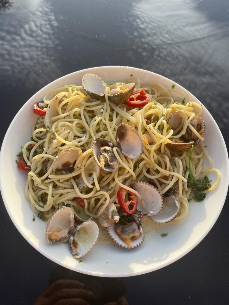
What a lovely way to spend a beautiful summers day. Yes it is September, but today is probably the warmest and sunniest day since June. Still in our bare feet we slowly made our way back to the main shore after a wonderful day’s adventure. Later Sean had the privilege of cooking his seafood cocktail or ‘Bartragh Island bounty’ as he called it.
 |
Sean's delicious looking seafood cocktail
|