Today I had to backtrack a bit to complete this section I missed when I originally did Stage 15 back in March 2018.
 |
| This was back in March 2018 at Magilligan Point |
I think the main reason why Helen, Sean and I missed this part of
Magilligan Strand (east Foyle shore) in March 2018 was because we were just out
of prison! (See original blog for Stage 15). Yes, we had just done the parkrun
inside the prison and we were already about a mile along the country road
heading for Bellarena.
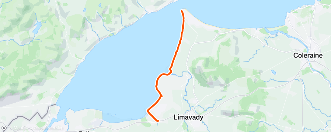
Anyway, back to today – Monday 13 July 2020. It was an early start as I arrive at Magilligan Point at 7.30 am. I’m joined today by my friend and ex neighbour Jeremy McLucas and we’re going to WALK along the coast (it’s not always about running!) It’s a dull July morning and to use a good Galway phrase ‘there’s Rain on the Wind’.
 |
| Magilligan Point with views across to Donegal |
 |
| 7.30am leaving Magilligan Point |
Low tide is at 8.30am – hence the
early start. From here at Magilligan Point we can clearly see Greencastle in
Donegal (only a mile across) and it’s good to hear that the ferry is operating
again.
After a short walk on the road Jeremy and I get down onto a rocky shoreline (even at low tide it’s not as sandy as the Ordnance Survey map suggests!) There are ten or eleven streams to cross along this long stretch of coastline and shortly we come to the first one.
This stream isn’t that deep but at this early stage I don’t really want to get my shoes wet and so I walk barefoot for a while (Jeremy is more prepared with proper waterproof shoes!) As we gradually crossed stream after stream, none of them were as wide as the first one. It probably helped that we tackled this stretch of the coast at low tide.
 |
| Crossing first of many streams |
 |
| Jeremy investigating 'turf' on beach |
We don’t meet anyone at all along this part of the coastline but we do see an old abandoned car on the beach!
 |
| Jeremy checking out Capri or maybe Rover! |
Our original plan was to leave the coast at Scotchtown Road (after crossing all the streams) and then come back onto the main road. However, Jeremy suggested we carry on walking along the coast, through a grassy path as far as the river Roe where the railway bridge crosses over.
 |
| Sea Creature - Jeremy didn't want to get too close! |
Even at low tide the River Roe would be difficult to cross (too deep and too wide). Instead we make our way up onto the railway bridge. Very cautiously, we watch, look and listen to make sure there are absolutely no trains coming and then we quickly cross over the railway bridge. Warning: Please be very careful here! We checked beforehand the times of the train (it was a bank holiday too) and we quickly crossed over the river, making sure not to delay in any way.
We still felt relieved to be on the other side and despite the light rain we stopped to have a deserved break. The good thing about walking is it’s much easier to carry food!
 |
| Nice trail just south of River Roe |
On this side of the river we had the option of varying our walk, sometimes along the narrow wall by the sea (Ballymacran/Ballykelly bank) or later on the nice country trail below. There were lovely views now across to the hills at Bienvenagh (looks a bit like Ben Bulben in Sligo). We passed lovely lush green grass.
 |
| 'Emerald Lawns' - green green grass of home! |
 |
| This path is perfect for cycling |
Jeremy pointed out that this grass is grown by a company called Emerald Lawns. You can buy lawns here and get it delivered to your door the next day! This whole area was once a dense forest (Jeremy informs me) and the building of the Ballykelly bank in the 1840’s meant that thousands of acres were reclaimed from the sea.
 |
| Crossing Burnfoot river |
 |
| Jeremy with Bienvenagh hills behind |
We cross over a small bridge (Burnfoot river) and continue. The sun is even making an appearance now and it’s a very pleasant walk.
There was also an RAF airport nearby which was an important base for anti-submarine aircraft in WW2. A plane crashed into the shallow waters here in 1944 and even today Jeremy and I could still see the remains of aircraft in the sea.
 |
| RAF plane crashed in sea in 1944 |
Luckily, the Canadian pilot, although badly injured, survived the
crash. (but earlier that year, nine Airmen were not so lucky when their plane
crashed in the nearby Bienvenagh hills.)
 |
| Almost home! |
We leave the coast and head inland and shortly we have reached our finish line in the village of Ballykelly. Jeremy’s wife, Tiffany meets us there (and after nice coffee and buns!) she kindly drives us back to Magilligan Point.
 |
| Ferry from Magilligan to Greencastle (Donegal) |
…And so that completes the whole coast of Ulster, even the bits I missed the first time around!
