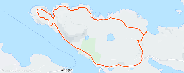
STAGES 70-71: Co. Galway: Tully Cross to Clifden
Stage 70
Co. Galway: Tully Cross to Cleggan
Saturday 21 May 2022: 43.62km or 27.1miles
Our friends go with us as we go down the long path where beauty winds, so why should we fear to join our friends. Oliver St John Gogarty
 |
| Tully Cross via Tully Mountain to Cleggan |
We’ve returned to the lovely village of Tully Cross in Connemara and the plan over this weekend is to reach Clifden, the largest town in this area. It will be another milestone to say that I’ve run from Clifton School in Bangor to Clifden, Co. Galway. Since my last run I also completed the Belfast marathon. This was my third (and last ever marathon!) and I struggled again trying to get under four hours. At least it was another pb (4 hours 5 minutes) but in future I’m going to stick to the start/stop coastal running that I’ve grown to love.
 |
| With view of Co. GALWAY's Crump Island behind |
 |
| Later we went back to Tully Beach |
Out in the bay I see Crump Island (Oilean De Chruinne). I read that St. Patrick’s nephew, Rioch had a small chapel on the island.
Also, there seems to be a dispute as to which county Crump Island belongs to. Those
greedy Mayo people have tried to claim it as their own but as a proud Galwegian
I’ll argue that the island is one of ours.
 |
| Running around Rusheenduff Lough |
Across a few more fields and I reach Renvyle House which is now a hotel. It was originally owned by the Blake family who were not the most popular of landlords. In the 1880’s, as a protest, some tenants drove their cattle onto the Blake’s land. This was common at the time and in 1916 my own grandfather was involved in a similar protest and spent twelve weeks in Galway jail for ‘cattle driving’. In the 1920’s Renvyle House was bought by Oliver St. John Gogarty (writer, surgeon and senator). His love affair with Connemara began when he lost his heart to a Galway girl (just like me!).
 |
| Croagh Patrick far away on left and Mweelrea on right |
I like the way Gogarty describes the location of Renvyle House......
''My house stands on a lake, but it stands also on the sea - waterlilies meet the golden seaweed. It is as if, in the faery land of Connemara at the extreme end of Europe, the incongruous flowed together at last, and the sweet and the bitter blended. Behind me, islands and mountainous mainland share in a final reconciliation, at this, the world's end."
 |
| Job 38.11 ''this far you may come and no further'' |
Speaking of writing, there's a biblical inscription on a paved stone by the shore behind Renvyle House. It’s completely in Latin and the words are from ‘Job 38.11’. Maybe it was best I wasn’t able to translate it at the time, because it says ‘’this far you may come and no further; here is where your proud waves halt’’. This quotation is part of the text in the Bible where Job is wondering how the tides behave. I must admit that the tides continue to fascinate me and as I run along the coast I’m always amazed how the coastal landscape can change twice a day, every day.
 |
| Granuaile's Castle |
After looping around Rusheenduff lake, I join up with
the country road again. I pass Renvyle Castle where the pirate queen Grace
O’Malley (Granuaile) made her home when she married Donal O’Flaherty
in 1546. (one of her three husbands). Nearby is the ‘Church of the Seven
Daughters’ built by an Omey Island chief in thanks for cures that his
daughters received from a local holy well.
 |
| Circling around Tully Mountain |
 |
| Sometimes it was tricky getting around |
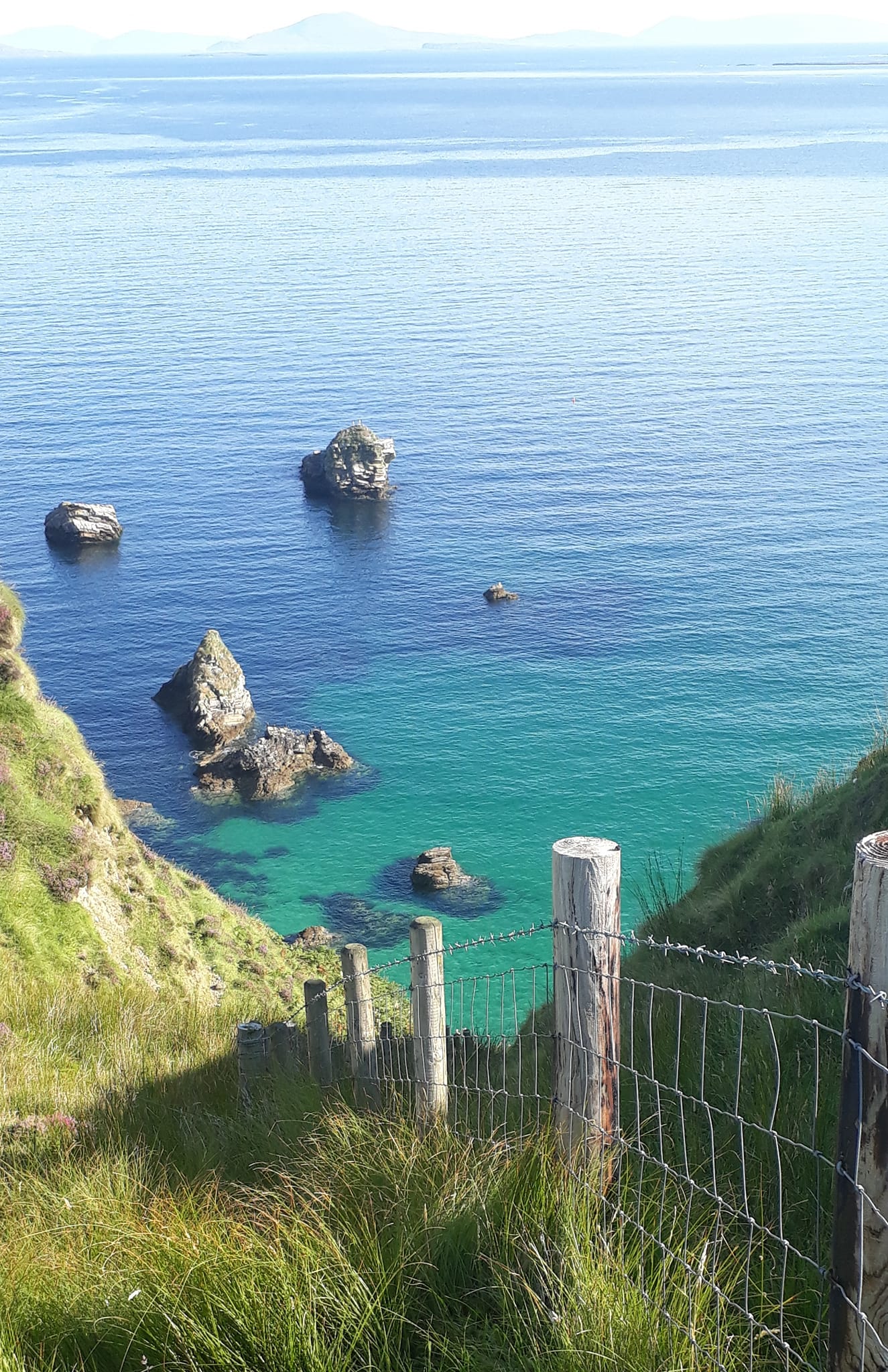
Going around by Tully Mountain was a lonely stretch of the coast. Oscar Wilde referred to the ‘savage beauty of Connemara’ and I know exactly what he means. For miles all I could hear was a squawking bird, maybe it was wondering what this strange two-legged creature was doing in it's territory. I couldn’t make out what type of bird it was or get close. It was probably a raven but it was definitely making itself heard or maybe it was the famous bald eagle (Maol Reidh) that Mweelrea is called after.
I spotted quite a few hares too, some of them the size of small dogs and of course lots of sheep clambering to the edge of Tully Mountain. There were lovely views here with Inishbroon Island stretching out to the north and Braadillaun Island almost connected to the coast.
 |
| Inishbroon Island |
 |
| Braadillaun Island |
Eventually I reached a small farm. Sheep were bleating like crazy here and after clambering over a few more fences I arrived at Letter Beag where the farmers track begins its descent to Letterfrack.
 |
| Guarding farm at Tully Mountain |
 |
| View of Diamond Hill on the way to Letterfrack |
Diamond Hill (442 metres high) now dominates the skyline as I start to circle around Ballynakill Harbour. I stop at Derryinver Pier to admire the view. Just before Letterfrack I pause at Dawros, and wonder should I head west along this peninsula. A car stops at the junction and I get chatting to a man who confirms that Dawros ‘’is a beautiful place and well worth a look’’. I run down to the end at Dawros Beg and it is indeed a pretty spot. At the end of the peninsula, I wonder about running around a wee lake but there’s a gate in front of me with cows sitting behind it.
 |
| Derryinver Pier |
 |
| Cows at Dawros Beg |
Also, what looked like a bridge might have just been a wall. I turned around and headed back up to the main junction again and shortly I arrived in Letterfrack where I have a short break (water, coffee and a croissant) at Kebo Café.
 |
| Wall protecting lake at Dawros Beg |
 |
| View from Dawros heading back to Letterfrack |
Letterfrack (The Speckled Hil)
James and Mary Ellis, a Quaker couple from England, moved to
Letterfrack, during the famine and wanted to help with relief. They built
a schoolhouse, housing for tradesmen, a shop, and a dispensary. Also, in 1911 this
area was also selected by Marconi as the location for his transatlantic
wireless service. However, Letterfrack has a dark history and when I was a young boy growing up in
Galway City, we all knew about the Industrial School here. It’s now common
knowledge that hundreds of young boys suffered terrible abuse at the hands of
the Christian Brothers at St. Joseph’s Industrial School.
After leaving Letterfrack, I join the main road (N59) for about 4k. After passing Moyard I take a right and luckily for me at this point Maureen and Brian pull up beside me. I’m thirsty again and appreciate some more water. Thankfully, there’s no sign of that rain that was predicted in the forecast.
 |
| With Charlie - fellow runner I met |
I continue and stay south of Loch an Gheafra Bhain (Garraunbaun) and then follow the road which takes me all the way to Ross Beach. There are lovely views of sandy Freaghillaun Island from here and way out in the distance I can clearly see Inishbofin Island. (Island of the white cow)
 |
| Shiny stones on Ross Beach |
 |
| With views across to Freaghillaun Island |
With no more roads or tracks along here I struggle through the rough terrain. I had read that there are remnants of an ancient forest in this area. Maybe the branches and brambles are part of it and making my task harder. I climb a hill and spot Ballynew beach below. However, with thorn bushes and more brambles in my way, it was very difficult to reach the strand.
 |
| Ballynew Beach - so close but so far away! |
At this stage all my energy had disappeared, and I knew I wouldn’t reach Cleggan Cliffs today. I’ll have to revisit at a future date to complete the whole peninsula. So just east of Ballynew beach I followed an inland trail that brought me back to the road just north of Ballynakill Lough. I take a right turn and follow the road all the way to Cleggan Beach where I run through the gap between Lough Anillaun and the sea. Anillaun Lake is classed as a lagoon. (I think strictly the definition of a lagoon is one that contains mostly salty water.)
One last kilometre takes me to Cleggan Harbour (another one of Nimmo’s piers). It's been a tough day but I’m so glad to see Maureen and Brian there to greet me. That is enough running for me today. However as it is now low tide we decide to drive to nearby Claddaghduff and walk across to Omey Island. I never miss the opportunity to visit one of my favourite places.
Stage 70- Revisited: Saturday 13 August 2022 Cleggan
Cliffs, Co. Galway : 11.42 km or 7.1 miles
When I originally did Stage 70 on 21st May I wasn’t able to cover all this peninsula. On that day I had already struggled over some rough terrain from Tully Cross, around Tully Mountain and towards Letterfrack. Also, I knew Maureen and Brian were waiting for me at Cleggan Pier. So today I returned on what turned out to be one of hottest days of the year. We stayed last night in Galway City with Maureen’s sister, and I drove out on my own to Connemara for an early morning start. At Cleggan I drove across the slip way (between the sea and the lagoon) and then took a narrow road to the left. I was able to park safely about a half a kilometre up the hill before starting my run.
 |
| 8.15am as I start my circular run near Cleggan Beach |


 |
| Lovely surprise bumping into Michael Stitt, just outside Cleggan |
Stage 71
Co. Galway: Cleggan to Clifden
Sunday 22 May 2022
24.02km or 14.93miles
'A shoulder of rock sticks high up out of the sea, A fisherman’s mark for lobster and blue shark' Richard Murphy describing High Island
 |
| Starting at Selerno B&B and crossing bay at low tide |
 |
| View from Gooreen Island at low tide |
I’m now in the
townland known as Rossadillask which has suffered
a lot in the last 175 years. Stories of the famine in this area are appalling.
I was reading a horrific report about this area and how children were suffering
from dysentery and a mother was struggling to keep her son alive ‘’all
the medicine he wanted was food’’, she said. In October 1927 another
disaster hit the area when a sudden storm caused the death of twenty-six
fishermen in this area. One minute the sea very calm and the next minutes
without any warning gales came whipping from the Atlantic.
This morning I’m so lucky that it’s low tide. Not only can I reach the island of Gooreen but the whole area is brightening up with silver beaches everywhere, one after the other. No wonder the sign on the road said ‘You are now entering Rossadillask, Paradise’. Even though there’s no sunshine, the area has a bright sunny appearance.
 |
| Hard to believe I crossed this bay at Aughrus Beg |
 |
| Near Anchor Beach |
I knew the next part of my adventure
would be tricky. I was attempting to cross the bay north of Lough Atalia (not
to be confused with Lough Atalia in Galway city). Even with the low tide I still needed to
cross two wide streams/rivers. I found a shallow spot to get through the first
wee river on the east side but the second one on the west side was much more
difficult. The river was about twelve metres wide and looked deep in parts. In
one section of the stream, right in the middle, I spotted a small boat. I was then
able to wade through up to my knees and complete the crossing in two stages,
using the boat to manoeuvre my way to the other side.
 |
| I used this boat to help me wade my way across the bay |
 |
| Anchor from wreck of Verity on Anchor Beach |
High Island: St. Fechin founded a monastery here in 634. For a while the island was mined for copper ore but these mines were flooded with sea water. St Gormgal lived on the island in the year 1000 (the first millennium) and it was around this time that Brian Boru, the high King of Ireland, came here for his confession. Shortly after this, King Brian won a famous battle in Clontarf in 1014. Unfortunately Brian Boru and his son both lost their lives at that famous encounter.
After circling the lake, I come to a T junction, and I mistakenly take a left turn (instead of right). However, I’m able to recover 2km later and take the next right and arrive near Sweeneys Pub at Claddaghduff. It’s only 9.00am and probably too early for a drink!
Omey Island: I spot Omey Island ahead in all its glory. There is still a good low tide so I could have made it across but I’m deliberately postponing my run around the island for another time. Omey is a unique place and has been special for me for nearly all my life. More about that the next time when I’ll run all the way out to the island and hopefully circle it.
 |
| Visiting Omey Island |
I’m now on the main road from Claddaghduff to Clifden and running along the north shore of Streamstown Bay. It’s a much quieter than I expected, and I even get a glimpse of the famous Sky Road on the other side of the bay as I get closer to Clifden.
 |
| I'm feeling the pain now and can't even keep up with these guys |
However, once I reach the junction and join the N59 it becomes quite busy. I have a long climb into Clifden over the next 2km or 3km. If I had more time (and energy) I would have taken the Sky Road loop and entered Clifden that way which would have made a lot more sense. I’ll save the Sky Road for the next time. Today I’m happy to arrive at my destination at 10.30am and I enjoy my coffee and cream doughnut. It’s been another tough challenge this weekend but I’m happy to finally reach Clifden, the capital of Connemara.
 |
| Clifden at last! I'm enjoying my coffee and doughnut |
Stage 71: Revisited: Omey Island:
Saturday 16 September: 10.95km or 6.8miles
Now morn has come and with the morn the punctual tide again. Susan Coolidge

Yes, I had to revisit Omey Island as I missed it in May 2022 on my original coastal run. Back then I wasn’t sure if I would have enough time to circle the island before the tide came in. Today I was privileged to have my sister-in-law Aideen Hurley with me and once again Maureen and Brian joined me. We owe a lot to Aideen and her husband Kieran. We’ve stayed so many times at their beautiful house in Oranmore and it has been a great base for me on the Co. Galway section of the coastal run. The sun was shining for most of the day, making up for the miserable weather we had this summer. Low tide is at 2.00pm so we had plenty of time to get here from Galway city. We drive pass Clifden town, head north, take the turn at Claddaghduff church and park the car at the bottom of the hill in front of Omey Strand. It’s such an amazing site to see the huge expanse of open sand that fills up and drains away, twice a day. This island has a magic of its own that never disappoints me.
 |
| Getting ready to go across to Omey Island |
Yes Omey is a unique place and has been special for me for almost 50 years and even before I ever set foot on the island. I discovered this tidal island through reading Walter Macken’s most famous book ‘Rain on the Wind’ where the main character from Galway City spends time in the ‘wilds of Connemara’. My passion for Omey and for Macken’s book has even led me to writing a play ‘Island of Saints & Skeleton’s.’ This play was prompted by once reading a short paragraph about a young archaeologist from California who spent a summer working in Omey Island and wrote the following.
‘’I worked for two months on Omey Island, as part of the archaeological excavation of the early Christian cemetery and monastic site. It was the most beautiful, gentle, sweet place. I told my parents that, if I died, they shouldn't go through the grim task of having my body shipped home, but to bury me in the cemetery at Omey Island. I helped with enough skeletons so I figure I might as well give one back"
 |
| Walking on Omey Strand |
 |
| Looking back to mainland |
 |
| Brian and I on Omey Island at low tide |
Here in Omey the islanders were really the last pagans in Ireland, and this was over 200 years after St Patrick arrived. Patrick never made it this far west and years later Saint Fechin was bequeathed Omey Island from the king of Connacht. However, nobody told the Omey natives that Saint Fechin was the owner of the island, and they didn’t take too well to him trying to convert them. People here had their own customs and ways of doing things - they even used to crown their own king and literally didn’t appreciate.... some Fechin saint telling them what to do!
 |
| Stallions on Omey |
Anyway, back to today. About halfway across the strand I leave Maureen, Brian and Aideen and start running. I stick to the road markers on the beach. Don’t forget you can drive across to Omey Island. It is quite safe, except at the hours close to high tide. However, I did once see a car getting stuck on the beach as the driver left it too late to return to the mainland. When I arrive on Omey itself I follow the road that loops around the southern section of the island.
 |
| Declan with his herd of cattle |
The narrow road takes me to the southern corner of the island and just before I reach the end I spot a farmer in front of me herding cattle. I get talking to him. His name is Declan, and he tells me he is a native of Omey Island but has now moved to the mainland. The sun was shining as we talked and Declan pointed out all the other Connemara islands in front of us, Inishturk (not to be confused with the Co. Mayo island of the same name), An Chruach Island, Friar island and High Island where Saint Fechin lived for a while. I told Declan about my bad experience with cows, but he assured me that his cows were the friendliest ones as they were used to people being around. We talked about Omey and the ‘Hillock na Mna’, the ancient burial hill where only women were buried. Three hundred female bones were excavated there. Declan told me exactly where the hill was, so I made sure to climb to the top when I got there.
 |
| Declan in front of his original home on Omey |
When I did reach the top of the 'Hillock of the Women’ I had a great view all over Connemara. Looking down on Omey strand I spotted two figures way in the distance. It looked like Maureen and Brian, so I phoned Maureen and we waved to each other across the island. When I came back down I tried to get onto the beach on the north side of the island, but it proved difficult as there were high barbed wire fences.
 |
| Hillock na Mna (Hill of the women) |
 |
| Omey Graveyard |
 |
| Back to Omey Strand again |
 |
| John showing me the 'natural pool' in back garden |