STAGES 57-58: Bangor Erris to Achill Sound:
Co. Mayo: Bangor Erris to Ballycroy
Saturday 28
August 2021
45.8km or 28.5miles
'’Feel the peace of heaven falling, as the stars shine through the valley. Whilst I sit and dream alone, a thousand miles from Ballycroy’’ Paul Gregan
Bangor Erris
The
original name for the townland was Doire Choineadaigh (The Wood of the
Kennedys). However Major Bingham (from Binghamstown on the Mullet peninsula)
established a proper town here and called it Bangor Erris. In 1752 Dr. Pococke visited
Bangor Erris on his famous ‘tour of Ireland’ and also, like me, stuck rigidly
to the coast. He visited the west of Ireland
‘’when Belmullet was two day’s journey west of Westport’’. Two days; that’s not
bad going at all considering how long it’s taken me to cover this area.
 |
| Bangor, Co. Mayo |
Bangor Erris is
on the river Owenmore and is the first bridge over the river from the coast.
Trying to keep strictly to the coast or in this case, running along the east
bank of the river, would have been difficult today. Therefore, I decided to run
on the main A59 road heading south towards Ballycroy. However, I did feel guilty
about missing out on an area called Aughness North on the southern shore of the
river. So on the Friday night I convinced Maureen to drive me to Srahnamanragh Bridge (about 8 miles
south of Bangor). From the Srahnamanragh bridge I ran north for about 4km and Maureen and
Brian met me in the car at the top of the road. This meant I didn't need to do this
extra 8km (4km x 2) in the morning.
 |
| Aughness North - sunset on Friday night - over Owenmore River |
It was still an
early start on the Saturday. Evelyn our lovely hostess at Hillcrest
B&B kindly got up and made me tea and toast. Once again, Maureen and Brian opted for the cooked breakfast at 9.00am and arranged to meet me later in Ballycroy.
Dawn was breaking but the fog was still lingering as I hit the A59 road. However, as the morning went on, it cleared completely and it turned out to be a beautiful day. After about 12km at Srahnanmanragh, I take a right turn just before the bridge and cover an area called Carrigeenmore (direct translation ‘big seaweed’ which isn’t very encouraging). I knew I could circle around this peninsula even if I had to rough through some boggy fields after passing Kola Beanz Equestrian shop.
 |
| Trail near Srahnamanragh Bridge |
After
circling the wee peninsula, I arrived back at Srahnamanragh Bridge again
feeling very thirsty. Lucky for me (in a moment of wisdom) I had planted a bottle
of water at the bridge the night before.
After quenching my thirst, I continued on the main A59 for only a few hundred metres and took a right turn signposted Creggane and Doona.
 |
| View from Fahy area across to Slievemore in Achill |
I
got my bearings slightly wrong along here. I thought I was heading north
towards Trawboy but I was heading west towards an area called Fahy. I met a
young lady here called Dymphna who noticed my confusion and gave me good
directions.
 |
| With Dymphna and Slievemore behind |
This castle has great historical significance as one of the most important ships of the Spanish Armada came to ground here in September 1588. The boat was called the 'Santa Maria Rata Encoronada' and had 419 men on board including a large number of noblemen from famous Spanish families. The captain and crew spent a week here at Doona Castle and then set fire to the ship, destroying any evidence that they had been in the area, fearing they would be captured. Earlier in that same century the famous Queen Granuaile had seized the castle from the McMahon’s in revenge for the killing of her lover, Hugh de Lacy.
 |
| Doona or Fahy Castle |
 |
| Doona Cemetery |
I wasn’t impressed with this historical site. Yes it was in ruins but there was a relatively new house just beside the castle. Also, there were a lot of ‘private property’ signs around and absolutely no access to the famous castle. Maureen, Brian and I even returned later and we could only get access to the nearby cemetery and see the remains of the ancient church. How disappointing this must be for visitors. A big sign on the main A59 road gives directions to the castle but as you get closer there’s no other indication as to how you can reach the castle.
 |
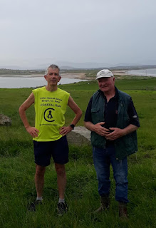
| Frank Cormack and family |
He also informs me that I have only one kilometre to go to my finish point at Ballycroy Visitor Centre which is great to hear. At the centre I enjoy a lovely lunch (delicious quiche salad) with Maureen and Brian.
Inisbiggle
Island
 |
| Map of Inis Bigil - island that's shaped like a horse |
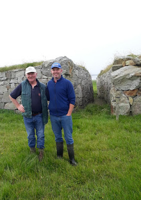
I had passed a sign earlier for Inis Bigil, just before Ballycroy and after lunch I suggested to Maureen that we drive down to the pier. At the harbour we noticed people heading over to the island in a small boat. We mentioned to someone at the pier that we were curious about getting across to Inis Bigil and the next thing he shouted to the boat men ''these people want to go too''. The boat turned around and we squeezed in. The two boatmen, Michael and Timmy Leneghan kindly took us on a magical trip over to the island.
 |
| The Leneghan brothers |
 |
| Brian on boat to Inis Bigil |
The brothers are among eighteen people who still live on Inis Bigil. The island itself is tucked into a secluded bay, with Achill on the west side and Annagh Island on the east side. It’s surrounded by hills, valleys and mountains. I was wearing a Clifton shirt (I usually bring three pairs with me!) and the two Leneghan brothers had heard me on MidWest Redio and refused to take any money for the trip. They also gave a donation to Clifton School, as did a man called David who we met at the pier. He was the man who shouted at the boat to return. Maureen, Brian and I spent a delightful 90 minutes exploring the beautiful island.
 |
| Maureen at (closed) Primary School on Inis Bigil |
 |
| Interdenominational Church on Inis Bigil |
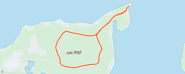
It is possible to drive (or run) across to the island but only when there are Spring Tides (extreme low tides). This crossing can be made from the south east side of the island and by driving through (or around) Annagh Island on the east side. It can only be done a few times of the year and should only be attempted with a local guide. Maybe some day I’ll come back and run across at low tide.
Stage 57: Revisited: Inis Bigil and Annagh Island: Friday 1 September 2023
‘’The legacy of ‘An Tailliur Gorm’ will live on but who will be left to share Inis Bigil’s poetry and stories to our future generation’’ (from video ‘A dying Culture’)
 |
| Crossing Annagh Island to reach Inis Bigil where I got the boat to Doran's Point |
I did go back! I convinced Maureen and Brian to join me on a return trip to Co. Mayo. The plan was to visit two tidal islands, Inis Bigil and Bartragh. This weekend there is a super blue moon, which will not be seen again for another 14 years, and we haven’t had one since 2009. Super moons occur when the moon passes its perigee, or the point that takes it closest to the earth. This makes it look 14% bigger compared to its furthest point away. We also know that the moon affects the tides, and a full moon means a very high tide and more importantly for me, an extremely low tide. Therefore, this weekend was the perfect opportunity to reach these islands.
 |
| Brian at Ballycroy Visitor Centre |
However, the day didn’t start well. We were staying in Ballina and woke up to a very foggy morning. That wasn’t good news as I knew I would be covering rough terrain and running along open sands with no markers. I had to be able to see exactly where I was going. Still, I knew low tide wasn’t until 1.30pm so there was time for the fog to clear. About 10.00am the sun was trying to make an appearance and for the next hour or two there was a Fog v Sun battle. Thankfully the sun eventually came out on top. We left Ballina and drove south towards Ballycroy. About a mile south of the village we took a right turn at a small crossroads. This was the road that I covered on my original coastal run. We came to a small crossroads with a sign pointing straight ahead for Bellacragher Boat Club. In my original Stage 57, I ran down to the sailing club but this time we took a right turn and headed west to the shore and to an area called Claggan, Ballycroy.
 |
| Running down to Claggan |
It has turned out to be a beautiful sunny day. It’s still only 12.15pm so we’re a good hour before low tide. The plan is for me to try to walk across the narrow channel to Annagh Island, run for about a mile across that island, along a trail if I can find it. Then cross over the open sand (another mile) to reach Inis Bigil Island. Easier, said than done and a warning - please be very careful, if you’re attempting this! The problem was getting across the channel to Annagh Island. Even at 1.00pm it still looked too risky. I was able to walk along a sand bank that took me closer to the island but then the water was getting deeper and there was also a strong current. Maureen, Brian and I waited and waited - and eventually saw the tide slowly recede.
 |
| Pointing out Croghaun Hill to Brian |
 |
| Wondering if I'll ever get across to Annagh Island |
At 1.30 it looked like the tide was still going out. At 2.00pm, we figured it was at its lowest and I could wade across to Annagh Island with the water just above my knees. The problem would be getting back again if I ran all the way to Inis Bigil, which was two miles away. As I didn’t want to risk crossing this narrow channel again, I made the decision that I would run all the way through Annagh Island to Inis Bigil and hopefully get a boat back from the north side of the island to the mainland at Doran’s Point. So, I said goodbye to Maureen and Brian and arranged to meet them later.
 |
| Arriving on Annagh Island and I've found the trail |
Having finally arrived onto Annagh Island I felt a sense of excitement to be on this strange isle that hardly gets a mention anywhere. I had read about cars sometimes crossing over from here and I knew from the OS map that there was a trail through the island. I found the trail quickly enough and started running. After a while I was amazed to pass a modern house with a jeep outside. There didn’t seem to be anybody there – just a few sheep who scattered at my arrival. I learned later that the house was owned by a German. He’s the only person living on the island. He was probably out fishing, making the most of a beautiful day like today.
 |
| House on Annagh Island |
 |
| Still following the trail heading northwest |
I continued on the trail, passing a forest on my left and later meeting some more sheep who stared at me in amazement. I eventually arrived on the west shore of the island. It was another good mile across a wet and sandy beach before I finally arrived onto the SE corner of Inis Bigil.
 |
| Reaching the west side of Annagh Island |
 |
| View of Slievemore, Achill from Annagh Island |
 |
| Ruins of house on Annagh Island |
It was rough going as I ploughed through a few fields on Inis Bigil. I finally reached a path that brought me to the Church. As I had been here in July 2021, it was familiar to me. I knew I wasn’t too far from the northern pier where I hoped I could get a boat across to the mainland.
 |
| I recognised the church on Inis Bigil as I'd been here in 2021 |
However, there was nobody at all about at Inis Bigil pier, just two empty boats. I wondered if I had any navigational skills at all, I would have borrowed one of the boats and made it across to the mainland. Meanwhile Maureen had reached the pier on the mainland. She rang me to say that it was deserted there too at that harbour. I waited on my side but still nobody turned up.
 |
| Two empty boats at Inis Bigil Pier |
 |
| View of Annagh Island from Inis Bigil |
Luckily for me I had remembered the Lenaghan brothers bringing us across to Inis Bigil in July 2021. I was able to google on my phone and get their mobile number. Michael answered the phone immediately, and I told him my story. As he was already on the island, he promised he would be with me in twenty minutes. He was true to his word. Fifteen minutes later the two Lenaghan brothers came to the rescue and took me in their boat back to the mainland. It is such an amazing journey crossing from Inis Bigil, especially on a beautiful day like today.
 |
| Michael Lenaghan and his brother to the rescue |
 |
| Arriving back on mainland to meet Maureen & Brian |
The sea was calm, and in this secluded bay, we were surrounded on all sides by the Mayo hills and mountains. The Lenaghan brothers treated me like the most important person in the world. As I sat in their boat, I felt like a king. I marvelled at the beauty around me. It reminded me of the song about ‘Bonnie Prince Charlie’ who escaped to Skye after the defeat of the Jacobite Rising in 1745.
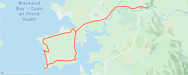
Stage 58
Co. Mayo: Ballycroy to Achill Sound
Sunday 29 August 2021
37km
or 23miles

It was back to Ballycroy National Park again to start todays run. I left Maureen and Brian and followed the road towards Inisbiggle Pier but took a left turn this time sticking to the quiet country coastal road.
 |
| At Ballycroy National Park |
I followed the signs south through this (Drumgollagh) area towards Bellacragher Boat Club and what a magical place I found. There was absolutely nobody here at this secluded oasis on a lovely Sunday morning. Then I saw a sign for a ‘Solar walk’ which guided me over a wee bridge and onto an island (it doesn’t seem to have a name so I’m calling it Bellacragher Island).
 |
| Trail running through 'Bellacragher' Island |
I followed a beautiful trail through the island with Achill Sound facing me across the narrow bay. On my solar walk, I passed signs for Venus and Pluto and I felt like I could have been anywhere in the universe.

Still no matter how remote you think you might be in Mayo, you'll always spot the odd green and red Mayo flag. Excitement is already building up for the All-Ireland Final in two weeks!
 |
| Start of Solar Walk at Venus |
 |
| End of Solar Walk at Pluto |
It’s almost a shame to leave this lonely but lovely spot. Reluctantly I return to the crossroads at the top of the hill, take a right and then join up with the main N59 road. The sign said 9km to Mallaranny (Mulranny). I have an opportunity to leave the main road after about 3km and join the ‘Claggan Mountain Coastal Trail’. I was tempted to follow this boardwalk even though I knew I would have to rough it at the end (through the bog) to get back onto the main road. (Maureen, Brian and I did return here later and walked along the boardwalk. In hindsight I think I could have managed to rough it as the weather has been quite dry over the last week or so).
 |
| At Claggan Mountain Coastal boardwalk |
As I got closer to Mulranny, the road got steeper as it wound its way around Claggan Mountain. The front cover of my book says ‘a running and sometimes walking adventure’ and this was definitely the ‘sometimes walking’ part. Still, I had the perfect downhill run at the end to Mulranny Park Hotel to meet Maureen and Brian. We sat for a while outside the hotel and then the three of us walked for a while along the Greenway towards Achill. The Great Western Greenway follows the old railway line from Westport to Achill and this section from Mulranny to Achill is the most picturesque.
 |
| On Greenway just outside Mulranny |
 |
| On Greenway with Bellacragher Bay behind |
This was probably my fourth time on this part of the Greenway
and I would highly recommend it. Such a beautiful route whether your cycling, running or walking along
this 13k trail. It’s very flat, away from any roads and so quiet and peaceful with
beautiful views across Bellacragher Bay. This stretch of the Greenway covers
the north coast of the Currane Peninsula and finishes just before the bridge on Achill
Island. (it's recently been extended further into Achill). After a mile or two, Maureen and Brian turned back
but I continued running towards Achill. The last time I cycled along here it became very windy as I got close to Achill. I know this area is called Tonragee, which translates as 'backside to the wind'. Thankfully there's not even a breeze today and it's not long before I arrive in Achill with Stage 58 completed.
The following morning we checked out of the B&B. We stayed three nights with Evelyn but when she heard about the Clifton Coastal Run she only charged us for two nights. Therefore, we donated the price of one night’s accommodation to Clifton School. Thank you Evelyn and thank you to her friend, Ciaran Moran who also donated.
 |
| With Evelyn outside B&B in Bangor Erris |
 |
| At the Crying Stone in Bangor Erris |
Laherdaun
(Leath Ardan - meaning half the hill)
And we’re still reluctant to leave this beautiful area! Driving back to Ballina we take a right turn at Crossmolina and after about 9km we arrive in Laherdaun. There’s so much history and interest in this one small village. As you drive towards Laherdaun the first thing you’ll notice is towering Nephin which is the highest stand-alone mountain in Ireland. It’s over 800 metres high. We didn’t really intend to go all the way to the top, but as it was such a dry day we kept climbing. Brian had so much energy and had no issues in going all the way to the summit. We met a young couple Natasha and Peter and enjoyed their company over the final stages to the top.
 |
| Brian with Natasha & Peter on top of Nephin |
 |
| Brian with his well-deserved certificate for climbing Nephin |
Brian was first to the top and we enjoyed the perfect views looking down on Lough Conn and the lovely valleys and hills below. Looking west and north we can even see across to the Atlantic coastline. We’re really in the middle (and on top) of Co. Mayo. However, coming down the mountain was not so easy. Trying to slowly manoeuvre through big rocks made it quite tricky and dangerous in parts. Brian was both cautious and nervous, but we took our time. I was so proud of him and he deserved his officially signed certificate that he received from Barretts shop in the village.

Laherdaun has a sad history as fourteen young emigrants from the parish boarded the famous Titantic at Cobh in Co. Cork. Only three survived the ill-fated journey. In the local church, every year on April 15 at 2.20am, eleven sombre tones ring out for those who died and three thundering strikes for the three women who survived. There is a beautiful memorial garden in the village with details about all these young people who boarded the Titanic.
 |
| Remembering Laherdaun eleven lost on Titanic |
In 1798 General Humbert’s forces passed through Laherdaun on their way to Castlebar. (I referred to Humbert in more detail in Stage 47). The small band of French forces deceived the British by taking this back road from Ballina through Laherdaun to Castlebar. On leaving Ballina, Humbert and his men made lots of commotion and noise as they pretended to take the main road to Ballina, but then they doubled back in silence and took the quieter road west of Lough Conn. Humbert's small army of men arrived in Laherdaun at midnight and were lucky to have the help of a local priest, Father Andrew Conroy. Fr. Conroy had spent time at a seminary in Nantes and so had a good knowledge of French and was able to provide them with food and give important directions to Castlebar. Humbert and his men, although outnumbered by three to one, won a famous battle in Castlebar. However, later Father Conroy was arrested, tried and executed by the British.