|
| STAGE 42-44: With Maureen & Brian on Streedagh beach |
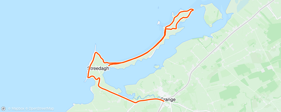
Stage 42: Revisited: Streedagh Beach and Conor’s Island
Saturday 15 February 2020
15 km or 9.3 miles
‘’To all the friends who met me there, with hearts so warm and true. To each and all, a fond farewell, sweet Dernish Isle, adieu’’ (written by an anonymous emigrant from Dernish island, Co. Sligo)
My plan today was to tackle Streedagh beach (near Grange) and
run along that long, thin peninsula as far as Dernish Island. I knew that low tide
was around 4.00pm so it worked out really well in the end as the rain seemed to
have died down by then. It had been a mild winter up to now but in the last week there’s been two (named) storms. Storm Ciara bombarded the coast last weekend and this weekend Storm Dennis was doing his best to cause havoc. I did think about postponing my coastal run but, as it was half-term, it would have been difficult. So, on the Saturday, Maureen, Brian and I drove down to Sligo, through the wind, rain and floods. It poured rain all day, but thankfully it was beginning to ease off, just as we were driving into Sligo town around 3.00pm.
 |
| View across to Streedagh and Conors Island |
We arrived at Grange village and drove directly to
nearby Streedagh beach and parked our car there. Maureen, Brian and I then
began walking along the strand.
 |
| Brian at the Streedagh beach sign |
 |
| Walking on Streedagh Strand |
The three of us walked together the whole
way along the long beach as far as the tiny, Blackrock Island. I then carried
on running on my own onto Conor’s Island. It's not an island anymore but on an 1837 map it was. Since then a sandbank has connected the island to the mainland. At this stage Maureen and Brian
turned around and we arranged to meet later in Moran’s Bar in Grange.
 |
| Tiny Blackrock Island on Streedagh Beach |
I kept running through the sand dunes all the way
along Conor’s Island until I was very close to Dernish Island across the rocks. It was
almost low tide now, but it would have been a real struggle to get across those
rocks to Dernish. There was no proper causeway to the island and I reckon it
would not be very safe to even attempt to cross. In the distance I could
see Classiebawn Castle in Mullaghmore and in fact the original site for the
Castle was actually on Dernish Island.
 |
| View across to Dernish Island |
I turned around and headed back,
running on the south side of Conor’s Island. In a field in the distance I
spotted about 10 or 12 horses and strangely the animals seem to spot me too! And
then I noticed one or two of the horses starting to head in my direction. I sprinted over the hills almost afraid to look behind as the young thoroughbreds chased after me. I was so relieved to be back on Streedagh Beach again.
 |
| Surfing at Streedagh despite Storm Dennis |
 |
| Spanish Armada - 3 ships sunk off Streedagh Beach |
Back on Streedagh Strand I couldn’t help reflecting on the
historical significance of this area. Three Ships of the Spanish Armada crashed
here in heavy storms back in 1588. The story of the Armada seems to be
following me all along the Irish coast!
After running along the beach again I followed the
headland south all the way around, through fields and mud. Storm Dennis seemed to
have picked up again and the wild Atlantic was battling away. I eventually made
it back onto the road and soon I was enjoying some Cidona and Taytos (with Maureen and Brian) in Moran’s
Pub in Grange!
 |
| Back In Grange in front of Spanish Armada Mural |
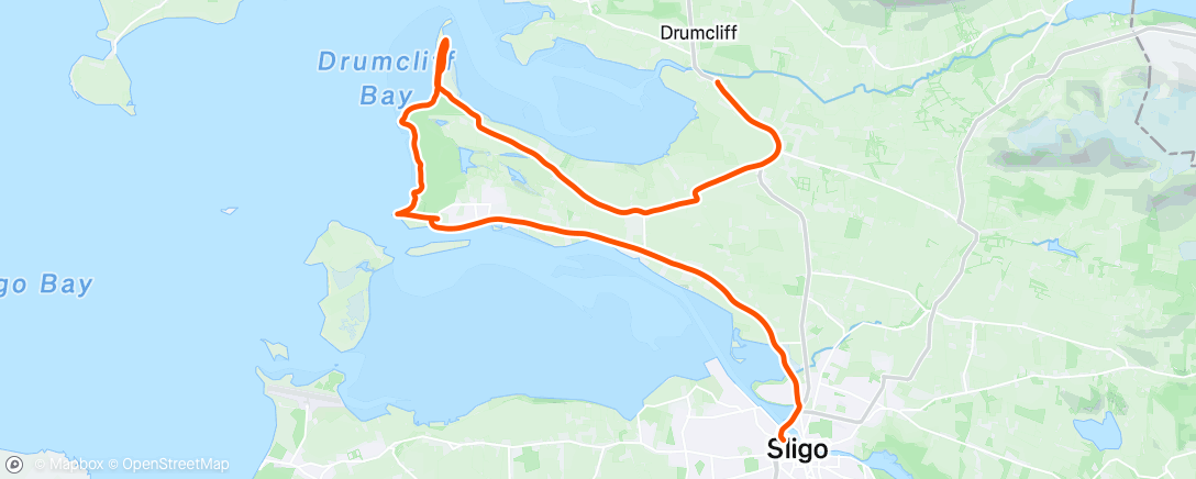
Stage 43
Co. Sligo: Drumcliff to Sligo Town
Sunday 16 February 2020
22 km or 14 miles
We stayed the night in the Clayton Hotel
in Sligo town. In the morning, Maureen drove me to Drumcliff village, and we
paused at Yeats Grave (casting a cold eye, on life and death!).
 |
| At Cafe in Drumcliff with Yeats picture |
On Facebook, I
had put up a message on the ‘Mountain & Hill Running in Connacht’ page asking,
if anyone wanted to join me today. Nobody took up the offer, so I headed off, south
along the N15. Just after passing through Rathcormack, I took a right turn. There
was a dark sky above but somehow the rain never materialised.
 |
| I took the 'less travelled' right turn to Lower Rosses. |
I followed the
signs for Lower Rosses and eventually, as I was getting close to the coast, I
spotted a lane (right) that took me down to the shore. I was able to stick to
the coast along the long narrow peninsula all the way to the end.
 |
| At top of Rosses Point |
 |
| Trying to stand still! |
I could clearly see Lissadell House across the bay and of course Ben Bulben to
my right. When I turned around to head back south towards Rosses Point, I faced
storm Dennis and the wild Atlantic wind in all its glory. I was lucky I had my hat
and snood to protect me from the sand blowing in from the shore. Shortly I
reached Rosses Point Golf Course – no mad golfers out today! I kept struggling
against the strong wind and to make matters worse, the rain now arrived. However,
I could now see the pier at Rosses Point and civilisation.
I decided I deserved
a break and walked into the first hostelry I could find in Rosses Point. It was
the Yeats County Hotel (YCH). I ordered a coffee and water and headed towards
the open fire.
 |
| Waiting for clothes to dry at Yeats County Hotel in Rosses Point |
Here I got talking to some visitors from Armagh and they kindly
let me dry some of my clothes by the fire while I drank my coffee. When I was
leaving, one of them (Declan McAlinden) gave me a donation of £20 for Clifton
School - thank you Declan and friends!
 |
| Wreck and Oyster Island |
From here It was a straight run into Sligo
Town - the sign said 8km – but it was still a tough ending to today’s
adventure. I continued on, eventually crossing the river Garvoge into Sligo town to
meet Maureen and Brian.
 |
| Famine Memorial, Sligo Town |
 |
| Famine Letter |
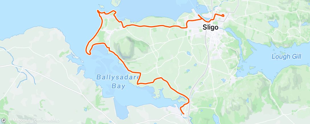
Stage 44
Co. Sligo: Sligo Town to Ballysadare
Monday 17 February 2020
31 km or 19 miles
This morning I had an early breakfast
and left the Clayton Hotel in Sligo Town about 8.30am. (Maureen and Brian staying
in bed). I think Storm Dennis had died down and I only suffered one heavy
shower today.
 |
| Clayton Hotel - it used to be a Hospital |
Sticking by the coast as always, I followed the dock road in
Sligo after I crossed the river. This wasn’t easy and at one stage I
had to double back on myself. Eventually, I did get onto to the main Strandhill
road and had to run along the main R292 for quite a few miles.
 |
| Start of Killaspugbrone Loop |
As I came into Strandhill,
I was lucky to spot a sign pointing towards the ‘Killaspugbrone Loop’. This
was a lovely path that led me down to the shore and took me past Sligo Airport.
I followed the coast all the way around and reached the only house in this area. Around the back of the building, I come to a high wall. Once climbing over that, I landed on a beach that I was able to run on. At the end of the strand I could spot some ruins and headstones.
 |
| Ancient Graveyard at northern tip of Strandhill |
 |
| Killaspugbrone Graveyard |
This was the ancient Killaspugbrone
church and graveyard that St. Patrick attended and apparently, he crossed over
to Coney Island from here. Although this seems to be the closest point to
Coney Island, there is actually a proper causeway further east which gives easy
access to the island at low tide.
After leaving the old churchyard I was still
able to follow a grassy path to the tip of the peninsula and loop
around back towards the village of Strandhill.
 |
| Still following the 'loop' sign! |
The wind wasn’t as strong as yesterday, but it
was still a struggle! I eventually arrived back to civilisation again and this
time I stopped at Shells Café in Strandhill.
 |
| Meeting Brian at Strandhill |
Shortly Maureen and Brian arrived,
and we enjoyed some coffee and scones in the cafe. Soon I was running again – this time, south
towards the sand dunes. As it was high tide there was no possibility to run on the beach. Running through the dunes was a lovely run and brought me around the bottom of Strandhill
peninsula.
 |
| Sand dunes - south of Strandhill |
 |
| Nice soft path to run on |
I then came to Colleenamore beach. Not really sand for the feet
of the runner as it was too soft. At least the weather has brightened up.
 |
| On Colleenamore Beach |
 |
| I could do with seeing more of these 'You are here' signs! |
I left Colleenamore strand
and at the top of the road I took a right turn towards Ballysadare, following
the R292 for a few miles with Knockrea (Queen Maeve’s grave) on my left.
 |
| Knockrea (Queen Maeve's Grave) |
.
 |
| This is where you take a turn down to shore |
At a
sign for a Marian Shrine, I took a right turn towards the shore and then a left
just before I reached the coast. There was another rough trail to the right
after about a mile, which I should have taken – it would have brought me onto the
coast again and probably made my journey shorter.
 |
| 10k to go - this seems about right! |
In any case I got back on the
main Ballysadare road again. At this stage I was struggling – running three
days in a row was taking its toll – so I decided to walk the hills. Still,
nobody said this adventure was going to be easy – and soon I had reached
Ballysadare, my final destination for this weekend.
 |
| At last I've reached Ballysadare! |
Stage 44: Revisited: Co. Sligo's Coney Island
Sunday 20 September 2020
13 km or 8 miles
I knew that I needed a low tide to be able to run (or
walk) across to Coney Island and we got the perfect day to do this. I had
completed Stage 48 in NW Mayo the day before and I was so glad that Maureen and
Brian could join me today on a less strenuous adventure. We arrived at the
start of the causeway at 11.30am , about two hours before low tide. Our
first reaction was that the tide was still quite high - we definitely couldn’t
see any causeway! However after chatting to a few people we quickly realised that
it was quite safe to cross in our bare feet and what a lovely experience that
was. (much nicer than driving across, especially as we knew we had four hours
to return again)
 |
With shoes off before heading across to Coney Island
|
Coney Island is sometimes called Inishmulclohy. There are
a few similar named islands in Ireland as coney or coinin is really the Irish word for
rabbit. Apparently the New York Coney Island is called after Sligo’s Coney Island
as the sea-captain of a ship called the ‘Arethusa' (that used to sail between
Sligo and New York) noticed lots of rabbits on the New York island and it
reminded him of Sligo’s Coney Island.
 |
Half way across to island
|
 |
At Rock no.10 of 14 on way to Coney
|
It’s a good 2.5km across to the island from the mainland
and we had the most beautiful day to do this with Ben Bulben watching over us the whole time. There
are 14 (rock) markers about 150 metres a part to guide you on the way to the
island. On reaching Coney I put my running shoes on, left Maureen and
Brian, and ran clockwise (sea on my left) around the island. I continued along
by the shore, first running on soft sand and then on the grassy headland.
Eventually
I arrived at Carty’s Strand on the west side of the island
where I had arranged to meet Maureen and Brian again. Maureen gave me a drink
here and we watched the horses running on the strand.
 |
At Carty's Strand on Coney Island
|
I continued running on my
own around the rest of the island, first up through the big rocks and soon I
found a narrow grassy path. I could see a lighthouse on my left side (Blackrock
Lighthouse) and shortly I came on to another beach on the north side of the
island. I ran along the strand here until I came to the pier where again
I was reunited with Maureen and Brian. Looking across to Rosses Point we could
see the famous Metal Man across the bay (not exactly the Statue of Liberty but
he’s still 12 feet tall!).
 |
Looking across towards Metal Man and Rosses Point
|
 |
At the Pier on Coney Island
|
We still had plenty of time on the island and we were even able to
stop at Wards pub for some coffee and crisps for Brian before
walking slowly across the strand back to the mainland. It was such a lovely day
that will forever live in my memory. Bye, bye Coney Island.