Thursday 2 November 2023

Stage 90: Co. Clare: New Quay to Ballyvaughan: Thurs 2 November 2023: 23.03km or 14.31miles    

And some time make the time to drive out west into County Clare, along the Flaggy Shore, in September or October, when the wind and the light are working off each other’’, From 'Postscript' by Seamus Heaney

At New Quay outside Linnane's Pub

I deliberately made sure to cover this area in Autumn just to check out what Seamus Heaney was talking about. (didn't quite make October). The great Irish poet died just ten years ago, and ‘Postscript’ is one of his famous poems. Compared to some of the spectacular scenery I’ve seen, there’s nothing special about the flaggy shore but in fairness to Heaney he’s talking more about the wind, the light, and the contrasts. Today I felt the wild Atlantic wind in all its glory but at least it was dry for most of the morning.

The Flaggy Shore, Co. Clare
I parked my car at New Quay outside Linnane’s Bar looking across towards Aughinish Island. The weather reports highlighted Storm Ciaran and gave a yellow warning for six counties, but it looked like north Clare was escaping the worst. Still, a strong westerly wind was blowing in my face as I ran along the flaggy shore.

‘’the ocean on one side is wild with foam and glitter, and inland among stones
the surface of a slate-grey lake is lit by the earthed lightning of a flock of swans,

Mount Vernon House
Along the flaggy shore, I pass Mount Vernon. This house was built originally by Colonel William Persie to celebrate his friendship with George Washington. The original Mount Vernon in Virginia, USA was the estate of Washington and it is where the first American president is buried. The Irish Mount Vernon was eventually left to Persie's descendant, Lady Gregory. She entertained all the great writers here including Yeats, Russell, O'Casey, Synge and George Bernard Shaw. 
Towards the end of the coastal road, I spotted the ‘slate-grey lake’. I knew exactly what Heaney was saying and perfectly understood the contrast he was writing about. I even spotted in the distance ‘the earthed lighting of a flock of swans’.

Looking across to cliffs on Aughinish Island

Probably too early and cold for ice cream!
At CafĂ© Linnalla, the wee ice cream shop, I was able to take a short cut through their grounds. I continued west along a country road towards Finavarra and followed it to the end as far as the Martello Tower. This is the third tower I’ve passed in Galway Bay. These Martello Towers were built to defend strategic points and usually built in pairs (or triplicate in this case) so that the invading fleet would come under crossfire from different locations. 

Martello Tower at Finavarra
Martello Towers get their name from a tower on Corsica called Torra di Mortella. The tower in Corsica withstood severe bombardment from the British Navy. The British were so impressed that they copied the design and built similar structures in the UK and Ireland. Napoleon was born in Corsica and spent his early years there. Ironically the Martello towers in UK and Ireland were built as a defence against Napoleon’s army, which never arrived.

Following the coast road around

On the tower itself, I could see the remains of a rope which is used for getting into the upper door. Again, as with the other Martello Towers, I resisted the temptation to climb up.

On the way back, I passed Scanlans Island. Unfortunately, it was high tide, and I could see that the small island was not accessible from the west side. Also, with so much rain over the last few weeks it would not have been a good idea to try to cross the causeway. I hope to come back and circle the island again. I followed the road around and shortly came to the O’Dalaigh monument on a small hill by the shore. 

O'Dalaigh Monument

 Co. Clare and the O’Dalaigh bards

The O’Dalaighs (or Dalys) were ancient bards and part of the Bardic Schools for poets which gave the equivalent of a university education right up to the 17th century. In social rank, poets were placed below kings but above all others. Maybe it was no coincidence that Seamus Heaney was inspired to write his ‘Flaggy Shore’ poem just around the corner from the O’Dalaigh monument.

Co. Clare always had its own culture probably because of its unique geographical location. The River Shannon and the Atlantic Ocean cut off the county from most of its neighbours. It’s the only Munster County west of the Shannon and I always believed Clare would be more at home in the province of Connacht. I’m sure Oliver Cromwell also meant to include Clare in his ‘to hell or to Connacht’ comment when he banished old Irish lords and landowners to the west.

 I follow the road south and loop around the bay at Bell Harbour (Beal an Chloga). I think the name Bell or Chloga relates to a man of that name who drowned in the harbour. 

Shanmuckinish Castle

Close up shows castle in ruins

I’m running along the main road now (N67), but traffic is quite light. Soon I see a castle in the distance. It’s situated on a small peninsula that’s jutting out into Pouldoody Bay. It’s called Shanmuckinish Castle which even gets a mention in the ‘The Annals of the Four Masters’ in 1584. Back then Turlough, son of McLoughlin O’Loughlin, owner of the castle, was taken prisoner and later put to death. When I reach the castle I notice that it is fenced off and that the rear of the fortress is in ruins. Leaving the castle, I could have followed a coastal trail, but I could see on my OS map that the path didn’t go very far. Also, with all the rain we’ve had I didn’t fancy roughing it along the shore, so I kept to the main road.

View from Castle

I continued along the N67 and at Bishopsquarter I run down to the coast. There was a trail through a grassy area which I was able to run along, make a loop and come back along the coast. I enjoyed this interlude as I had been running on roads all day. There is nothing like the surface of a grassy trail or a sandy beach. 

Bishopsquarter 

Back on the main road the rain started to come down, so I didn’t stop at the Bishopsquarter graveyard. I carried on to Ballyvaughan, took a right turn and ran as far as my finish point at the Old Pier. (There used to be a regular connection from here to the Aran Island). 

Finally at Ballyvaughan Pier

Quotation on Ballyvaughan Pier

Meeting up at Ballyvaughan Pier
It was still only 11.00am when I reach the harbour and the rain has stopped. Even though it was a shorter run today that west wind made it hard work. Shortly my chauffeurs (Aideen, Maureen, and Brian) arrive and we all adjourn to Monks pub. Stage 90 Complete

Saturday 16 September 2023

 Stage 89 Kinvara to New Quay 

Total distance (around Ulster and Connacht): 3,335km (2,072miles)

Stage 89

Kinvara, Co. Galway to New Quay, Co. Clare 

Friday 15 Sept 2023

 37.96km or 23.6miles

‘’Not time, nor tide, nor waters wide could wean my heart away. Forever true, it flies to you, my own dear Galway Bay’ 

Those lines are from the original ‘Galway Bay’ and the best rendition is sung by the ‘voice of traditional music’ herself, Dolores Keane. The song was composed by Frank Fahy (1854-1935) a man who was native of Kinvara. As suspected he wrote it when he was an emigrant with the heart-breaking longing for his ‘dear old Galway Bay’


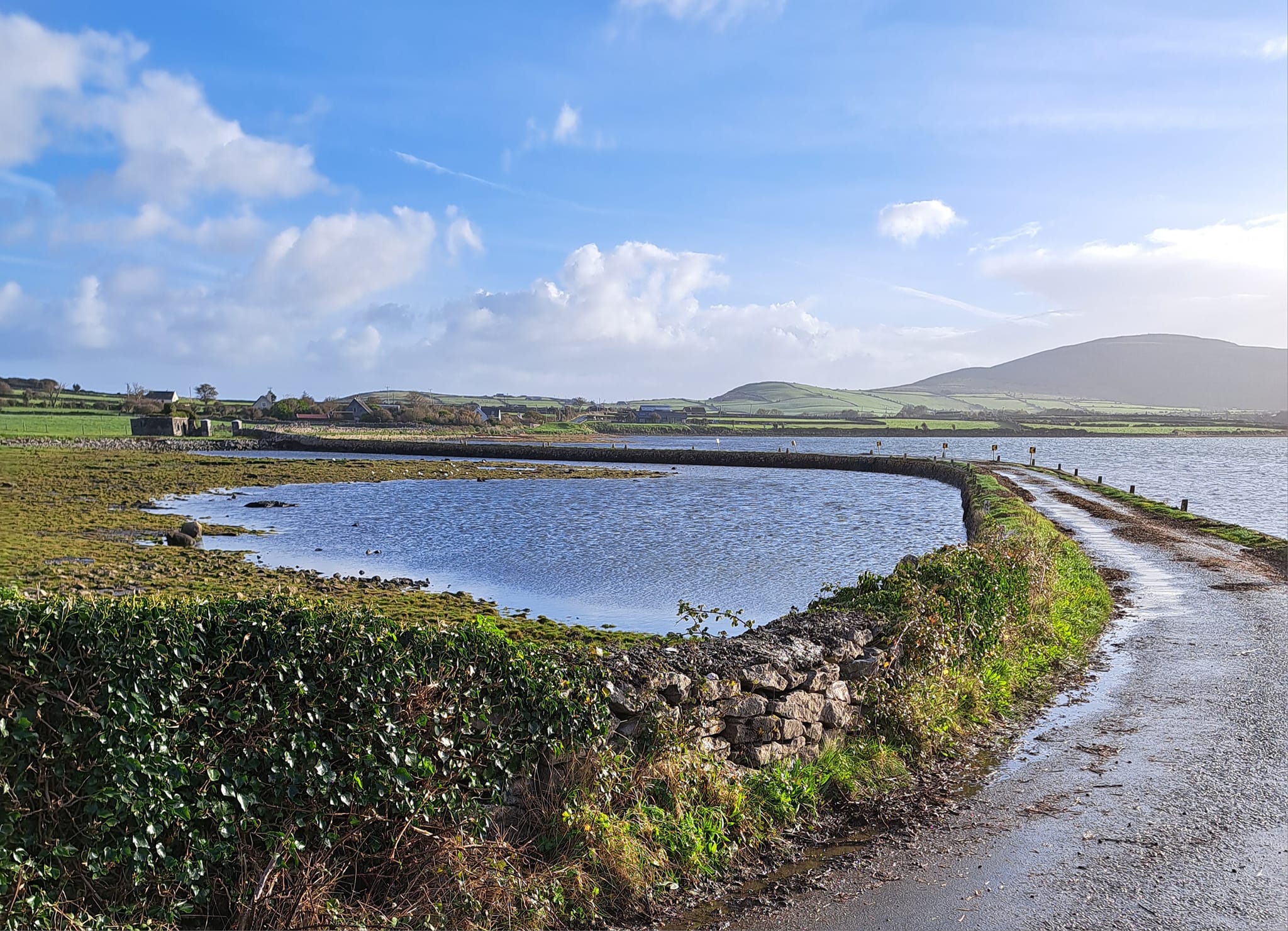
Kinvara to New Quay via Aughinish Island

The forecast for today was all about rain and I was preparing myself for the worst and even thinking of a plan B if I didn’t get as far as New Quay. However, watching the RTE weather the night before I was given some hope. There seemed to be a diagonal ridge across the country that was going to experience heavy rain with even a ‘yellow warning’ for eleven counties. Lucky for me, counties Galway or Clare were not included in the list. Still, it was a cloudy day but no rain at all until I was almost finished for the day.     

I returned to the pier at Kinvara where I finished my run in July and headed west. After one kilometre out from town I pass St Colman’s Church and take a right and then another right down towards Crushoa Pier. 

Crushoa Pier

People told ghost stories about this area, but these tales were probably made up by locals to deter people stealing valuable oysters from here and from nearby Mulroney’s Island. As it’s only 8.30am I know it is still high tide and so I don’t even attempt to get across to the island.

It is also too wet and boggy to stay by the coast so I double back and then take another right, heading north to ‘Tawnagh East’. Before coming to the end of this road I take a left along a boreen. Even when that trail comes to an end I’m able to follow a grassy path and run across an open field to the road. This is a shortcut rather than going by Nogra and I reckon in olden times, people followed this same route. I join up with the main road heading north just in time before it crosses over the sea towards Doorus. I don’t run to Tracht beach but instead take another right and immediately come to Doorus House. 

Crossing over to Doorus

Too late to make an offer - Sale Agreed

Doorus House

I could have easily missed this building as it now seems to be in private ownership. The house was originally built in 1810 by a French man, de Basterot. Towards the end of the nineteenth century the family were friendly with Yeats and Lady Gregory. After discussions in the house the idea for the Abbey Theatre was conceived here in Doorus House on the shores of Galway Bay. 

Doorus House with interesting history 

In 1961 the house was given over to ‘An Oige’ the Irish Youth Hostel Associated. I actually stayed here some time in the 1980’s when all the youth hostels in Ireland were in rural locations. In those days you could stay in an ‘Oige Hostel’ for a small charge, but you were also given a chore to do. I remember one of my tasks in Doorus House was to sweep the stairs.  

Parkmore Graveyard & Medieval Church

Just another five hundred metres after Doorus House I see a sign for Parkmore cemetery. A grassy dirt track takes me down to an ancient graveyard with a medieval church. 

Grave (or mausoleum) for the de Basterot family  

I spot a huge grave or mausoleum for the afore mentioned de Basterot clann. On my OS map it looks like there is a road at the back of the cemetery, but I can’t find it. 

The only way to reach the road from the cemetery

I end up running through a narrow grassy path and climbing into a farm yard before I find the lane. I arrive down on the shore and decide to stay by the coast. It is quite muddy but there are tractor trails that give me confidence to stay on the shore.

I follow the coast all the way to Doorus Point and to Parkmore Harbour. In Irish it is called ‘Caladh na Sceiche’ which means ‘hidden harbour’. The pier was built in 1881 when the main harbour in Kinvara was falling into disrepair and becoming inaccessible because of tides. As part of the post-famine relief, Parkmore Pier was financed by the Canadian government.

In my wisdom I decide to stay by the shore to reach Tracht Beach. What started off as a lovely grassy path, soon disappeared and then I was struggling through rocks that got bigger and bigger. It turned out to be my slowest kilometre of the day at 11.38 minutes. I was so relieved to finally arrive at Tracht. 

A coastal path to Tracht that disappears quickly 

Tracht beach.

Saint Ciaran studied under St Enda on Aran Islands and when he went to set up his own monastery at Tracht ‘a miraculous road opened up on the seabed’  There’s no sign of that miraculous road today but I do see Island Eddy to the north. At low tide on Island Eddy there is a type of path or sand bank that becomes visible and maybe this was the miraculous road that Saint Ciaran was talking about. In fairness to Ciaran, he did achieve a lot in his young life. In 544 he founded, Clonmacnoise, a very famous monastery on the banks of the river Shannon. That became a very important place of learning, a university of its time with students attending from all over Europe. Clonmacnoise includes a Cathedral, two round Towers, three high crosses and nine Churches.

Saint Ciaran statue near Tracht Beach

On Tracht strand I don’t envy three ladies that I see going in for a swim. I carry on running along the coast and this section, as far as Lynch’s Pier, was very achievable along a shingle beach. The harbour I shortly arrive at is sometimes called Paradise Harbour but it doesn’t seem very exotic on a dull cloudy day like today. I’m not sure if the pier is used much these days as its strangely covered in grass. 

Lynch's or Paradise Pier  

I see a coastal trail heading west which I was tempted to take but I notice on my OS map that it disappears after a few hundred metres. Instead, I head slightly inland and followed a coastal road that brings me all the way to Aughinish Island. I cross the long causeway and attempt to circle the island, as usual with the sea on my right.

Passing St. Ciaran's Church - on the way to Aughinish

Aughinish Island

This causeway to the island was built in 1811 to service troops at the Martello Tower. I spot the tower straight away as I begin to cross the sea and the building is my first port of call on the other side. I had seen a Martello Tower near Rossaveal but this one seems much bigger. There are also a few additions to it; a metal stairway up to the doorway and two chimneys at the top, which look very peculiar.

Crossing onto Aughinish with Martello Tower in distance

Martello Tower on Aughinish Island

Stairway to the tower
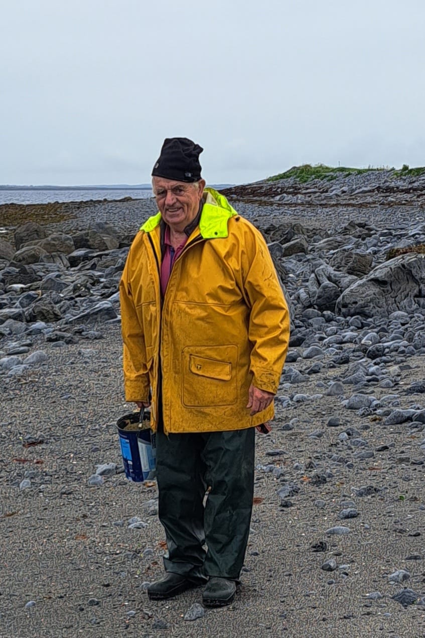
I leave the tower and shortly I see a man with a bucket. He tells me that he is collecting periwinkles. These marine creatures are really sea-snails and are very common on the rocky shores of Co. Clare. He seems to think that it’s achievable for me stay by the coast and circle the island. 

Collecting periwinkles on Aughinish

However, as I’m running along the north shore, the terrain is getting rougher. There are high cliffs on the western tip of the island which make it impossible to stay by the coast. I climb up onto the headland and there’s a long meadow in front of me. I see a herd of cattle in another field and try to avoid them but one or two spot me and start running in my direction. Lucky for me there are electric fences separating the fields. Shortly I climb a gate, feeling relieved to be on a trail away from the cows. I follow this boreen for a while and take a right at a T junction that brings me down to the coast on the southern side of the island.      

The story is that Aughinish (Horse Island) was connected to the mainland near the Flaggy Shore until 1755. In that year there was a great tsunami in Portugal which even had an impact in the west of Ireland. I know Aughinish is officially in Co. Clare and that seems to back up the argument that it was originally connected to Co. Clare on the south side. Standing here on the island and looking across to New Quay about 200 metres away, I find it hard to believe that only 268 years ago that the island was connected to the mainland. Maybe 20,000 years ago! In any case the island is now linked to the mainland by a bridge on the east side, so to get to Aughinish in Co. Clare you must go through Co. Galway.

There was an abundance of fushia everywhere today 

There are muddy tractor trails along the southern shore of the island but it is achievable to stay by the coast. The writer Thomas Cook who I suspect was the famous travel agent, referred to this Redbank area with its coral weeds that have a reddish colour. He was here in 1842 and became quite excited when he saw some local ladies working on the shore. He commented as follows.   

It is not unusual to see one hundred and fifty girls employed on the oyster beds here, either sowing or arranging the shellfish. These young women form a picturesque corps of mermaids, when seen paddling in the shallow water, with red petticoats tucked up as high as their knees, and sometimes even higher.’  Steady on, Mr. Cook.

I leave the island (back into Co. Galway again) and follow a proper road along the coast. I pass the townland of Rinneen and at a small crossroads I was tempted to take a right turn down to the shore and try to make a short cut to the N67. However, I knew low tide wasn’t until 1.24pm so I continued straight. I pass near the Travellers Inn at Nogra, and eventually come back to the main road. I wasn’t looking forward to running on the N67 and it was every bit as difficult as I suspected. I’ve encountered some dodgy experiences on my coastal run but running along a narrow busy road like the N67 is more dangerous than anything else I’ve done. About halfway along here I come to a big sign that says, ‘Welcome to Co. Clare’. I realise that I’ve finally covered the whole coast of Connacht. However, I don’t have time to celebrate my achievement as I’m standing on the N67 and still have another 2.5k to go. A sign for Boston confuses me. No, I’m not hallucinating as there is a Boston in Co. Clare - it's only 15km from here. 

Crossing into the province of Munster

Boston, Co. Clare

I decide to get off the busy road and take a left up a steep hill (L1014) and then a right to follow a ‘green road’ which runs parallel to the N67. This trail is part of the route to Abbey Hill (Cnoc na Mainistreach) or Monastery Hill. It is great to be off the main road, but I’ve made more work for myself. I’ve already run 30km today and light misty rain is beginning to fall. In hindsight, taking this green hilly road wasn’t such a good idea. It seems to be taking me higher and higher up the mountain. I'm struggling up the hills and I've now added another 90 metres (or 300 feet) of elevation. Also, the spectacular views across the bay and over the Burren are, today covered in mist. 

I spot the main road down below and decide to make a deep descent through the steep fields. Once I’m back on the N67, I shortly I see the sign for New Quay (L1018). It’s still another 2k down the hill to Linnane’s Lobster Bar but at least I’m off the main road. Maureen, her sister Aideen and our Brian are already there sitting at the table in the restaurant. I join them and settle for some tasty Seabass, washed down with a pint of Guinness.   

Saturday 2 September 2023

Although I've reached Kinvara, Co. Galway on my coastal run (Stage 88), I needed to return and finish parts of the coast that I had missed earlier. Usually this is because the tide isn't far enough out to enable me to reach certain corners of the coast. So I have to go back! Also, I like the challenge of running or walking to islands, which are only accessible at low tide. This weekend I had the perfect weather and the perfect company. We've had such a miserable summer but the sun shone in all its glory in Co. Mayo.

Stage 57: Revisited: Inis Bigil and Annagh Island: Friday 1 September 2023

’The legacy of ‘An Tailliur Gorm’ will live on but who will be left to share Inis Bigil’s poetry and stories to our future generation’’ (from video ‘A dying Culture’)

Crossing Annagh Island to reach Inis Bigil where I got the boat to Doran's Point

I convinced Maureen and Brian to join me on a trip to Co. Mayo. The plan was to visit two tidal islands, Inis Bigil and Bartragh. This weekend there is a super blue moon, which will not be seen again for another 14 years, and we haven’t had one since 2009. Super moons occur when the moon passes its perigee, or the point that takes it closest to the earth. This makes it look 14% bigger compared to its furthest point away. We also know that the moon affects the tides, and a full moon means a very high tide and more importantly for me, an extremely low tide. Therefore, this weekend was the perfect opportunity to reach these islands.

Brian at Ballycroy Visitor Centre

However, the day didn’t start well. We were staying in Ballina and woke up to a very foggy morning. That wasn’t good news as I knew I would be covering rough terrain and running along open sands with no markers. I needn’t to see exactly where I was going. Still, I knew low tide wasn’t until 1.30pm so there was time for the fog to clear. About 10.00am the sun was trying to make an appearance and for the next hour or two there was a Fog v Sun battle. Thankfully the sun eventually came out on top. We left Ballina and drove south towards Ballycroy. About a mile south of the village we took a right turn at a small crossroads. This was the road that I covered on my original coastal run. We came to a small crossroads with a sign pointing straight ahead for Bellacragher Boat Club. In my original Stage 57, I ran down to the sailing club but this time we took a right turn and headed west to the shore and to an area called Claggan. 

Running down to Claggan 

It has turned out to be a beautiful sunny day. It’s still only 12.15pm so we’re a good hour before low tide. The plan is for me to try to walk across the narrow channel to Annagh Island, run for about a mile across that island, along a trail if I can find it. Then cross over the open sand (another mile) to reach Inis Bigil Island. Easier, said than done and a warning - please be very careful, if you’re attempting this! The problem was getting across the channel to Annagh Island. Even at 1.00pm it still looked too risky. I was able to walk along a sand bank that took me closer to the island but then the water was getting deeper and there was also a strong current. Maureen, Brian and I waited and waited  - and eventually saw the tide slowly recede. 

Pointing out Croghaun Hill to Brian

Wondering if I'll ever get across to Annagh Island

At 1.30 it looked like the tide was still going out. At 2.00pm, we figured it was at its lowest and I could wade across to Annagh Island with the water just above my knees. The problem would be getting back again if I ran all the way to Inis Bigil, which was two miles away. As I didn’t want to risk crossing this narrow channel again, I made the decision that I would run all the way through Annagh Island to Inis Bigil and hopefully get a boat back from the north side of the island to the mainland at Doran’s Point. So, I said goodbye to Maureen and Brian and arranged to meet them later.


Arriving on Annagh Island and I've found the trail

Having finally arrived onto Annagh Island I felt a sense of excitement to be on this strange isle that hardly gets a mention anywhere. I had read about cars sometimes crossing over from here and I knew from the OS map that there was a trail through the island. I found the trail quickly enough and started running. After a while I was amazed to pass a modern house with a jeep outside. There didn’t seem to be anybody there – just a few sheep who scattered at my arrival. I learned later that the house was owned by a German. He’s the only person living on the island. He was probably out fishing, making the most of a beautiful day like today. 

House on Annagh Island

Still following the trail heading northwest

I continued on the trail, passing a forest on my lefthand side and later meeting some more sheep who stared at me in amazement. I eventually arrived on the west shore of the island. It then it was another good mile across a wet and sandy beach before I finally arrived onto the SE corner of Inis Bigil.

Reaching the west side of Annagh Island

View of Slievemore, Achill from Annagh Island

Ruins of house on Annagh Island

I roughed it here on Inis Bigil for a while until reaching a path that brought me to the Church. As I had been here in July 2021, it was familiar to me. I knew I wasn’t too far from the northern pier where I hoped I could get a boat across to the mainland. 

I recognised the church on Inis Bigil as I'd been here in 2021

However, there was nobody at all about at Inis Bigil pier. There were two empty boats and I wondered if I had any navigational skills could I have borrowed a boat and made it across to the mainland. Meanwhile Maureen had reached the pier on the other side. She rang me to say that it was deserted there too at that harbour. I waited but still nobody turned up. 

Two empty boats at Inis Bigil Pier

View of Annagh Island from Inis Bigil

Luckily for me I had remembered the Lenaghan brothers bringing us across to Inis Bigil in July 2021. I was able to google and get their mobile number. Michael answered the phone, and I told him my story. He was already on the island and he promised he would be with me in 20 minutes. He was true to his word. Fifteen minutes later the two Lenaghan brothers came to the rescue and took me in their boat back to the mainland. It’s such an amazing journey crossing from Inis Bigil, especially on a beautiful day like today. 

Michael Lenaghan and his brother to the rescue

Arriving back on mainland to meet Maureen & Brian

The sea was calm, and in this secluded bay, we were surrounded on all sides by the Mayo hills and mountains. The Lenaghan brothers treated me like the most important person in the world. As I sat in their boat, I felt like a king. I marvelled at the beauty around me. It reminded me of the song about ‘Bonnie Prince Charlie’ who escaped to Skye after the defeat of the Jacobite Rising in 1745.

 ‘’Carry the lad that’s born to be King. Over the sea to Skye’’.


Stage  47 Revisited: Bartragh Island: Saturday 2 September

‘’We are safe here for a while together above the tides reach’’, Tony Hegarty’s poem about Bartragh.

Showing my run along the north shore of Bartragh Island

I had seen this island first from Enniscrone beach on the Sligo side (Stage 46) and then later from Ross Strand near Killala (Stage 47). I wasn’t sure if it was possible to run (or walk) across and I didn’t want to take any risks either. However, if it was achievable I needed to get there. My dilemma was solved by Denis Quinn from ‘Wild Atlantic Cultural Tours’ and we booked a trip across with him. It is the Moon’s gravitational pull that causes the tides and, as it was a full moon yesterday, it meant that there was a very low tide in North Mayo. 

Our team of SIX for today (with Aoife, Cassandra & Sean)

I was also privileged to have my old friend Sean Harte from Galway with us today. His daughter Aoife and her friend Cassandra also joined us. I have known Sean and Cassandra Beggan’s parents for over forty years. I was so pleased that they all came along. Such great company which added to the whole adventure. With Maureen and Brian, we now had a team of six. We arranged to meet our guide, Denis at 1.30pm in Killala and he then drove us a few miles away, to a townland called Ballockpark, which is about 1k south of Moyne Friary. From there we were able to walk across to Bartragh Island. I had told Denis about my Coastal Run, so I left the others for a while and ran ahead to the north side of the island and headed west along the beach. 

Heading up to Bartragh House

In my absence, the others visited the only house on the island. It was built by Kirkwood family in the 1830’s. In the 1940’s Claud Kirkwood inherited the house. He was a recluse (perfect place he found) and once was referred to in a newspaper article as 'the loneliest man in the world' . On one occasion he placed an advertisement in the local paper saying that the island was closed to visitors ‘Due to the thieving proclivities of certain individuals, Bartragh Island is now closed from this date, except with the written permission of Claude A. Kirkwood'. Just after the Second World War, Claud sold Bartragh to a man named Captain Verner. 

Captain Verner’s wife was a sister of the actress Joyce Redman, who was nominated for two academy awards. She entertained guests here. Unfortunately Gone with the Wind actress Vivien Leigh attempted a visit, but the weather did not permit. She could have done with a guide, like Denis. In 1978, the island was offered for sale for £95,000. Seemed like a good deal as in the early 2000’s it was purchased for 1.5million by a consortium led by golfer Nick Faldo. I have seen a video of Faldo talking about a golf course on the island and he seemed very passionate about the whole idea. He loved the natural links courses and had even marked out various holes in the sand dunes. However, for some reason the idea for a golf course never developed. As recently as April 2021 the island was sold again for €1.0m

Shipwreck - probably SS Sine
While Maureen and the others were learning about Bartragh House, I was making my way along the north shore of the island on my own, running as far west as I could. It was not always ‘sand for the feet of the runner’ as I often quote, but most of the time it was a good sandy surface. I passed two shipwrecks quite close to each other on the NW corner of the island. I had read that in November 1927 during a storm a Danish ship named the ‘SS Sine’, which was anchored in Killala Bay, was torn free from her moorings and was driven by the wind onto Bartragh Island. The lives of the crew were saved by some men from nearby Killala town. All that is left today of the two wrecks is timber protruding from the sand. I presume one of the boats is the SS Sine. I’m not sure if the other one is the ‘Lady Washington’, which apparently crashed near here in 1867.

A second shipwreck - it could be  'Lady Washington'

I run to the most westerly point of the island and around the corner to the other side. I struggle along the south shore of the island as the sand is so soft. Our guide, Denis did advise me to come back the same way because the terrain was quite rough on the south shore and not suitable for running. I decided to climb up onto the sand dunes and try to return on the grass through the centre of the island. This was even harder work. As there were no paths through the dunes so I had to come back down onto the beach again.

Enjoying Bartragh Island

When I eventually returned to the south-eastern side of the island, my phone rang. It was Maureen. She was with the others on a tidy island nearby called Baunrosbeg and I could already see the group in the distance. I made my way over to join them, just in time to see a whole colony of seals relaxing in the sunshine on a sand bank in the bay. I was then able to avail of our guide Denis, who has such a great knowledge of the flora, fauna and all types of sea creatures. He also knew the exact spots, and underneath which rocks, to find mussels and clams. We nominated Sean (or maybe he nominated himself) to collect some shellfish to take home for personal consumption. Our guide Denis then showed us how to spot cockles in the sand by looking for a tiny air hole. He gave each of us a tablespoon and for the next fifteen minutes we all rummaged in the sand as if nothing else in the world mattered.  Even Brian got into the act, spotting some cockles and digging them up with his spoon before adding them to Sean’s collection. 

Aoife has found a cockle in the sand

And hands it over to her Dad, Sean

What a lovely way to spend a beautiful summers day. Yes it is September, but today is probably the warmest and sunniest day since June. Still in our bare feet we slowly made our way back to the main shore after a wonderful day’s adventure. Later Sean had the privilege of cooking his seafood cocktail or ‘Bartragh Island bounty’ as he called it. 

Sean's delicious looking seafood cocktail