Saturday, 9 June 2018

Stage 19 of Coastal Run: Buncrana to Letterkenny  

‘What does it mean, Donegal’, I asked.
‘Dun na nGall , fort of the foreigners’.
‘But how are we foreigners when we live here’. 

(from ‘The Bread Man’ by Frank McGuinness) 


Saturday 9 June 2018 (51k or 32miles)

The weather has been exceptionally good over the last few weeks and today was no different even if the sun didn’t shine.
Buncrana early morning

 I set off from Donegal’s second largest town, Buncrana (means ‘bottom of the river Crana’) and head south towards Donegal’s first largest town Letterkenny (means ‘hillside of the O’Cannons’). As usual I’ve got the sea on my right hand side and today the sea is Lough Swilly or ‘Lake of the Shadows’, as its sometimes called.

Buncrana

Buncrana is a lovely wee town with one beach right behind the town and another beach (The White Strand) which stretches about three miles south almost all the way to Inch Island. The most famous person from Buncrana is probably the writer Frank McGuinness. He was still only 32 when he wrote the play ‘Observe the Sons of Ulster Marching towards the Somme’. Written in the middle of the Troubles in 1985 the play was praised ‘because its author, a Republican Catholic dared to put himself imaginatively in the boots of Ulster Unionist soldiers in the First World War’. McGuinness himself would say that the play is really about ‘the terror and horror of war’. To my knowledge, Frank McGuinness is the first and only honorary freeman of Buncrana. 
Wolfe Tone, one of the founders of the United Irishmen would not have happy memories of Buncrana. After he was captured off the Donegal coast on board a French Ship in 1798, he was at first unrecognised in French uniform, but later betrayed by an old friend, Sir George Hill. 

Anyway I leave Buncrana along the main Derry/Letterkenny road but I quickly get down onto the ‘White Strand’. After a mile or two on the beach there are large rocks and the sea has come in so I have to briefly come up onto Buncrana Golf Links. Not too many golfers around so I can easily run along the edge of the course. I’m quickly down on the sandy beach again, even if it’s very soft sand – not great for the feet of the runner! Eventually I do have to leave the beach and run on the main road but only for about two miles until I reach the turnoff for Inch Island.   
Inch Island
 
Boardwalk and Path on Inch Island

Inch Island
This is the third island I’ve covered on my coastal adventure and the third ‘island’ which technically isn’t really an island! (The other two islands I circled were Islandmagee in Co. Antrim and Doagh Island in Inishowen.) It’s hard to even imagine that there was a railway station here (Inch Road Railway Station at Magherabeg) which operated from 1864 until 1948. The old ‘Swilly’ train ran along here in remote Donegal for over 80 years. I have to confess that I didn’t actually circle Inch island. I got my bearings slightly wrong and ended up just hugging the SE corner of the island. After arriving onto the island itself there was a lovely board walk to the left, through the forest which led to a trail, then directly onto Farland Causeway and back to the mainland on the south side of the island. 

It was perfect weather for running (definitely no rain again today!) At this stage all was well but of course not all goes to plan on this great coastal adventure!

Farland Causeway - leaving Inch Island


As I crossed the Causeway, leaving Inch Island, I checked my Ordnance Survey map which told me I could take a Right turn after I arrived on the mainland and so I did take a right turn! Admittedly there was a sign on the dirt track leading right that said ‘private–no vehicles’ but I was just following the map which had a track/road on it that should have brought me onto a country road by the coast. I followed the dirt track that then led onto a farmers trail. The trail suddenly came to an abrupt end with only farmer’s fields ahead so I decided to head back the way I came. At this stage I noticed some cows in the field getting very excited at my presence. There were 10 or 12 of them on the other side of the fence and they started running in the same direction I was running. I slowed down but the cows didn’t. They kept running in the field and eventually broke through a gate ahead of me and came out onto the track. I stayed back and was relieved to see the cows sprinting on ahead along the track. The cows then took a left turn (still running), presumably back to the farm itself. I waited and then took a right turn along the dirt track and all the way back to the spot where I had left Inch Island. It was probably my fastest mile today!                              

And so I had to come back onto the main Buncrana-Letterkenny road at Speenoge. It’s a busy road on a Saturday afternoon but after only about 2k, I was able to leave the main road (at Black Bridge) again and head right towards the coast. I took the next left turn and headed in the direction towards Grange Causeway which I knew would bring me even closer to the coast. I could see from my Ordnance Survey map that the old Swilly railway line used to cross over Grange Causeway.

I carried on, climbing a fairly steep hill and at the top I met a farmer (his name was Stanley, I found out later) and I said ‘is this the way to the Causeway?’ ‘No’, he replied and said I should go back down the hill again. I ran down the hill took a left turn and after about a mile asked another man ‘is the Causeway this way?’ ‘’Which Causeway are you looking for’’, he asked. I took out my map and explained that I had come from Inch Island and that I was now heading for the other causeway (I didn't know it was called Grange Causeway then).
Map showing the two causeways
‘Ah, Grange Causeway’, he said. He started to give me directions and I then realised that I had been originally going in the right direction. The farmer, Stanley had sent me the wrong way!  I eventually got back up the hill (after a sheep traffic jam delayed me even further!) and who did I meet at the top of the hill but the afore mentioned Stanley the farmer at the same spot. ‘You sent me on a wild goose chase’ I said. ‘Oh’, he said, ’I should have asked you which causeway-I thought you wanted to cross the causeway at Inch Island’. I told him I’d thank him some day, but not today! In the end we both laughed about it!        

The sheep blocking my way as I climb this hill again!
With Stanley - I wasn't happy with him earlier!

Shortly afterwards I arrived at Grange Causeway (I had to take a dirt track through a slightly wooded area so it’s hard enough to find), However, the Causeway was worth waiting for and it was a lovely run across the sea on a perfect grassy surface on such a beautiful day. I can only imagine how amazing it must have been to take the ‘Swilly’ train along here
Grange Causeway where 'Swilly' Train crossed until 1953
After leaving Grange Causeway I followed the road for about 2k and then took a right turn at the T junction and then third left at Ballybegly. I was now on a nice quiet country coastal road and I followed this road all the way until eventually I came to a T junction that brought me back on the main road just outside Manorcunningham. 
Getting closer to Letterkenny
At Manorcunningham I decided to take a quieter inland route. After a while I crossed over the main N14 road and then saw a sign for a Cycle Route into Letterkenny. The sign said Letterkenny 11k. I was getting tired now and thirsty again so I stopped along the cycle lane and asked a young mother (who was standing outside her house) for a drink. She gave me a good pint of water and I stopped to chat (her name was Eimear and her daughter was Tara). Thank you Eimear – I needed that drink and wee break as I was really struggling at this stage
With Eimear and wee Tara

Finally I followed the cycle lane (really the old road) all the way into Letterkenny, running and walking (up those steep hills!).
Nearly there!

 It was about 2.45pm when I arrived in Letterkenny (still plenty of time before my 4.40 bus back to pick up my car at Buncrana). So, that's the whole Inishowen Peninsula covered. I've arrived at the 'capital' of Donegal (Letterkenny) and now I'm going to head north and tackle the Fanad Peninsula. The adventure continues! 

 Total distance to date: 837k or 523miles  

 Next Stages: Saturday 30 June: Letterkenny to Portsalon and Saturday 25 August  Portsalon to Carrickart  


If you’d like to Donate to Clifton Special School, please see below.

  https://mydonate.bt.com/events/cliftoncoastalrun/381290


Stage 19 - Inch Island - the bit I missed - 13.6k or 8.5miles! On this coastal adventure I've taken a wrong turn once or twice. If you look at the Strava map, you will see I didn't actually circle Inch Island properly in June 2018.


 So on Sunday 20th January 2019, over 7 months later I decided to complete the circle of Inch Island. I was lucky this time to be joined by Johnny McGrath who made sure I covered the whole island, even if the new Strava map doesn't give the impression we did all of the coast! 

Johnny and I had just done Stage 26 on the day before (Sat 19 Jan 2019) and on our way back from Falcarragh we stopped off at Inch Island. The rainbow at the start of our run should have warned us the rain would come. There was a short shower early on our run but it brightened up later. Not bad for January!
House and boat on Mill Bay beach.
We drove onto the island by the main road (there is also a causeway which I crossed when I was here originally in June 2018). It's really quite obvious when you arrive on the island by the main road. (I don't know why it confused me when I was here in June!). Once crossing the road onto the island we drove left, following the narrow road around by the coast for about 3k until we came to Mill Bay beach which was our starting point for our circle run around the island.
At Mill Bay where we started our run 
With Inch Causeway in background

We decided to run clockwise for a change and took a turn left signposted to Binalt. Lots of hills on Inch island and it was a tough climb on the first few until we reached Binalt, where the country road comes to an end. We climbed over a gate and after a while another gate and another one and another one..... 

We were running on a trail which gradually faded away. However Johnny was able to find the path again even though it had become overgrown with bushes. We were joined along here by a few sheep and eventually the rough path brought us back onto the country road just beside Inch Pier.   
Not what it looks like! Just Johnny trying to find the path ahead!
We keep following the country road, keeping the sea close by on our left and we can see Grianan Aileach Ring Fort on the hill in the centre of the island. At a crossroads we stop for a while to chat to a fellow runner, Francis Doherty. Ironically it was once the Dohertys who settled on Inch Island and the castle on the south side of the island was built by the Doherty Clann. 
With Francis - one of the Doherty clann that ruled Inch Island!

At Inch Crossroads in middle of the island
We take a left at the crossroads and eventually we join up with the main road/entrance to the island. At this stage we're able to run on the wooded causeway, parallel to the main road. We leave the causeway after about 1k and after another couple of miles we finally arrive back at where we started at Mill Bay beach. Stage 19 now completed in full!
Thumbs up for a good mornings run!

Back on Mill Bay beach again

Saturday, 5 May 2018

Stages 17 and 18 of Coastal Run: Culdaff to Buncrana (via Malin Head)
 
" And fair are the valleys of Green Inishowen and hardly the fishers that call them their own. A race that no traitor nor coward has known. Enjoy the fair valleys of Green Inishowen''
 
I like that inspirational quote that I saw on a sign at the Famine Village on Doagh Island. I needed to be inspired this weekend as I set myself a difficult task with a double session of coastal runs.   
That fisherman is always at the same spot in Culdaff


Stage 17: Culdaff to Ballyliffin (via Malin Head)
Friday 4th May 2018 (69k or 43 miles)

It’s a nice clear but cloudy morning as I leave the lovely village of Culdaff on the Inishowen Peninsula. Heading north along the ‘Inishowen 100’, I pass Portaleen and then I have to come inland as there is no coastal path (just high cliffs!) on this side of Inishowen. After about 4 miles of running inland I take a right turn at the T junction and then after about 2 miles I take another right which leads me back down towards the shore and to Malin Well. It’s always reassuring when I see the sea again!
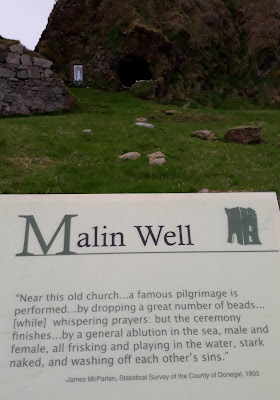
Read above how cermony finishes. I had to do this part on my own! 
At the coast at Malin Well there are huge rock formations in this secluded top corner of Inishowen. You can easily see why the recent Star Wars film was shot in this area. (Star Wars addicts will enjoy the fact that today is actually May the fourth!!)


View from Ruins of Church at Malin Well
It’s so peaceful here on my own and I pause for a while at the Grotto and Church ruins and at the ‘Wee House of Malin’ where a hermit once lived in a cave. I wonder what possesses someone to go off on their own like that!    

I follow the coast with Malin Head clearly visible now and carry on along a lovely grassy stretch (perfect for running on) for a good half mile. At the end of the grassy section I take a rough trail inland that takes me back up onto the country road (the ‘Inishowen 100’). 

Just a few miles to Malin Head
I come to a T junction after a while and take a right towards Malin Head. When I reach Malin Head itself there’s a bit of a hill to run up. I can see a group of tourists at the top watching me suffer but when I reach the top they cheer me on! They are driving the Wild Atlantic Way with Joan Crawford from Failte Ireland.

Joan Crawford (Failte Ireland -Wild Atlantic Way) 
So I’m now at the top of Ireland – the most northerly point! It’s called Banba’s Crown, after Banba who was one of the mythical queens of Ireland. I walk down to the edge of the cliff at Malin Head and see huge letters spelling out the word EIRE formed from placing stones together. I notice as I got close that the stones are all cemented together. They’ve been here since World War 2 and it was to signify to passing planes that Ireland was a neutral country during the war.
 
EIRE 'sign' at top of Malin Head to signify WW2 Neutrality
At Main Head I even get to enjoy some water and coffee. When I ask directions from the man at the coffee stand, it tells me I have lots of hills to climb but he says in all seriousness ‘at least you can free-wheel down the other side’. I look at him and say ‘you know I’m just running, not cycling’. ‘Oh’ he says, I thought you were cycling!.
 

I leave Malin Head and continue around the top corner of Ireland and so I’m now heading south! On this west side of Inishowen it’s much easier to get to the shore and at White Strand Bay I make my way down to the beach and run along this sometimes rocky beach for a few miles. My way becomes impaired as I’m running alongside a wide stream. Eventually I come to a wee bridge and I’m happy to join up with the ‘Inishowen 100’ country road again.
La Rochelle visitors meet strange man! 

I stop to talk to a few French tourists from La Rochelle and continue on this quiet but hilly section. It’s brightening up now and soon I reach a beautiful viewing point overlooking the spectacular Five Fingers beach. I follow the road downhill, take a right turn at a crossroads and right again at the church and reach the amazing Five Fingers (Lagg) strand. This beach was voted in the top 25 beaches in Ireland and best for ‘Solitude’ which was very apt as I was the only person on the beach.

Five Fingers (Lagg) Strand from the top

 I was privileged to have the place to myself and it was perfect for running on too. Of course as the Greeks say ‘Sand is for the feet of the Runner'!


Five Fingers - I have it all to myself


Five Fingers Sand Dunes (some of the highest in Europe!)

I continue along the beach and come back onto the main road again and soon come to Malin town where I stop for a drink of water and follow the Carndonagh road. Then after about 3k I take a right turn (signposted to ‘Driving Test Centre’ and so avoiding Carndonagh).  


The Carndonagh by-pass
I come back on the main road, take a right towards Ballyliffin and after about 5k I take a right again into Doagh Island (or Isle of Doagh).


Famine Village on Doagh Island


See blue sign about Ballyliffin Coastal Run - it goes around Doagh Island 


In memory of Brendan Doherty
The isle of Doagh was once an island but, over time, the channel silted up and it became joined to the mainland. This detour of mine of about 12k to circle the island was well worth it. Doagh (pronounced ‘Doe’) had plenty to keep me entertained with spectacular scenery, standing stones, signs and stories explaining the original of various houses/townlands and a Famine village of thatched cottages. Even when I eventually circle the whole ‘island’ I have the beautiful Pollan Strand to run on with the sea on my right and the wide beach (lucky for me the tide is out!) and Golf Links on my left! The Irish Open Golf Championship is taking place here in Doagh/Ballyliffin this summer. It’s the perfect location and the perfect place to finish my longest coastal run so far!   
Sign at Famine Village on Doagh, just outside Ballyliffin.


Stage 18: Ballyliffin to Buncrana
Saturday 5th May 2018 (37k or 23miles)
 
I leave the friendly Lynch’s at Ceecliff Guesthouse in Culdaff after a nice breakfast (poached eggs and smoked salmon) and drive to Ballyliffin. It’s slightly cool but I quickly warm up as I head off and very shortly (after about 3k) I arrive in the village of Clonmany.

Clonmany
This village has been unlucky with freak weather in the past. In 1840, the village experienced an earthquake. The Belfast Newsletter reported that "some people were thrown from their chairs, and greatly alarmed." Then as recent as August 2017, the village was severely affected by flooding. Some residents were cut off due to rising river levels and had to be rescued from their homes.


I saw these abandoned shoes at Tullagh Point (previous Coastal Runner calling it a day?)
 
I head for the coast again as far as Tullagh Point and continue through the townland of Dunaff and I take a right at the Post Office. This brings me on to a perfect coastal country road which eventually turns into a nice downhill rough track that takes me all the way to Lenan Pier. Fanad Head is clearly visible on the other side of Lough Swilly.

At Lenan Bay I’m tempted to follow a rough coastal road and track over the Urris Hills. However, looking at the Ordnance Survey Map, the track seems to disappear half way over the mountain. This coastal route would definitely be a much shorter way to reach Crummiest Bay and Dunree Head. After my exploits of struggling through Inishowen Head in April, I’m reluctant to cross over rough terrain, although this coastal route looked very achievable on a day like today.
 
 
The other reason I don’t take this rough coastal way today is because I’m hoping to meet up with Helen and Neill. Helen (fellow coastal runner as far as Derry/Donegal border) and Neill are cycling today around the Inishowen peninsula. I know they’re going to have to come over the Gap of Mamore and I’m really looking forward to meeting them. In fact that idea of meeting them is giving me great motivation to keep going. I leave Lehan Bay and head inland to get to the foot of Mamore Gap. It’s a long steep climb up to the top. For cyclists it’s the steepest climb in Ireland. The maximum gradient is 22% and even the average is 12.4%.  I decide to walk!  


View from Mamore Gap


Amazing views all the way up here and at the top of Mamore Gap there’s a small grotto and well called Saint Colmcill’s Well (or Saint Egney’s Well.) There have been pilgrimages to this well as far back as the 6th  Century.


So glad to see this man at the top of Mamore Gap


I wish I could lift my legs! 


I descend from Mamore Gap. I’m still looking out for Helen and Neill (cycling Inishowen ‘100’) but I know I can’t miss them as they have to come over the ‘Gap’ too. I try to run down the steep hill but even that’s painful and I have to walk again. I get to the bottom of the hill at the road junction and sit on the bridge (over the river Owenerk) and wait. Suddenly in the distance I can hear Helen shouting ‘Gerry, Gerry’ and I spot two cyclists coming up the road from the coast. 


Neill and Helen at foot of Mamore Gap


Sunny Donegal at Mamore


It’s really made my day to meet them and the three of us stop for a while by the bridge in the sunshine. 
Helen and Neill tackle Mamore Gap


Sad to say goodbye to Helen & Neill


After Helen and Neill left I really struggled to run. I told my legs so many times to lift and move but they refused to obey me!

Still the road down towards the coast at Dunree Head was amazing with magnificent views over the sea and across to Portsalon, with Ballymastocker Strand stretching out and smiling in the sunshine!


At this stage I'm struggling to keep up with these two!
 
Back on the Wild Atlantic Way again
 
I probably ended up walking almost all of the last 10k to Buncrana. Nevertheless, I’ve been so lucky with the weather yesterday and today and to finish I have a nice path along the beach and shore in Buncrana. 
 
So glad to see this sign!


Buncrana: Means bottom of river Crana 


I’ve now conquered the whole coast of Inishowen without even getting wet! From Derry City all the way around the Inishowen Peninsula, it’s taken me 170k (106 miles) to reach Buncrana... Now for the rest of Donegal!     


Total distance to date: 786k or 491miles  

Next Stages: Sat 9 June: Buncrana to Letterkenny and Saturday 30 June: Letterkenny to Portsalon