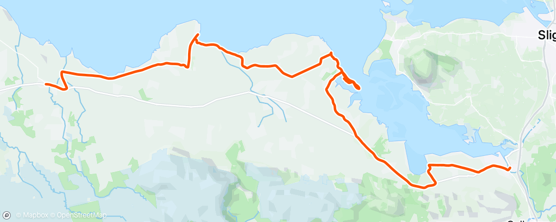
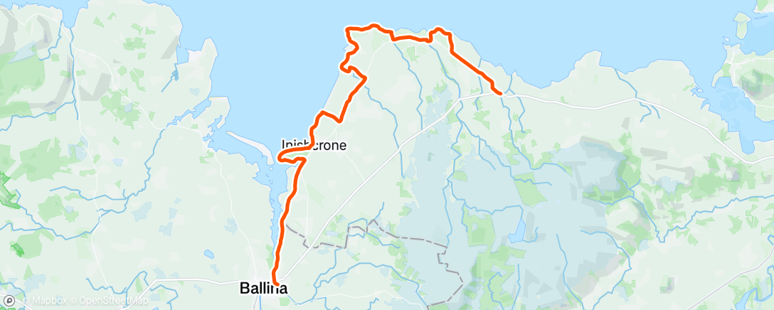
STAGES 45&46 Ballysadare to Ballina
Stage 45
Co. Sligo: Ballysadare to Dromore West
Saturday 14 March 2020
40.3 km or 25 miles

‘She bid me take love easy, as the leaves grow on the tree;
But I, being young and foolish, with her would not agree’. (Salley Gardens by WB Yeats)
I’m travelling on my own this weekend as we were worried about taking Brian away, especially in these worrying times of the Coronavirus. I drove down on the Friday evening, staying two nights in the lovely ‘Twin Trees’ hotel in Ballina. There is an eerie atmosphere in the hotel and I even spotted one guest wearing a face mask.
I started today's run in Ballysadare (town of the waterfall of the oak) where the song ‘Salley Gardens’ originated. You could say WB Yeats co-wrote it. He said it was an ‘attempt to reconstruct a song that he heard an old peasant lady singing in Ballisodare’. I was lucky too that I was able to depend on public transport this weekend as I was travelling between Connacht’s second largest town (Sligo) and the fourth largest (Ballina).
Ballysadare was originally a major gathering place for all surrounding districts and Saint Columba visited here in 575 AD 'where all the prelates of the neighbouring regions, and vast numbers of holy men and women had come to meet him’. ’Also, another famous saint, Féichín was born in the townland of Billa in the parish of Ballysadare.
Leaving Ballysadare I ran along the main
Ballina road for about 2km until I came to the sign for Streamstown (at the church and crossroads) and took a right turn.
 |
| Coming back up from Streamstown with Ox Mountains ahead |
This was a quiet country road with
Ben Bulben still visible in the distance and as the boreen looped around again, the
Ox mountains (or Slieve Gamph) came into view. I came back onto the
main road again and soon arrived in the village of Beltra (Strand at the Mouth). Strangely too, for some reason, there’s a crater on Mars called Beltra!
 |
| View from Streamstown |
In Irish mythology, the Firbolg King met his death here
after the first Battle of Moytura.
About 1km after Beltra, I took another right,
signposted ‘Coast Road’. I followed this road for about 2km until I came to a
crossroads and then I took a right towards Portavaud down to the shore at
‘Gallyhouse Strand’. Here I spotted a man on crutches coming out of the water with
seaweed over his legs. I got talking to him (Rodney) and he explained that he
had a biking accident and heard that seaweed was a good remedy. I had read too
this area was famous for harvesting seaweed.
 |
| Rodney having a seaweed bath! |
 |
| Rodney and Dell Boy (me!) |
The weather now turned wet and
miserable as I circled Portavaud Point at the end of the peninsula. Lots of
sheep in this area and all protecting their young (just born) lambs.
 |
| Sheep protecting new born lamb |
I turned
back from the Point and carried on running along the shore. However, there were
only rocks on the coast now (it was high tide which didn’t help!) so I had to run inland, through a few muddy fields and getting caught in thorny bushes. I was able
to get down on the shore again and eventually I spotted a house which led me
onto a country road (Derk Road). It was still raining as I made my way up to a
T junction where I took a right turn. I continued running on this road for
about 2km until I saw the sign for Dunmoran Strand.
 |
| Dromoran Beach |
When I arrived on this
beautiful beach I was soaked to the skin and I hesitated as I wasn’t sure
if I could continue along the shore all the way to Aughris. I debated with
myself whether I’d be better following a country road instead. In the end I
decided to risk it on the beach and it paid off. (I was probably lucky that the
tide was half-way out).
 |
| Crossing bridge between Dromoran and Aughris |
It was a sometimes a rocky shore but soon I got through
it and I was well rewarded as there was a pub (the Beach Bar) at the end. I decided to call into the pub and had a nice pot of tea while
my clothes dried by the fire! (I was surprised there were so many people in the
pub with all the warnings about the Coronavirus!)
 |
| The Beach Bar at Aughris |
Anyway, I got talking to a
couple of guys in the ‘Beach Bar’ asking them for directions to Easkey and
Dromore West. They assured me I’d reach my destination in ‘no time at all’. I’m
always amazed in these situations how non-runners in a pub can over-estimate
how fast you can run!
 |
| Aughris Pier |
After leaving the ‘Beach Bar’, the rain came down again. I
soldiered on, following the coast road towards Easkey. I knew the Ballina-Sligo
bus only ran every two hours so I was trying to make sure I would get the 2.30
bus from Easkey (or 2.45 from Dromore West). As I got closer to Dromore West I
realised I wouldn’t make it on time to Easkey so I left the coast road (just
before the big hill) and arrived soaked to the skin in the village
of Dromore West.
 |
| The sign for Easkey! |
At the bus stop in Dromore West I called into a café and ordered
a coffee. I had barely got my drink when the bus arrived to take me back to
Ballysadare. Luckily, I had spare clothes in my car. It was probably my wettest
coastal run since crossing the Foyle Bridge in Derry at the end of Stage 15 back
in March 2018.
Stage 46
Dromore West, Co. Sligo to Ballina, Co. Mayo
Sunday 15 March 2020
48.4 km or 30 miles

Thankfully it was a much nicer day today. I decided it would be more
practical to do this run clockwise (or with the sea on my left-hand side) and then
get the bus back to Ballina from Dromore West. I am depending on public transport this weekend so I had to make this practical decision. Before I left Ballina, I got
talking to Rachel (Manager of Twin Trees Hotel) where I stayed and she kindly
donated 50 Euro to Clifton School. Thank you, Rachel! I really appreciated that, as the following day all hotels in the country were closed due to the coronavirus and Rachel (and her business) probably needed the money more than Clifton School.
 |
| With Rachel, Manager of Twin Trees Hotel |
Leaving Ballina, I followed the river Moy all the way towards
the sea. Years ago, I remembered going to a pub along by the river to hear Jazz
music on a Sunday morning, but it was very quiet here today.
 |
| Leaving Ballina with river Moy on my left |
 |
| Half way between Ballina and Inishcrone |
When I reached Inishcrone, I took a left turn across a field (at the ‘Pig’ statute and the ‘Diamond Coast Hotel’), ran along a stream and circled the whole Golf Course.
 |
| The Pig at Inishcrone that was 'possessed by an evil spirit and ate everyone it encountered'! |
Eventually I got down onto the
beach from the golf course and ran along this strand for miles, with Bartragh Island now so close on
my left.
 |
| American couple walking on Inishcrone beach |
 |
| Keeping our distance - only selfies today! |
It turned out to be a beautiful day and even at high tide, Inishcrone
was such a lovely beach to run on. I passed the seaweed baths and then along a road and trail
after that ….but then the road abruptly ended at the coast! I decided to rough
it along here, crossing through fields and climbing under (and over) electric
fences! I did eventually find a country road that brought me back onto the R297
road.
 |
| A famous writer in 1670 who died from wounds he received in protecting a woman from insults! |
I kept running on the main road and after about 3km, and just after
the sign for Leaffoney School, I took a left turn at the L6409 at the Cabragh
river. I followed this road down towards the coast, taking a left turn towards
Pullaheeney Harbour just before the Harbour Bar.
When I reached Pullaheeney
Pier I expected the road to continue along the coast (as it did on the Ordnance
map!) but there didn’t seem to be any road north of the pier. I got talking to
a young couple in their car and they also wondered where the road had gone! It
turned out that some sand and rocks from the sea had covered the road over the
years.
 |
| The road taken by the sea! |
 |
| But still marked clearly on map! |
I carried on running over the rocks and after about 1km, I found the road again. When it eventually turned inland, I came to a junction with two
left turns. I took the second left not really sure where it would lead to, but
I knew it was down towards the coast. When
I got to the shore there was no coastal path but I decided to rough it along
the coast. There was a lower cliff shelf that I was able to run on and I
carried on along here, reaching the headland at Lenadoon Point.
 |
| Running on cliff shelf at Lenadoon Point |
 |
| Wild Atlantic at Lenadoon Point |
With all talk about the Coronavirus, the term
‘self-isolation’ is being used a lot now. No danger of me catching any virus as I was completely on my own along this
part of the Atlantic coast. I think it was at a place called Brownstown, where the Finned River flows into
the sea, that I eventually left the coast. It was about 2.30 at this stage and the
sign said Easkey was 3km.
 |
| Welcome To Easkey (which means Fish in English) |
 |
| Quiet men in Easkey |
I was so glad to arrive here as I hadn’t eaten or drank anything since 9.00 this morning. I stopped briefly in Easkey (refuelling!) but I was conscious that I needed to be in Dromore West to make the 3.50 bus back to Ballina. Just after passing Easkey I took a left turn signposted to Easkey Beach and followed the coast road for a while and then came back onto the R297 again.
 |
| Almost there but I took the coast road which made it 9km! |
I just made it to Dromore West on time and was one of only two passengers on
the bus to Ballina. So now I’ve reached Co. Mayo. With talk of lockdowns on the news it’s hard to know when exactly my
next coastal run will take place, but the adventure will definitely continue!


No comments:
Post a Comment