Wednesday, 27 December 2017

‘Winter Miles makes Summer Smiles’  Denis Scott (NDAC)


Stage Eleven: Drains Bay, Larne to Cushendall (41k or 25.5miles)

<Author: Gerry O'Boyle>


Saturday 16 December 2017


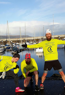
With only nine days to Christmas Day, today’s run had a kind of festive feeling about it. The beautiful green glens of Antrim were still covered in snow to add to the occasion. And to complete the whole picture, Helen was wearing her Christmas hat with ringing bells!


We have to thank Laura McAllister (Helen’s friend) for meeting us in Cushendall and driving us back to our start at Drains Bay (just north of Larne) – that saved us having to take two cars today!

We were delighted too that Laura’s husband, Phelim ran with us for most of way today. Phelim, Laura and wee Jude live in the beautiful village of Glenarm and Phelim took time off from plucking turkeys to join us on the Antrim coast. However with both Phelim and Sean supporting similar beards, shorts and shirts it was confusing at times today! 
Phelim & Sean


Sean came straight from the night-shift for today’s run. He also had a wee 100 mile run last week through the Wicklow Mountains so maybe he’ll go easy on us today. Meanwhile Debbie from PhysioWorks is keeping my body in order and has given me special exercises which involve moving my pelvis without moving any other part of my body - easy enough to do (if you happen to be a Hawaiian dancer!)    


It was 9.00am (just after sunrise) when we got to Drains Bay (just north of Larne) and in our wisdom we decided to tackle the Larne parkrun that takes place in Drains Bay. We got a great welcome from the organisers of the Larne parkrun and we even got the benefit of a local photographer (Bill Guiller) who also caught up with us later at Glenarm and took more pictures there. Thank you Bill!


After completing the parkrun we eventually leave Drains Bay at 10.30am. Such a beautiful part of the world today in Co. Antrim and we had the perfect weather with blue skies and lovely sunshine as we reached the village of Glenarm. Glenarm is the first of the nine glens of Antrim and claims to be the oldest town in Ulster having been granted a charter in the 12th century. 


We hugged the coast the whole day, passing through such lovely villages and amazing views across to Scotland, with the Mull of Kintyre now only about 20 miles away. Also the tall island of Ailsa Craig could be clearly seen in the distance jutting up from the Irish Sea. (apparently the Ailsa Craig Island/Rock is still for sale and reduced now to £1.5m, down from original £2.5m – a bargain I’d say!)


We leave Glenarm and the sun is still shining as we arrive in Carnlough which is probably our half way point today. A beautiful rainbow appears over the hills which really should have warned us that rain was ahead! Sean stops to take pictures of the rainbow but Helen, Phelim and I carry on towards Waterfoot along the winding Antrim Coastal Road.   


Antrim Coast Road

The 40k coast road (Larne to Cushendall) that we’re running along today was built by William Bald between 1832 and 1842.  Bald also had the unique idea to blast the cliff face which then fell down onto the foreshore to form the base for the new road. Up to that point there were no proper roads in this area and the 12-15 miles of sea to Scotland was a much easier trading route.


Phelim has to leave us (more turkeys to pluck!) and so Helen and I carry on to Waterfoot with Sean (still trying to stay awake) a few hundred metres behind. Gradually the sun disappears, replaced by the rain and wind and the temperature drops. It’s a real struggle now to keep going in such miserable conditions.


My body and especially my feet are suffering (and blistering!). I was listening to Radio Ulster last month about a traveller/explorer from Castlerock called Leon McCarron. He was describing how he was walking through Jordan after a long day’s trekking when a local man, invited him into his home and together with his son, proceeded to wash Leon’s feet. If only we could be so lucky on the Antrim coast!     


Helen and I eventually reach the outskirts of Waterfoot and very slowly make our way (walking/running) to the centre of the village. We stop at a shop for drinks and the girl there tells us (the greatest news!)  ‘it’s only one more mile to Cushendall’.  We wait outside the shop for Sean and when he arrives we continue together for the final stretch. It might be one of the shortest days in the year but it seemed a long long time since I parked my car in Cushendall this morning. And so Christmas is almost here ...and our adventure continues again in 2018.     


Total distance to date:  449k or 280.5miles      


Next stages: Sat 20 Jan (Cushendall to Ballycastle) and Sat 10 Feb. (Ballycastle to Portrush).


If you’d like to Donate to Clifton Special School, please see below.


Thursday, 16 November 2017


‘If you can take it, you can make it’ Louie Zamperini
Stage Ten: Islandmagee to Carnfunnock, Larne (43k or 27miles)


<Author: Gerry O'Boyle>


Saturday 11 November 2017


Dawn is just breaking as we arrive in Islandmagee to start stage 10 of our coastal adventure. Since our last run last month we’ve had Hurricane Ophelia and Storm Brian but today the weather wasn’t too bad at all – a little cool but we quickly warm up after a mile or two.


Islandmagee-the Beanies
In early medieval times Islandmagee was known as Semne and we met a lady who told us that the native Islandmagee people are known as ‘beanies’. This comes from the fact that years ago, beans were grown here to supply nitrogen to the soil.

It’s just the three regular runners today (Helen, Sean and me) and it’s the first coastal run on our own since April (Kilkeel to Dundrum).

We leave Earls Cafe at exactly 8.00am and continue north along Mulloughboy Road, taking a left turn after about 500 metres into Portmuck road. After another 500 metres we take a right leading us down to the lovely Browns Bay beach. We continue along the shore passing by Larne Golf course on our right and then taking a left into Ballylumford road. We’re now running along the west side of the Peninsula and shortly we pass the site of N.Ireland’s main power station at Ballylumford.

Ballylumford (lapsed) ferry:


Ballylumford power station with Carnfunock visible
across the headland (our first uphill of the day)

I had read somewhere that there was a ferry crossing between Ballylumford and Larne. I rang the ferry company and they informed me that due to insufficient demand the ferry stopped running 18 months ago. So instead of a nice short ferry trip across to Larne we faced a much longer round trip!

About a mile further south we pass the ‘Druids Altar’ Dolmen. This monument dates to 2500BC and some archaeologists even date it as a Neolithic Tomb dating back as far as 4000 BC. 


Oddly a house has been built immediately behind the Dolmen
Ballylumford Dolmen


As we continue running we realise that Islandmagee is quite hilly and in fact hills dominate our whole story today! It might be a coastal run but this morning we seemed to be climbing all the time. It’s brightening up now though and we have lovely views across to the hills on the mainland, which we will tackle later!

Witchcraft Trial

In Terry Eakin’s blog, he refers to a Witchcraft Trial in 1710 where eight women in Islandmagee were convicted of witchcraft and sentenced to a year’s imprisonment. As recently as 2015 a memorial was proposed by the author Martina Devlin. However the memorial was objected to by TUV councillor Jack McKee who believed the plaque could become a "shrine to paganism" and furthermore Jack stated that he wasn't convinced that the women weren't guilty!

A beautiful road for a run! Sean couldn't
hold himself back - Run Forest Run!

 We continue along Ballylumford road which joins up with Millbay Road on the west side of Islandmagee, keeping the sea (as always!) on our right hand side. We come back onto the Low road and eventually we come to a wee roundabout, take a right turn and sadly leave Islandmagee. 

Crossing the bridge to leave Islandmagee

I should mention that Helen was worried that today’s stage would be too short, so to appease her, I planned a slight diversion inland to add a few more miles to our journey! We cross the bridge (leaving Islandmagee peninsula) and decide at this stage not to take the main/busy road into Larne. Instead we cross the road and head up to the village of Ballycarry. It’s a tough (and long!) climb up to Ballycarry but the views from the top are worth it as we look back across to Islandmagee and Scotland in the distance. We take a right turn at the top of the hill into Hillhead Road.      

View from the village of Ballycarry

Ballycarry

Ballycarry, previously called Broadisland, boasts the oldest Presbyterian congregation in Ireland - founded in 1613. It’s also the home of James Orr (known as the Bard of Ballycarry) who wrote ‘the Irishman’ which contains the famous lines

 The savage loves his native shore,
Though rude the soil and chill the air;


We continue along the quiet country roads through Hillhead Road which joins up with Ballypollard Road and after a couple of miles we take a left turn into Craiganee Road, then a right turn into Newlands and eventually we come to the beautiful village of Glenoe. We face another tough climb (more hills!) up to Glenoe Waterfall.


Helen's face says it all!
Glenoe Waterfall - worth the 19% gradient climb!


I don’t think Helen is really that impressed with my ‘inland diversion’ and admittedly the terrain here is not as flat as the coastal route! However Sean is not complaining and is now in complete ultra-marathon mode as he sprints up the steep hill in Glenoe. We’re now four miles inland so maybe it is time to head back to the coast again.


Refreshment stop at A.McDowell Stores
Alas the poppies purchased during our run
had mostly fallen off but we made a
stop in Glynn during the 11th hour.

At its Remembrance Day today we pause to pay our respects at the War Memorial at the village of Glynn. We’re now only two miles from the town of Larne.


Friends’ Goodwill

Exactly 300 years ago in 1717 a small ship called ‘Friends Goodwill’ made her way out of Larne Harbour as one of the first emigrant boats to cross the Atlantic. The vessel encountered a storm, food ran low and it was reported that the crew caught sharks and dolphins for food and collected rain water on the deck. The historical account of the voyage tells us that things were so bad that lots were drawn as to who would be eaten first when the worst extremity came. Thankfully in September 1717 (four months after leaving Larne) the City Commissioners in Boston were apparently informed that ‘Forty nine miserable persons arrived from ye North of Ireland on a single vessel’

Meanwhile back in 2017, three ‘miserable persons from ye North of Ireland’ arrive at last in the town of Larne, also tired and hungry!


From the other side: Looking across to
Ballylumford where we started the day

Sean has a ‘romantic connection’ with Larne and so is able to guide us through the town and eventually down to the coast at the majestic Chaine Round Tower (built in 1888 as a memorial to James Chaine, an MP who developed Larne as a sea port). As it happens, Larne Athletic Club are just finishing their Club Handicap Race today beside the tower. We stop to chat with some local runners outside the Leisure Centre and they offer us tea, coffee and biscuits which are just what we needed before we complete the last three miles to Drains Bay. 


Larne Leisure Centre
Gerry, Sean and Helen at Chaine Tower
Thank you for the warming tea Larne AC
It’s a lovely run in along the Antrim Coast, passing under the famous Black Cave Tunnel and finally arriving in Carnfunnock Park at 1.00pm. And it’s great that Maureen and wee Brian are there to meet us as we complete today’s coastal run .......and so our adventure continues!  
Black Cave Tunnel
Final approach to Drains Bay
Brian met us for chips at Carnfunnock!


Total distance to date: 408k or 255miles      


Next leg: Saturday 16 December (Carnfunnock to Cushendun)

If you’d like to Donate to Clifton Special School, please see below.

Wednesday, 11 October 2017


Keep your eyes on the stars, and your feet on the ground. T Roosevelt


Stage Nine: Belfast to Islandmagee:


Claire & Gerry: 40k or 25miles

Helen & Sean: (via Waterworks parkrun) 48k or 30miles   


<Author Gerry O’Boyle>

Saturday 7 October 2017  

We started our run today in the city of Belfast which really borders two counties, Co. Down on the east of the river and Co. Antrim on the west side. We’ve already completed all 200 miles of the Co.Down coast (from February to September) and this morning we crossed the Lagan to complete the rest of N.Ireland.

Helen, Sean and I were delighted to be joined in Belfast by Claire Garrad (Claire’s fourth run with us). So, the four of us start together at 8.45am at the new Titanic building. It’s quite busy in the Titanic Quarter even at this time of the morning and really great to see this whole area being revitalised. The weather is dull but at least it’s not raining as we set off on today’s adventure.
Gerry, Sean, Helen and Claire in front of SS Nomadic
 

Once we cross the river, we take a right turn, passing the ‘Big Fish’ or ‘Salmon of Knowledge’, remembering the story of how Fionn McCumhaill got his wisdom. We’re heading north now and we go under the M3 Motorway and come to Donegal Quay.
Sean gains some knowledge

Sailortown

We pass through the old docks area of Belfast, known locally as Sailor Town. A local guy, Anthony Tonor wrote a great song in 2010 about this neighbourhood (called it Sailortown of course!) and started singing it in the nearby Rotterdam Bar.
 
‘The walls in the city have a lot to say, about the UVF and the IRA but these walls say nothing about who I am, when I’m singing in the garden at the Rotterdam, doing Brown Eyed Girl and Whiskey In The Jar.’

At this stage Helen and Sean head across to north Belfast to the Waterworks parkrun and Claire and I continue through Sailortown. Before our team separates, Helen reminds us to take a picture of Sinclair Seaman’s Presbyterian Church, a church built as a haven for sea merchants.

Built in 1856 -Sinclair Seaman Church is a
historical maritime building of worship
 

Art on the wall of Creed Café - Sailortown
I’m struggling with a pelvis/hip injury today and I’m quite pleased not to be joining Helen and Sean on their ‘detour’ through north Belfast and the parkrun. In any case, it’s great that Claire has joined us today and she’s such great company for me. We all agree to meet up later in Carrickfergus. 

Claire and I continue along Corporation street, which leads onto Garmoyle St, Whitla St and Duncrue Street. At a wee roundabout we take a left and then a right into Duncrue Road. After a while we cross-over Dargan Road and at last we join the Cycle/Walk path with the M2/M5 Motorway close by on our left. This is actually part of the route of the Belfast Marathon. We pass Hazelbank Park and even when we get to Gideons Green, we still have a promenade and wide footpath to run on. The sky is very grey now and we struggle through the showers without getting too wet. We pass Jordonstown, Greenisland and eventually we arrive in Carrickfergus. Claire measures it as 11 miles so far and we can relax now knowing we still have to wait for Helen and Sean to arrive.

Looking back toward Belfast docks from the M2 towpath


Helen and Sean had to cross the motorway
before running alongside it
Cavehill (Napoleon's nose) and Belfast Castle
view from the M2 towpath


Carrickfergus

Sean of Orange...
For a period in the 17th century Carrick was actually larger and more prominent than Belfast and back then Belfast Lough was known as Carrickfergus Bay. It was even here that William of Orange arrived in 1690 on his way to the Battle of the Boyne where he, of course defeated his father-in-law King James. Claire and I stop to talk to a couple and admire the beautiful medieval Carrickfergus Castle still very well preserved today.

Claire and I had arranged to meet Helen and Sean in Creeds Cafe in Carrick and we just manage to get into the cafe before the heavy rain. We get nice seats on high stools by the window, drinking our tea and coffee. Eventually we spot the two lime green shirts (and Helen’s new pink shoes!) in the distance. In Creeds Cafe we also get talking to two runners and we tell them our story.

We leave Carrick and we’re still able to run by the shore on a wide footpath. About a mile after leaving Carrick we take a right turn at Magills Avenue and arrive at what once was a separate village (and strangely named!) Boneybefore. Apparently in 1760 French soldiers were told that this village was ‘a bonny wee place just before Carrick’. This was where US President Andrew Jackson’s parents lived.
Claire and Gerry at Carrick Harbour
Claire and the stone snail(?)
at Jordanstown


Carrick Castle
 

President Jackson

Andrew Jackson served as the seventh US president from 1829 to 1837 and was involved in what is believed to be the first attempt to kill a sitting President when someone aimed a pistol at Jackson, which misfired. Luckily for the president the brave Davy Crockett happened to be there and restrained and disarmed the culprit.

We continue here close to railway line (and away from the main road); and then along by ‘Old Turn’ road which leads to Loughview Drive which turns into a rough (and flooded) path. We arrive back out on the main Whitehead road at the village of Eden. Nobody said this adventure was going to lead us to Paradise but today we did reach a place called ‘Garden of Eden’. We couldn’t resist a good photo opportunity here and Helen even popped into a local shop to buy some apples.
Gerry, or Adam as we called him ;)
Apples in the Garden of Eden!
It’s a busy road as we leave Eden but at least we have a footpath (sometimes very narrow!) all the way to Whitehead. After about four or five miles, when the road runs closer to the sea, we stop to admire the view. Sean points out various landmarks across the bay. We can clearly see our home town, Bangor and even Scrabo Hill, Newtownards on the other side of the Lough.
Bla hole, Whitehead
Bla hole looking towards Belfast port
As we come into Whitehead we take a right turn into Prince of Wales Avenue and arrive down at the railway station. Whitehead is the town with no streets apparently - it has no streets with the suffix ‘street’ in its name - so no High Street or Main Street. We stick to the coast, passing by lovely buildings in contrasting colours and follow the Blackhead Path to the Lighthouse. It’s a tough climb up to the Lighthouse (lots of steps!) but well worth it for the magnificence views across the Lough and over to Scotland. Better still, the weather is improving now, the sun is even threatening to shine and the blackberries are still available for us hungry runners!

Whitehead train station
Whitehead train station bridge


running towards Blackhead Lighthouse, Whitehead

Sean, Claire and Gerry at Blackhead Lighthouse


The ice cream that the thought of
sped up the previous 2 miles!
We leave the Lighthouse and run downhill along a narrow (almost traffic free) road called McCraes Brae. We soon join up with the ‘main’ Ballystrudder road and take a right, heading north into the heart of Islandmagee. Somehow the conversation turns to ice-cream and Claire and Helen have heard rumours that at ‘The Rinkha’ in Islandmagee they do the best ice-cream in N.Ireland. Yes we’re now on the Peninsula of Islandmagee and after about half a mile we take a right into Middle Road and spot ‘The Rinkha’ in the distance and of course we stop for ice-cream which definitely lives up to its reputation! We cross the road here in Ballystrudder and call to the Gobbins Visitor Centre (the actual Gobbins cliff path is closed already for the winter). We continue on and, just after we pass Ballystrudder we take a right turn into Gobbins road. 


Halloween at the Rinkha!


The Gobbins

The Gobbins is a cliff-path on the east side of Islandmagee. It runs across bridges, past caves and through a tunnel. The Gobbins was created for the Belfast Railway Company and first opened to the public in 1902. Advertisements of the time declared ‘the new cliff path with its ravines, bore caves, natural aquariums ... has no parallel in Europe as a marine cliff walk' ...but the railway company got into financial difficulties and the path was closed in the run up to World War II. However, from 2011-2015, Larne Borough Council led a project to reopen The Gobbins. A series of new bridges and galleries were constructed and installed during 2014-15.


Our view of the Gobbins

Claire, Sean and Helen enjoying the sunny
views over the Gobbins and Copeland Islands


Image of the Gobbins - not taken by us, we didn't get that close!


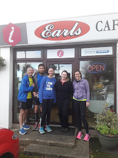
It’s a long hill and tough climb up the Gobbins Road (and my legs are letting me down again!). However the sun has come out now, the sky and sea are blue and when we reach the top, there are lovely views of the Gobbins cliff path just below us. After about another 3 miles along Gobbins Road we eventually come to a T junction. We take a right turn into Middle Road and finally reach our destination at Earls Cafe, Mulloughboy. The proprietor at Earls is Shalana, who has a friendly welcome for us and we are glad to tuck into some nice homemade food. (Shalana also makes a donation to Clifton School). We tell her we’ll back in 5 weeks time for the start of Stage 10 of our coastal run.
Gerry, Sean, Claire and Helen with Shalana
after a good feed in Earls Cafe


Total distance to date: 365k or 228miles      

Next leg: Saturday 11 November (Mullaghboy, Islandmagee to Carnfunnock, Larne)

If you’d like to Donate to Clifton Special School, please see below.